What is it?
The federal government has a vested interest in protecting taxpayer investments by ensuring the projects it funds are more resilient to current and future flood risks. Originally established in 2015 through Executive Order 13690, the Federal Flood Risk Management Standard (FFRMS) was intended to encourage federal agencies to consider and manage current and future flood risks in order to build a more resilient nation. The standard was revoked by the next administration, but then reinstated in 2021 through Executive Order 14030, Climate-Related Financial Risk. The final rule and policy became effective on September 9, 2024.
- The FFRMS recognizes numerous factors, such as climate change and other future land use changes, may increase the likelihood of future floods exceeding the currently mapped base flood elevation.
- The FFRMS gives federal agencies some flexibility in meeting new requirements. For example, each agency can choose from three different approaches for establishing the flood elevation (“how high”) and corresponding flood hazard area (“how wide”) used for project siting, design, and construction (see the graphic below).
- The three approaches are:
-
Climate-informed Science Approach (CISA) - for use only in areas where CISA data is currently available and actionable to define the FFRMS floodplain using the Federal Flood Standard Support Tool. CISA data are only available for eastern coastal areas and not currently available for the Pacific Northwest.
-
Freeboard Value Approach (FVA) - +2' for non-critical actions, +3' for critical actions (these terms are defined in the next paragraph)
-
500-year Floodplain/0.2-Percent Annual Chance Flood Approach - the area subject to flooding by the 0.2% -annual-chance flood, or the 500-year floodplain.
- This ensures federally funded projects are more resilient to current and future flood risks while protecting taxpayer investments.
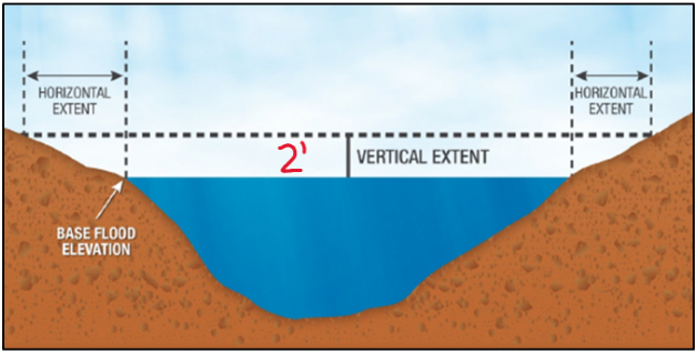 The FFRMS floodplain is based on future flood risk and expands the 100-year floodplain both vertically (based on projections of increased flood height) and horizontally, by including the horizontal area impacted by a vertical increase in flood waters. The Freeboard Value Approach (FVA), shown above, requires 2' freeboard for non-critical actions or facilities.
Currently, the Freeboard Value Approach (FVA) and the 500-year Floodplain/0.2 Percent Annual Chance Approach are acceptable for use in Washington State, depending on data availability. Under the FVA, non-critical actions or development are required to build the lowest floor 2 feet above the BFE. Critical actions or facilities, as defined in § 55.2(b)(3)(i), are those activities for which even a slight chance of flooding would be too great, because such flooding might result in loss of life, injury to persons, or damage to property. Critical actions are required to build the lowest floor 3 feet above BFE. Critical actions include police stations, fire stations, roads providing sole egress from flood-prone areas, hospitals, and nursing homes, but not independent living for the elderly.
If your community has elevation data available for the 500-year (0.2% annual chance) floodplain, the community must evaluate whether the 500-year Floodplain Approach or FVA provides the most protection for the project scenario (critical vs. non-critical action/facility). If 500-year floodplain elevation is not available, the decision defaults to the FVA.
|
Freeboard Value Approach
|
|
|
500-year Floodplain/
0.2% Annual Chance Approach
|
-
If 500-year flood elevation exists, compare this value to the FVA
-
For critical action - choose the most restrictive option
|
What does this mean for local floodplain managers?
First, the FFRMS is a federal standard that affects all federal agencies and federally funded projects: it is not just a FEMA standard. For example, FFRMS will apply to Housing and Urban Development (HUD) projects and Federal Housing Authority (FHA mortgages). Each federal agency will create their own compliance plan for FFRMS and choose acceptable approach(es) to determine the FFRMS floodplain.
If your community is applying for a federal grant for a project in the special flood hazard area (SFHA), be sure to ask the granting agency about their FFRMS compliance plan.
Second, if you are reviewing a floodplain development permit for a federally funded project, be sure to review the funding agency's FFRMS compliance plan for additional requirements that may apply. It could be helpful to update your local permitting procedures to include these steps. Your regional and state floodplain management staff at Ecology (listed at the bottom of this email) are available to help. You can also reach out to our counterparts at the Federal Emergency Management Agency Region 10.
FEMA and HUD have already published details about how they are implementing FFRMS. Here are some additional details about FFRMS applicability and links to key resources from those agencies:
FEMA Projects
The FFRMS applies to FEMA-funded projects involving:
- New construction,
- Substantial improvement, and/or
- Repairs to address substantial damage.
FEMA will accept the use of either the FVA or 500-year Floodplain Approach, assuming that the more restrictive option is chosen for the given scenario.
FEMA will apply the FFRMS to the following grant funding programs:
For disaster-related programs (Public Assistance, Individual Assistance, HMGP)
- This change applies to disasters declared on or after September 9, 2024.
For non-disaster grant programs (BRIC, FMA):
- This regulation and policy are applicable to notices of funding opportunity published on or after September 9, 2024.
HUD & FHA Home Loans
The FFRMS rule updates minimum property standards required to obtain Federal Housing Administration (FHA) loans on new residential construction in the SFHA with building permit applications submitted on or after January 1, 2025.
The new rule requires the FVA:
- The lowest floor of residential properties (one-to-four-units) in the SFHA to be at least 2 feet above base flood elevation.
HUD estimates approximately 10% of new FHA single-family homes constructed each year are within the 100-year floodplain. If a community does not have a 2-foot freeboard adopted in its floodplain regulations, it risks cutting off a significant number of homebuyers from newly constructed homes located in the SFHA and creates another barrier to home ownership. In today’s housing market, where affordable options are already in short supply, FHA mortgages are vital to first-time buyers and moderate-income families.
If a community does not have a 2-foot freeboard requirement in its floodplain regulations similar to HUD's new FFRMS rule, it risks severely limiting homeownership opportunities. For more information see the Association of State Floodplain Managers article: Communities Should Consider Adopting a 2-Foot Freeboard Now! (floods.org)
Manufactured homes have their own elevation requirements, but there is one additional applicable requirement to be aware of: the finished grade level (ground) beneath the manufactured home shall be at or above the 100-year frequency flood elevation (24 CFR 203.43f(c)(i)).
Resources
Floodplain Management
Statewide NFIP coordinator: Amanda Richardson at 509-385-3076
Regional Specialists
Northwest Region: Kayla Eicholtz at 425-429-4545
- Island, King, Kitsap, San Juan, Skagit, Snohomish, and Whatcom counties, plus incorporated areas.
Southwest Region: Alex Rosen at 360-810-0027 or Matt Gerlach at 360-584-2804
- Alex: Grays Harbor, Mason, Lewis, Pacific, Thurston, and Wahkiakum counties, plus incorporated areas.
- Matt: Clallam, Clark, Cowlitz, Jefferson, Pierce, and Skamania counties, plus incorporated areas.
Central Region: Sandra Floyd at 509-571-5679
- Benton, Chelan, Douglas, Kittitas, Klickitat, Okanogan, and Yakima counties, plus incorporated areas.
Eastern Region: Jason Radtke at 509-934-0838
- Adams, Asotin, Columbia, Ferry, Franklin, Garfield, Grant, Lincoln, Pend Oreille, Spokane, Stevens, Walla Walla, and Whitman counties, plus incorporated areas.
|