|
Announcements
Navigating Our Changing Shores: A Story Map on Shoreline Resilience
Our partners at the Whidbey Environmental Action Network (WEAN) have developed this comprehensive story map to address the critical challenges of shoreline armoring in Island County and across the Puget Sound. It’s a powerful tool that brings into focus the complexity of protecting both homes and habitat along our precious coastlines.
Within the Island County Department of Natural Resources (DNR), many of our programs are focused on habitat restoration and monitoring. This includes the important work conducted by the Marine Resources Committee (MRC), which commissioned Herrera Environmental in 2023 to conduct an updated shoreline armoring survey, providing us with a current record of all structures impacting our shores.
We actively work to maintain shoreline restoration sites where unnecessary armoring has been successfully removed, work often accomplished with the dedication of local community volunteers from Sound Water Stewards and the Northwest Straits Foundation. These sites demonstrate the profound benefits of natural solutions for both the environment (e.g., improved forage fish habitat) and human infrastructure, serving as vital tools for community engagement. Our Shore Friendly program works directly with homeowners, helping to remove unnecessary armor and providing natural, protective alternatives when possible.
Finally, the Island County DNR continues to work closely with state agencies to find effective solutions for addressing armoring and aiding homeowners facing erosion and flooding. This story map beautifully covers these interconnected issues. Please take some time to review it.
What you can do:
-
Attend An Upcoming Virtual Open House
The Department of Ecology (Ecology) is currently undertaking Shoreline Management Act Rulemaking. This is your chance to directly influence how our shorelines are managed in the future.
Register below to attend a virtual public open house and share your comments and concerns with the Ecology Rulemaking team.
Register here
-
Volunteer with the Marine Resources Committee (MRC)
If you are interested in helping to care for shoreline restoration sites, reach out to the MRC coordinator, Elise Adams at E.adams@islandcountywa.gov
-
Sign up for a Shore Friendly Site visit.
Are you concerned about your shoreline property and would like to learn more about natural techniques to protect your property and the shoreline habitat you love? Shore Friendly works with technical professionals who can provide site-specific information about your shoreline property and give recommendations on how to address shoreline erosion, vegetation management, drainage concerns, king tides, sea level rise preparation, and even structure relocation to help you protect your property and the greater Puget Sound! Site visits are completely free of cost and non-regulatory. Head to the Shore Friendly Program website to learn more!
Climate Change Comes to the Coast: Climate Stewards Tour Island County Shorelines
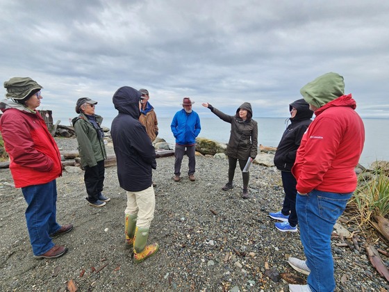
Saturday, October 11th marked a key educational event for Island County, as the newly launched Climate Stewards program embarked on a field trip designed to illustrate the local impacts of sea level rise and increasing storm severity.
Launched by WSU Island Extension in partnership with the WA Climate Education and Extension Team, the Climate Stewards program aims to elevate climate literacy, expand community engagement, and build a resilient future across the state. This field trip was a hands-on extension of that mission, empowering participants to address local climate challenges head-on. The day was led by Kelly Sp̓rk̓ʷaqs Zupich of the Island County Shore Friendly Program, who guided the group through several critical locations demonstrating coastal vulnerability and resilience efforts.
Witnessing the Power of Water
The tour began at West Beach of Deception Pass State Park. Here, the stewards observed the dramatic destruction of a section of the parking lot, the result of a powerful combination of a winter King Tide and a low-pressure storm. The waves had literally peeled up the asphalt, a vivid demonstration of the immense power exerted by water during these extreme weather events.
Discussions at this site highlighted how these intense winter King Tides, when coupled with low-pressure storms and high winds, offer a stark glimpse into the future reality of accelerated sea level rise. Participants talked about the critical need for community-level resiliency planning along marine shorelines, especially as frequent flooding threatens infrastructure and contributes to issues like malfunctioning septic systems.
Resilience Through Restoration
The second stop provided an encouraging look at shoreline recovery: a hard armoring restoration project at Cornet Bay. Stewards explored the site where over 800 feet of creosoted bulkhead had been successfully removed. This major restoration effort has resulted in a more naturally resilient coastline and has significantly improved the habitat for local forage fish species, demonstrating a successful alternative to traditional armoring.
Planning for Vulnerable Communities
The final stop brought the conversation to a low-lying neighborhood that consistently faces challenges during winter storm seasons. Discussions focused on the complex reality of managing property in highly vulnerable areas. This segment underscored a key takeaway of the day: communities must work together to find sustainable solutions for homes and infrastructure that will continue to be impacted by increased flooding.
The field trip successfully provided Climate Stewards with tangible, local examples of the challenges—and opportunities—that lie ahead in protecting Island County's precious marine environments.
If you would like to learn more about how to protect your shoreline property check out the Island County Shore Friendly Program or contact Kelly at k.zupich@islandcountywa.gov
Resource: Upcoming King Tide calendar
Island County's Surface Water Quality team wrapped up sampling for Water Year 2025
Island County's Surface Water Quality team wrapped up sampling for Water Year 2025 (Oct 2024-Sept 2025) and we’re excited to monitor the new rotational sites for Water Year 2026.
Our water quality monitoring program allows us to work on Island County residents’ behalf to:
- Collect water samples to look for health threats
- Post and send out warnings if a problem is identified
- Investigate to identify the source of pollution problems
- Take steps to correct problems
Surface water quality data collected may also be utilized by other Island County departments and external partners to assist with their goals and objectives and to ensure that critical areas are adequately protected. Monitoring the water quality of Island County is essential for protecting overall public health and our community resources.
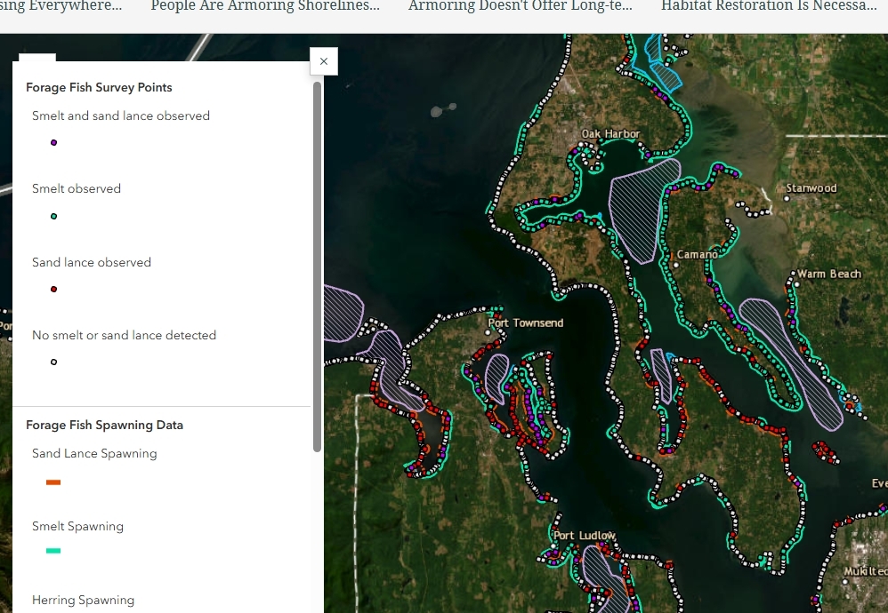
How do we choose our water quality sampling sites? Core monitoring sites are sampled monthly and are usually located at watershed pour points where the fresh surface water meets the Puget Sound. These core sites were chosen to represent a range of watersheds that were either developed, used for agricultural, or had natural land uses. Rotational sites are randomly chosen on a three-year cycle; each site is sampled monthly for one year, and then again in three years. Island County has a mix of core and rotational sites to maximize our funding and sampling efforts.
The map below shows priority watersheds and sampling locations for WY2024-2029. Core and rotational sites are updated with each new 6 yr sampling plan to address changes in land use or new information. Efforts are made to include all major streams and at least one location in all major watersheds. Core sites are located within watersheds that have the most consistent flow throughout the year and are related to sensitive resources such as susceptible aquifers, shellfish beds, swim beaches, and salmon habitat.
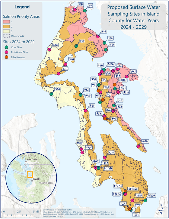
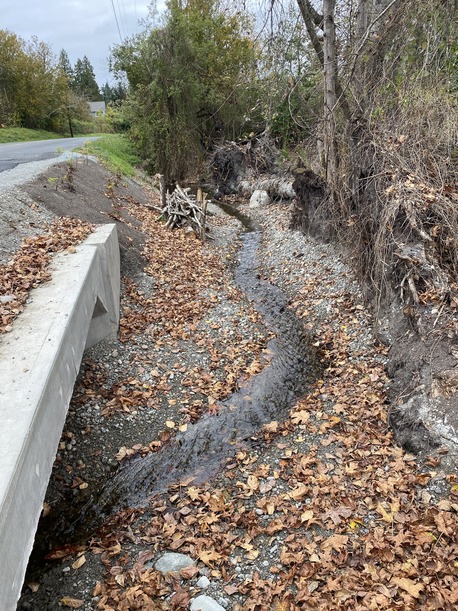
Effectiveness monitoring is another type of monitoring that is used to evaluate the impact of infrastructure modifications (i.e., Best Management Practices (BMPs), Public Works projects, or septic repairs) on water quality. Monitoring is also conducted at potential future project areas where outdated culverts are scheduled to be replaced by fish passage culverts. In areas where there are opportunities to look at the impacts of restoration or development, the goal is to collect and evaluate water quality samples before and after changes have taken place. During WY2025, SWQ staff monitored conditions at several culvert replacements at Chapman Creek and Kristoferson Creek along with restoration areas at Cornet Bay.
All of us live in a watershed, and by working together to prioritize clean surface water in Island County, we can provide a healthier environment for both humans and all living things who rely on these vital natural resources.
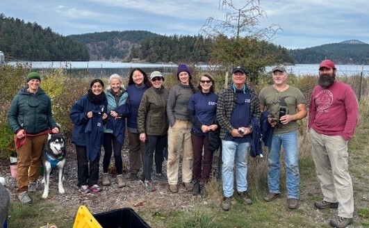
MRC and Northwest Straits Foundation hosted Orca Recovery Day
On Thursday, October 16th, the Northwest Straits Foundation and Marine Resource Committee hosted a native vegetation planting celebration for Orca Recovery Day! Volunteer stewards met at Cornet Bay and Hoypus Point to plant new native vegetation at both restoration sites to support shoreline restoration, overall Salish Sea health, and orca recovery!
November MRC Meeting - November 4th, 2025
Island County Marine Resources Committee (MRC) is an advisory body to county government established in 1999 and comprised of many community volunteers who represent diverse interests and industries, with the common goal to protect and restore marine resources in the Puget Sound area through scientific monitoring, restoration projects, and community education. They hold monthly meetings on the first Tuesday of every month.
The November MRC Meeting will be virtual. To join, please use the Zoom link below:
ZOOM LINK MRC
Questions? Reach out to Elise Adams, (360) 678-7892, E.adams@islandcountywa.gov
PIC Program Community Meetings - December 8th (Maple Grove), 10th (South Holmes Harbor), and 11th (Maxwelton)
The Island County Pollution Identification and Correction (PIC) Program will be hosting community meetings in early December for each of our three focus watershed areas. Please join us as we discuss the important work underway in your community to improve water quality and reopen shellfish harvesting beds! Be on the lookout for additional information and advertisement in the coming weeks. Events will be held on Camano Island for the Maple Grove watershed and south Whidbey Island for the south Holmes Harbor and Maxwelton watersheds.
For more information, please reach out to Quinn Farr, (360) 678-7276, PIC@islandcountywa.gov
** Please note that exact times are still being confirmed and additional information will be distributed in the December newsletter, or on our website at Island County Pollution Identification and Correction (PIC) Program | Island County, WA.
Keep up to do date on social media too! Follow us on Facebook or Instagram.
Get Ready for King Tides!
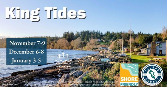
King Tides are the highest astronomical tides of the year and are coming soon! These natural events can bring water levels several feet higher than normal, sometimes causing temporary flooding or erosion, especially when combined with winter storms.
If you live along the Island County shoreline, now is the perfect time to prepare your property and minimize potential risk!
Three Key Steps to Prepare for King Tides
-
Secure Your Outdoors: Move or tie down anything that could float away, such as kayaks, patio furniture, garbage cans, and loose debris. A few feet of high water can easily carry away unsecured items.
-
Inspect and Clear Drainage: Make sure all gutters, downspouts, ditches, and storm drains are clear of leaves and sediment. Allowing rainwater to escape quickly is critical when tide levels are already high.
-
Document and Learn: Use the King Tides as a valuable opportunity! Snap photos of how the water approaches your property and shoreline. This helps us and you understand future sea level rise projections. You can even submit your photos to the MyCoast App.
Resource: Upcoming King Tide calendar
Want expert advice on protecting your home? If you are interested in exploring natural alternatives to hard armoring sign up for a free non-regulatory Shore Friendly site visit today! Shore-Friendly-Program Webpage
Stay informed and prepare your property now to help keep your home and family safe this winter!
Want to strengthen your shoreline or enhance your yard with beautiful, resilient native plants?
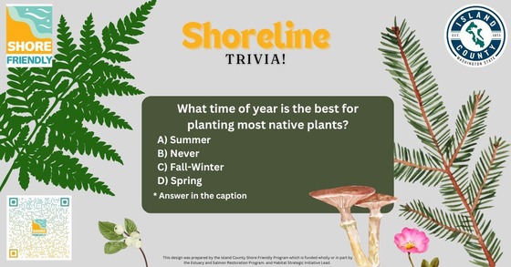 The best time to get them in the ground isn't in the spring—it's right now, during the Fall and Winter! 🌱
In the Pacific Northwest, Fall and Winter planting offers native shrubs and trees the best chance for successful establishment.
Root Establishment: When plants are dormant, they focus all their energy on growing their roots, not their leaves. Planting now gives the root systems months to get established before the stressful heat and dryness of summer arrives.
Natural Watering: The consistent, gentle winter rains provide the ideal amount of moisture. This significantly reduces the need for you to haul out the hose and manually water, saving you time and effort! Erosion Control: For shoreline residents, planting native grasses, shrubs, and trees now allows those roots to start knitting together the soil and stabilizing bluffs throughout the wet season. The longer the plants are established the better protection they can provide.
Action Item: Get your plants ordered and in the ground over the next few months! Check with the local Conservation Districts, they host plant sales annually. Reach out to the Shore Friendly program to get a free non-regulatory site visit to help you develop a custom planting plan for your shoreline.
What IS that?
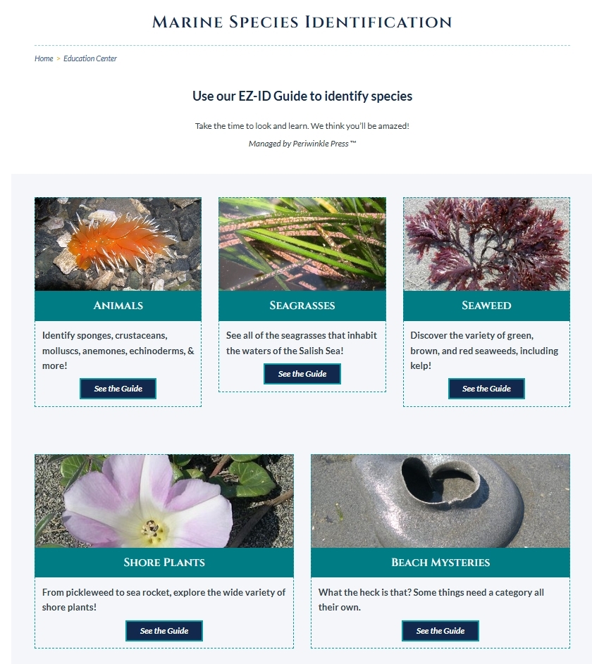
Ever come across something on the shoreline that you just don't recognize or understand? Want to wow your friends and family with how much you know? Head over to the Marine Species Identification page from Sound Water Stewards of Island County. They have an easily navigable database of local marine life here on our shores, including some quite amazing oddities found in Puget Sound...
Visit the website!
|