|
 |
|
DEQ NEWS
|
|
|
|
|
October 15, 2025
|
Vol. 4, No. 9
|
|
|
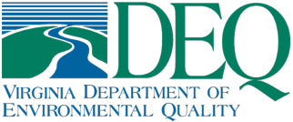
DEQ has streamlined several regulatory barriers that slow down wetland and stream restoration projects. The Commonwealth of Virginia has long supported the restoration of wetlands, streams, and forests as essential strategies for improving water quality, enhancing wildlife habitat, and improving the environment. However, certain state permitting requirements designed primarily to manage development impacts can inadvertently delay permitting for the construction of restoration projects that provide net ecological benefits. To remedy this, DEQ issued a new memo, “Permitting for Surface Water Restoration and Reforestation,” which outlines solutions to streamline stormwater and wetland permitting requirements for these restoration projects.
|
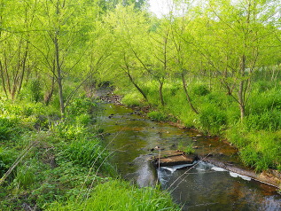
In September, DEQ revised and reissued its 2023 memo, “Agreement in Lieu of a Plan for Farm Buildings or Structures and Associated Impervious Surfaces” to provide clarity on DEQ's interpretation of what constitutes a ‘parcel’ when determining whether the construction of a farm building or structure on a parcel of land with a total imperious cover percentage, including the impervious cover from the farm building or structure to be constructed, is less than 5%.
Where DEQ is the Virginia Erosion and Stormwater Management Program authority or the Virginia Stormwater Management Program authority in a locality, DEQ interprets “a parcel of land” to mean a tract of land, especially a contiguous tract or plot of land in one possession, no part of which is separated from the rest by intervening land in another’s possession. In applying this definition, DEQ will not interpret a public road as breaking the otherwise contiguous property. In addition, DEQ interprets contiguous tracts owned by members of the same family or ownership group as “a parcel of land” for purposes of determining the percentage of impervious cover. If proposed improvements on agricultural land will result in less than 5% total impervious cover for the farm, owners may seek an Agreement in Lieu of a stormwater plan.
|
Land-disturbing activities that pose a de minimis, or low risk, to the environment may now move forward without a full technical plan review. Such projects must meet specific criteria as outlined in DEQ’s new memo, ”De Minimis Plan Review Procedures.” This is not the same as Streamlined Plan Review (see Virginia Stormwater Management Handbook Section 4.3.4). Additionally, the Construction General Permit remains unchanged — coverage and related documentation (e.g., nutrient credit affidavits) are still required.
|

DEQ is seeking public comments until Oct. 20 on Virginia’s tentative “Section 401” Water Quality Certification decisions. Under Section 401 of the Clean Water Act (CWA), federal agencies may not issue a permit or license to conduct any activities that could result in discharges to waters of the United States unless a state Section 401 water quality certification is issued, or certification is waived. States where the discharge would originate are generally responsible for issuing water quality certifications, and they can choose to grant certification, grant certification with conditions, waive certification, or deny certification. Under the CWA, states must act upon 401 certification requests “within a reasonable period of time (which shall not to exceed one year) after receipt".
USACE nationwide permits (NWPs) authorize activities that have minimal individual and cumulative adverse effects on aquatic resources. NWPs authorize a variety of activities, such as installation of waterway aids to navigation, utility lines, bank stabilization, road crossings, stream and wetland restoration, residential developments, commercial shellfish aquaculture, and agricultural activities.
Granting a Section 401 certification or granting certification with conditions for use of NWPs in Virginia expedites the processing of permits while safeguarding Virginia’s environment and reducing duplication of effort by government regulatory agencies to the maximum extent possible. By Virginia issuing a Section 401 certification, applicants would not have to obtain a separate Virginia Water Protection permit or coverage at the time of application.
If finalized, the certifications for this 5-year certification cycle will provide applicants with a more streamlined process to obtain federal and/or state authorizations.
View more information in the full public notice and submit comments to vwppublicnotices@deq.virginia.gov until Oct. 20, 2025.
|
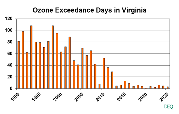
Virginia's ozone forecast season ended on Friday, Sept. 12, 2025. DEQ monitors air quality at 36 locations throughout the state and provides air quality forecasts to ensure Virginians enjoy clean air.
DEQ issues air quality forecasts and health alerts for particulate pollution year-round and for ozone during spring and summer months. Both pollutants can cause a variety of health problems. Ozone, a colorless gas that forms when chemicals in the atmosphere react on hot, sunny days, is most often caused by motor vehicle exhaust, power plants, industrial emissions and solvents. Notably, ozone can travel hundreds of miles from where it forms.
Ozone levels have dropped markedly since ozone monitoring began in the 1970s. In 1993, Virginia experienced a high of 108 high ozone days in at least one locality. In comparison, there were only three high ozone days in 2025.
|
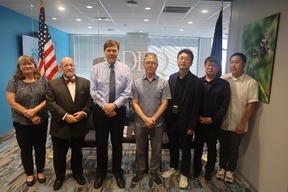
DEQ recently hosted a delegation of water resource managers from the Korea Rural Community Corporation (KRC), a public institution under South Korea’s Ministry of Agriculture, Food, and Rural Affairs. KRC supports stable farm management, promotes the modernization of rural villages and urban/rural exchange, and provides training on farming and water resource management, all of which help to improve the livelihoods of aging farmers and regional agriculture. In addition, KRC specializes in water resource management for agriculture, fisheries, irrigation, water quality, and community-based rural development. Its staff were interested in learning more about water resources and wetlands management in Virginia, due to our shared interest in protecting these resources.
Sang-hyun Kim, Director of the Rural Research Institute; Cheul-Gwan Choi, Deputy Director of the Agricultural Infrastructure Planning Department, and Su-Hong Min, Deputy Director of the Water Quality Management Department, joined DEQ staff to discuss several water management issues, including constructed wetlands for wastewater treatment, wetland mitigation, and drinking water supply. With the help of an interpreter, DEQ’s wetland program experts shared their knowledge of Virginia’s robust wetland protection standards, as well as general information on the Commonwealth’s vast array of wetland and stream classifications. In addition, the visit was followed up with a comprehensive list of references and resources to aide in KRC’s mission back home.
As is customary in South Korea, small tokens of appreciation were exchanged, and professional relationships were formed across continents. DEQ was honored to have been chosen as part of the delegation’s trip to the Commonwealth.
|

As we recently shared, DEQ’s website navigation has now changed based on feedback from more than 1,000 website visitors. An old-to-new URL crosswalk has been posted on our Website Renovation webpage.
|
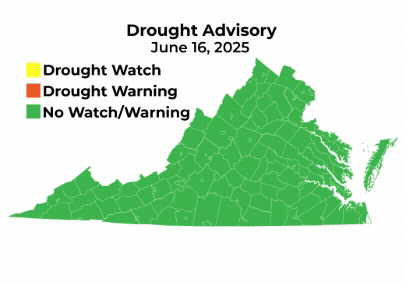
On Sept. 22, DEQ, in coordination with the Virginia Drought Monitoring Task Force (DMTF), established drought watch advisories for 28 counties in Northern Virginia, the Shenandoah Valley, and the south central portion of the state. On Oct. 2, the DMTF met and maintained these advisories.
A drought watch advisory, intended to help Virginians prepare for a potential drought, was issued for the following areas:
- Northern Virginia: Arlington, Fairfax, Fauquier, Loudoun, and Prince William counties
- Roanoke River: Bedford, Campbell, Charlotte, Franklin, Patrick, Halifax, Henry, Mecklenburg, Pittsylvania, and Roanoke counties
- Upper James: Alleghany, Bath, Craig, Botetourt, Highland, and Rockbridge counties
- Shenandoah: Augusta, Clarke, Frederick, Page, Rockingham, Shenandoah, and Warren counties
Although parts of Virginia recently received significant rain, the previous relative lack of precipitation has resulted in rapid declines in streamflow and groundwater levels, ranging from the northern portion of the Commonwealth, south along the Blue Ridge, to the south-central region of the state. The Drought Monitoring Task Force met again on Oct. 14 to reevaluate conditions.
DEQ continues to work with local governments, public water works, and water users in the affected areas to ensure that conservation and drought response plans and ordinances are followed. Localities and residents that are supplied water from the Potomac River should consult the Metropolitan Washington Water Supply and Drought Awareness Response Plan for specific triggers and actions to be taken. All Virginians are encouraged to protect water supplies by minimizing water use, monitoring drought conditions, and detecting and repairing leaks.
See the current drought status on the DEQ website.
|
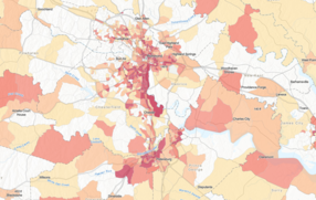
The Virginia EJScreen+ mapping tool has been updated with newer census and environmental data. This mapping tool provides access to environmental justice-based information data layers and community outreach resources based on the Virginia Environmental Justice Act.
The tool can be used to compare environmental and demographic information throughout the state and can help identify communities that may qualify for additional consideration, engagement, or analysis during public participation and engagement opportunities.
Updated resources include census population data and improved clarification on how the low-income and communities of color layers are defined. The tool also includes layers for community outreach resources, Tribal contact information, and updated air and water quality monitoring location data.
|

DEQ has launched its Virginia Excess Food Opportunities Map to support the Food Rescue and Composting Subaward Program, which will fund 15-20 three-year grants totaling $8.8 million to support the reduction of food waste. The map includes available data layers that are relevant to food waste prevention, food rescue, and composting in Virginia.
The map includes information about municipal compost programs, farmers markets, community gardens, and other groups who are engaged in food waste prevention, food rescue, and composting. Those interested in food waste prevention can use this tool to explore resources in their area.
The map will continue to be updated as new information becomes available.
Colleges, universities, and state agencies are now able to apply to the Food Rescue and Composting Subaward Program. Applications must be submitted by November 17.
|
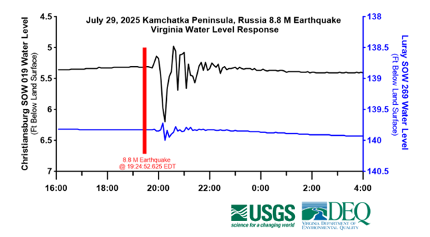
Did you know that the recent 8.8 magnitude earthquake in Russia was detected as far away as Virginia’s groundwater monitoring wells? Teleseismic groundwater-level oscillations are groundwater responses to large, often distant earthquakes and can generally only be observed in a small number of wells that are drilled into bedrock. Only a handful of Virginia’s 206 real-time state observation wells, used to monitor aquifer conditions and support resource management decisions, pick up teleseismic oscillations.
One of the most sensitive and famous teleseismic wells in the nation happens to be in the Town of Christiansburg in southwest Virginia. The former water supply well, now part of the state’s observation well network, was drilled through 450 feet of limestone bedrock. Teleseismic oscillations have been observed in this well since the late 1960’s when the state began collecting continuous water level readings, but it wasn’t until 2007, when the well was outfitted with real-time satellite-based data collection and transmission equipment, that the oscillations could be precisely correlated to global earthquake data.
The network of bedrock fractures that the Christiansburg well passes through is sensitive to seismic waves that are caused by earthquakes greater than 6.0 magnitude. Oscillations in the well usually start approximately 20-45 minutes after an earthquake starts and can last almost an hour. During these events the water level in the well vibrates and rapidly moves up and down by as much as 5 feet, as shown in this video captured by DEQ in 2012.
As shown below, oscillations in the Christiansburg well began 31 minutes after the 8.8 magnitude Kamchatka Russia earthquake and lasted almost 3 hours, and was covered by WVTF Roanoke. DEQ is expanding its observation well network in western Virginia, and a newly completed observation well in Luray, which passes through a water-filled cave at 494 feet, has shown similar teleseismic behavior.
|
In a continued effort to improve the efficiency of regulatory reviews, DEQ and the U.S. Army Corps of Engineers have shortened the target schedules for agency review for certain credit releases under their updated Memorandum of Agreement for the implementation of the third-party compensatory mitigation program. In instances where complete reports and credit release requests are received, the updated agreement shaves 30 days from the target schedules for as-built report credit releases and monitoring report credit releases. Read more in the joint letter issued by DEQ and the U.S. Army Corps.
|
|
|
|
Visit the DEQ website for comment opportunities on pending enforcement orders and permit actions. The following regulatory actions are available for public comment:
- Proposed Regulatory Action - Solid Waste Management Regulations (9VAC20-81) - Amendment in response to Chapter 235 of the 2024 Virginia Acts of Assembly; comment by Oct. 24
- Proposed Regulatory Action - Virginia Water Protection General Permit for Impacts Less Than One-Half Acre (9VAC25-660) - 2026 Reissuance of General Permit - 9VAC25-660; comment by Oct. 24
- Proposed Regulatory Action - Virginia Water Protection General Permit for Facilities and Activities of Utility and Public Service Companies Regulated by the Federal Energy Regulatory Commission or the State Corporation Commission and Other Utility Line Activities (9VAC25-670) - 2026 Reissuance of General Permit – 9VAC25-670; comment by Oct. 24
- Proposed Regulatory Action - Virginia Water Protection General Permit for Linear Transportation Projects (9VAC25-680) - 2026 Reissuance of General Permit – 9VAC25-680; comment by Oct. 24
- Proposed Regulatory Action - Virginia Water Protection General Permit for Impacts from Development and Certain Mining Activities (9VAC25-690) - 2026 Reissuance of General Permit – 9VAC25-690; comment by Oct. 24
In addition, there are numerous DEQ meetings and general comment periods where you can stay up to date on topics of interest:
-
Public Briefing – Air and Solid Waste Permits – Green Ridge Landfill; Oct. 15 at 6 p.m. at Cumberland County High School, 15. School Rd., Cumberland
-
Virginia Litter Control and Recycling Fund Advisory Board; Oct. 22 at 10 a.m. at DEQ Piedmont Regional Office
-
Public Hearing – Virginia Water Protection Permit – Southeast Supply Enhancement Project in Pittsylvania County; Oct. 22 at 6 p.m. at The Institute for Advanced Learning and Research, Barkhouser Auditorium, 150 Slayton Ave., Danville
-
Public Hearing – Virginia Pollutant Discharge Elimination System (VPDES) Permit – Waterford Wastewater Treatment Plant; Oct. 23 at 6 p.m. at Board of Supervisors Meeting Room, 11282 Government Center Dr., Orange
-
Public Hearing - Transco Eden Loop Project - Tentative Upland 401 Water Quality Certification; Oct. 23 at 6 p.m. at The Institute for Advanced Learning and Research, Danville
-
Public Meeting – Total Maximum Daily Load Cleanup Study for Wolf Creek in Washington County; Oct. 28 at 3 p.m. at DEQ Southwest Regional Office, 355-A Deadmore St., Abingdon
-
Public Hearing – General VPDES Watershed Permit Regulation for the Total Nitrogen and Total Phosphorus Discharges and Nutrient Trading in the Chesapeake Bay Watershed; Nov. 10 at 10:30 a.m. at DEQ Piedmont Regional Office
|
|
|
Are you committed to protecting human health and the environment?
Apply for a job at DEQ. Current openings include:
-
Stormwater Compliance Specialist (Oct. 16; Richmond)
|
|
|
|
|
