Vision Zero in Arlington County -- July Updates
Arlington County VA Government sent this bulletin at 07/13/2021 03:25 PM EDTLea este correo electrónico en español.
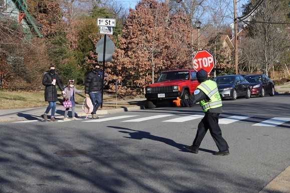
We need crossing guards! Apply now or help spread the word!
The Arlington County Police Department has multiple openings for Arlington Public Schools (APS) crossing guards. There is currently a shortage and we have a growing list of locations that need coverage.
Crossing guards typically work 12.5 hours per week, Monday through Friday. Hours and locations are determined by APS’s needs and schedules. To learn more and to apply, visit here!
To help spread the word, please share this opportunity within your community!
County Proposes Speed Limit Reductions on Seven Major Arlington Corridors
The Vision Zero Action Plan’s Speed Management Action Item is off and running! State Code authorizes local governing bodies to enact and enforce ordinances to raise or lower speed limits within their boundaries, provided change is based upon a traffic engineering investigation. The Department of Environmental Services conducted a study on each of the following corridors and recommended the following changes to be voted on by the County Board at its July 17 meeting:
1. Army Navy Dr from S Joyce St to 12th St S (from 35mph to 25mph)
2. Army Navy Dr from 25th St S to S Joyce St (from 30mph to 25mph)
3. Kirkwood Rd from Lee Hwy to Washington Blvd (from 30mph to 25mph)
4. Yorktown Blvd/Little Falls Rd from 26th St N to Williamsburg Blvd (from 30mph to 25mph)
5. S Eads St from S Glebe Rd to 24th St S (from 30mph to 25mph)
6. S Eads St from Army Navy Dr to 15th St S (from 30mph to 25mph)
7. 15th St S from S Hayes St to Richmond Hwy/US Rt-1 (from 30mph to 25mph)
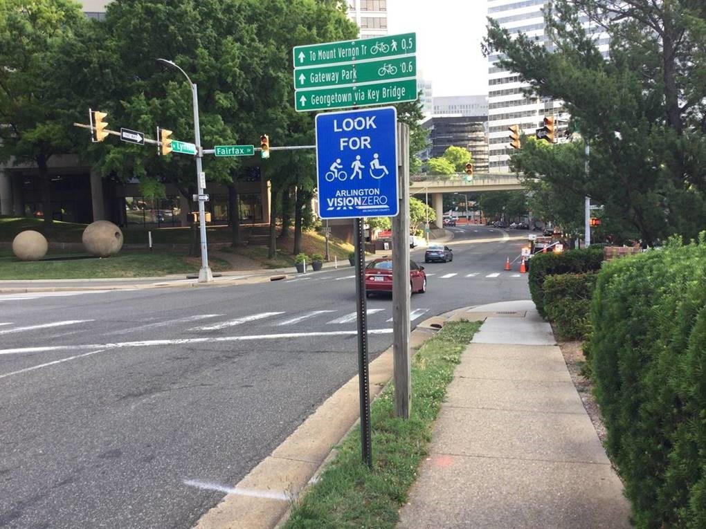
Vision Zero Signage Takes to the Streets
Vision Zero is about creating a community culture of safety—which starts with education. We installed Vision Zero signage on various County-maintained corridors this month. The signs are located on High-Injury Network corridors and at key entrance points to the County. There are two types: (1) “Look for Pedestrians and Bikes” signs entering areas with high pedestrian and bicycle activity; and (2) “Slow Down” signs entering corridors with a history of speed-related crashes. This type of signage is just the start of the Vision Zero communications and engagement work to get people to think “safety-first” as they drive, walk or roll.
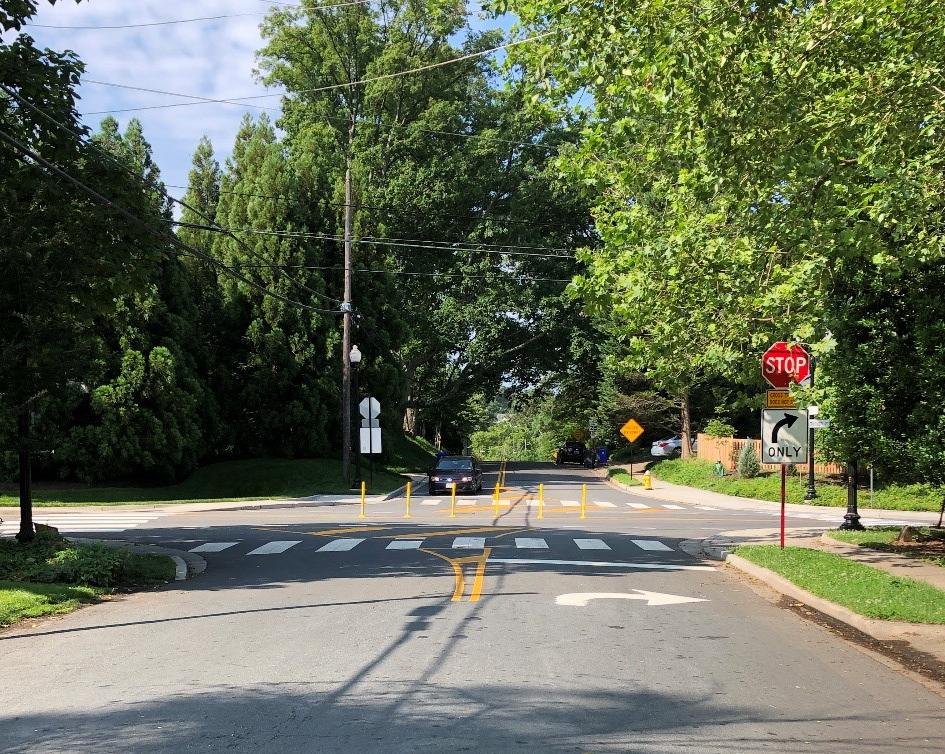
Permanent Turn Restrictions at Little Falls Road and Old Dominion Drive
The intersection of Little Falls Road and Old Dominion Drive is a crash hot spot location that Arlington County staff, in coordination with the Virginia Department of Transportation (VDOT), have been working to make safer. While the County works to identify funding for a long-term safety solution (such as a traffic signal), we’ve implemented short-term, quick-build solutions to address ongoing angle crashes. In 2020, the County installed signs restricting left and thru movements from the Little Falls Road approach during peak travel hours, but these restrictions did not reduce crash frequency. In 2021, County staff coordinated with VDOT to make the left and thru restrictions permanent and adding barriers to prevent vehicles from making the restricted movements. County staff will continue to monitor this location and pursue long term solutions moving forward.
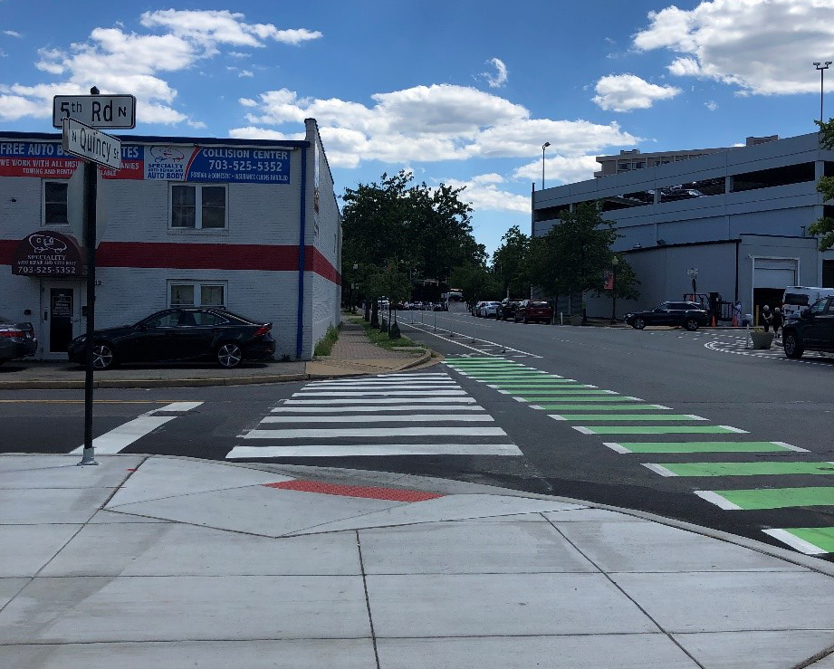
Final Link in North Quincy Street Protected Bike Lane Complete
In 2018, Arlington County installed a protected bike lane on North Quincy Street from Glebe Road to Wilson Boulevard during a repaving project. At the time of the installation, a section of the bike lane along the Mosaic Park site was not protected because of upcoming curb and gutter work to be installed as part of park construction. Now that the Mosaic Park project is complete, we were able to finish the protected bike lane on the east side of North Quincy Street and mark the bike lane across the intersection using green bicycle markings.
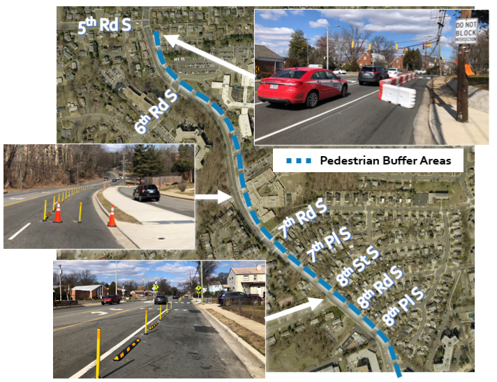
South Carlin Springs Pilot Engagement: Tell Us What You Think!
The South Carlin Springs Walkability Improvements pilot project temporarily repurposed the northbound right travel lane of South Carlin Springs Road from 8th Place South heading north to 5th Road South using bollards, wheel stops, barriers and traffic barrels. This area has narrow sidewalks and little or no pedestrian buffer. The County identified safety needs on this corridor through the 2017 hot spots program and collaboration with Arlington Public Schools in 2017.
The pilot, installed in March 2021, intended to create a safer walking path for students accessing Campbell Elementary School, Carlin Springs Elementary School and Kenmore Middle School by: (1) narrowing crossing distance at intersections to improve safety and accessibility for people walking and biking cross South Carlin Springs, and (2) providing additional buffer space to improve walking and biking conditions on the corridor. We are now looking for feedback on the pilot project to help identify next steps. Share your thoughts by July 21.
(información en español | comentarios en español | መረጃ በአማርኛ | አስተያየት በአማርኛ)
Share Your Experiences with Arlington Families for Safe Streets
Arlington Families for Safe Streets (Arl FSS, a local organization committed to advancing Arlington’s Vision Zero safety goals) is looking for your input on a new Near Miss Location Survey, which allows community members to report close calls or safety concerns on streets and trails. Northern Virginia FSS chapters review the community concerns reported through the survey and share their findings with local jurisdictions and organizations.
This video explains how to complete the survey. You may submit your data anonymously or opt-in for follow up. Arl FSS asks that you spread the word on neighborhood listservs and with anyone who would be interested.