|
Get outside, have fun, and do some science!
Up for a treasure hunt? Looking for something fun to do outside? With Bench Mark Hunting you can do both, and maybe even contribute some new information to the Nation’s oldest civilian science agency!
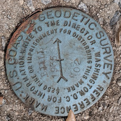
National Geodetic Survey (NGS) and our predecessor agencies have used many different types of survey marks during the 215 years we’ve been providing the precise spatial framework for surveying and mapping in the United States. Survey marks are permanently placed, and stable objects that have precisely determined spatial reference coordinates, such as latitude, longitude, and heights. You can think of these marks as the “pins” connecting maps, charts, images, and models to specific locations on the Earth’s surface. Once you know to look for these marks, you will begin to see them everywhere, but for most people they remain hidden, as part of our Nation’s invisible, yet critical, geospatial infrastructure.
Get Involved!
Bench mark hunting can be a great way to engage family and friends, enjoy the outdoors, and even help recover survey marks! Just make sure you respect private property, avoid dangerous areas, and obey local laws.
Participate in 3 easy steps:
- Use the NGS Map to search for marks to find in your area of interest.
- On the map, click on a mark and then look at the NGS Datasheet for the marks you want to find. The clues to the treasure hunt to find the mark are at the bottom of the page in the Station Description and Station Recovery sections.
- Once you get out there, report what you find - Submit photos and a Mark Recovery Report to NGS!
For lots of great information, check out the Bench Mark Hunting section of Geocaching.com, but don't forget to send your recovery reports directly to NGS.
Whether or not you participate in any geocaching activities on August 20, bench mark hunting is something you can tell people about or do in the future. NOAA and NGS would love to hear about activities in your community:
For a fascinating history and lots of great examples of Survey Mark Art check out: Bottles, Pots & Pans? - Marking the Surveys of the U.S. Coast and Geodetic Survey and NOAA, By CDR George E. Leigh, NOAA Corps (Ret’d.).
|

There are common themes in both geocaching and NGS’ GPS on Bench Marks (GPSonBMs) effort: crowd-sourced data sharing and mark recovery.
Participating in GPSonBMs will help your community prepare for the modernized National Spatial Reference System. To understand about potential intersections with geocaching, learn more about the GPSonBMS program online:
|
|