GPSonBM Campaign Cut-Off Date Extended
This extension reflects the NGS commitment to include as much local data as possible in determining the Reference Epoch Coordinates (REC) that will be used to create the Transformation Tools that will be released with the Modernized NSRS. This will allow users to transform their data between current vertical datums and NAPGD2022, the new geopotential datum being developed for the Modernized NSRS.
This extra time will allow participants to use the recently released beta version of OPUS Projects 5.0 to submit a series of much shorter RTK or RTN observations using GVX, the GNSS Vector eXchange file format. Major geospatial software providers are beginning to enable users to export their survey data in GVX format for use in OPUS Projects. Check for recent updates to your survey software or talk to your vendors to see if your software supports GVX export.
While OPUS Projects 5.0 is being beta tested, users will be able to try out all of the functionality and processing workflows but will not be able to submit their surveys to NGS. However, all users who load data into OPUS Projects will be given an opportunity to complete the bluebooking process and submit the data to NGS for use in the transformation tool after the beta testing period is complete.
Recent Progress
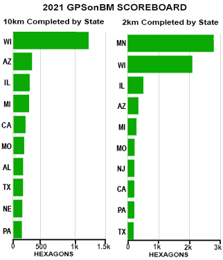
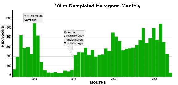
Data submissions through OPUS have continued at a strong pace, even after the summer rush. With the extension of the cut-off date through 2022, we anticipate that more people in more parts of the country will make the time to collect and submit data and continue to fill remaining gaps in coverage. Astute observers may notice some changes in our progress reporting in the graph and the 2021 Scorecard below.
Thanks to questions from a partner in Wisconsin who does monthly reporting on their GPSonBM activity, we were able to identify an inconsistency in the way that our code accounted for new data and assigned dates to closed hexagons on our web map. This issue did not affect the overall number of completed hexagons or the marks that have been listed as priority marks. It only affected the date marks were assigned as completed. Fixing this has moved the completion date for a number of hexagons to an earlier occupation. Rest assured that no matter when the hexagon was “completed,” all data submitted to NGS will be considered for use in the 2020.00 Reference Epoch Coordinate adjustment and the subsequent creation of the transformation grids.
|
 |
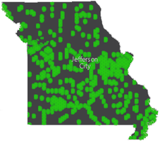
Partner Highlight: Missouri
This week the Census Bureau announced that
the Center of Population for the 2020 Decennial Census is near Hartville, Missouri. Every decade since 1960 NGS has worked with Census to place a survey mark at or near the coordinates calculated by Census as the Center of Population. I’m glad to report that in April 2022, NGS and Census, in collaboration with Missouri partners, will again unveil a commemorative survey mark and celebrate the heart of America. While the official definition for the Center of Population is a bit esoteric, I find the idea of a place where our Nation is balanced and everyone is given an equal weight, to be quite inspirational.
I’d like to take this opportunity to send a well deserved shout out to our GPSonBM partners in Missouri, particularly at the Departments of Agriculture and Transportation, who have stepped up this year to collect and share GPSonBM data across the state. While the state has only completed 38% of the 10 km hexagons so far, much of that data has come in this year and it is well distributed around the state. In Spring of 2022, 88 years after US Coast and Geodetic Survey leveling crews walked through Hartville surveying level line L1691, NGS will collaborate with local partners on a GPS survey to put official coordinates on the new mark in Hartsville. This survey and the related federal, state, and local cooperation is an important example of how we are working together to build the bridge to the future and getting our nation ready for the benefits that will come with the Modernized NSRS.
|
Looking forward to 2022

- Join us on January 13th, 2022 at 2 pm eastern for a presentation on this extension. It’s part of the NGS Webinar Series, registration is open, and it will be a great way to kick off the new year of GPSonBM data collection
- Start thinking outside the box about innovative partnerships and opportunities to collaborate with other geospatial professionals and businesses in your region (hint: Surveyors Week in March). Together, we can do more than any of us can do on our own!
|
NGS tracks participation in this campaign, but we rely on partner participation to be successful. If you have an accomplishment you want to highlight, email NGS.GPSonBM@noaa.gov.
|