Map of Papahānaumokuākea Marine National Monument showing the original and expanded boundaries. Image: NOAA
View PMNM map poster.
On Friday, August 26, 2016, President Barack Obama signed a proclamation expanding Papahānaumokuākea Marine National Monument.
Previously the largest contiguous fully-protected conservation area in the United States at 139,797 square miles, the expanded boundaries made it one of the largest protected areas on the planet at 582,578 square miles, nearly the size of the Gulf of Mexico.
In the five years since expansion, research, exploration and discoveries have brought the world's attention to the expanded areas of this special place. Some noteworthy stories are listed below.
Read about the expansion announcement
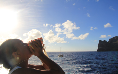
Image: A Native Hawaiian cultural practitioner sounds the pū (conch shell trumpet) to announce the arrival of the traditional voyaging canoe, Hikianalia, at Nihoa Island (Credit: Jamie Makasobe).
Download the poster
Image: Deep water resources of Papahānaumokuākea poster (Credit: NOAA).
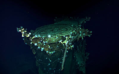
Learn about discovery of long-lost wreckage from the Battle of Midway
Image: Kaga gun mount (Credit: R/V Petrel/Vulcan Inc).
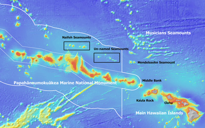
Explore seamounts
Image: Map showing area (outlined in black) within Papahānaumokuākea Marine National Monument that was surveyed during the expedition. White lines show original and expanded boundaries of the Monument (Credit: Chris Kelley/University of Hawaiʻi).
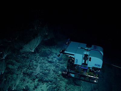
Discover deep water habitats: deep sea corals and sponges
Image: Okeanos Explorer's ROV Deep Discoverer surveys a deep-water coral assemblage at 2000 m during an expedition to PMNM in 2015 (Credit: NOAA/OER).
Read the NFWF report
In 2021, Hawaiʻi and the nation commemorate the 15th anniversary of the Monument’s designation and the 5th anniversary of its expansion. This report celebrates some of the projects and collaborations that are working to understand and preserve this special place held in the public trust.
Image: National Fish and Wildlife Foundation 2020 Program Report cover (Credit: NFWF).
Enjoy new species
Image: Famed undersea explorer Sylvia Earle presents President Obama with a picture of the fish that bears his name during his visit to Midway Atoll in September 2016 (Credit: Brian Skerry/National Geographic, while filming "Sea of Hope: America's Underwater Treasures").
“Five years ago I had the privilege of joining President Obama on Midway Atoll to celebrate his actions in quadrupling the size of the Papahānaumokuākea Marine National Monument.
Time flies, as they say, and that is the problem. It took this planet 4.5 billion years to get to where we are today – the sweet climactic sweet spot which allowed civilization to flourish. But in just the last 4.5 decades, we humans have started to undo what nature has evolved for our benefit.
We now know what we did not know 40 years ago and we no longer have any excuse. Time is not on our side and we must act urgently to turn the tide. This is why Papahānaumokuākea is so special. It is a rare example of the opportunity to reverse the damage we have caused as we learn to apply the principles of Aloha ʻĀina – that everything is connected.”
Deeply,
Dr. Sylvia Earle
Mission Blue
Mahalo for your support!
|