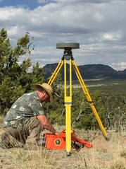
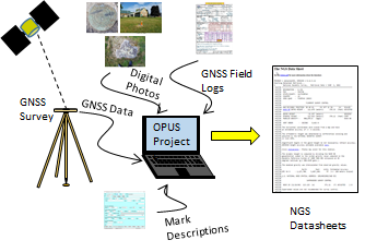
The National Geodetic Survey's Online Positioning User Service (OPUS) now provides an efficient path for users to submit static, campaign-style GNSS observations to establish local survey control. The latest version of OPUS Projects now creates all of the "bluebook" files required to submit observations to NGS. After NGS has reviewed and accepted these observations, it adds new, official coordinates to the National Spatial Reference System (NSRS) and distributes these via NGS datasheets. In this way, users can easily establish survey control where they need it, while filling important data gaps and maintaining the entire system.
|
Learn More: What is OPUS Projects?
This video provides an overview of what this tool can do, and can help you decide whether you want to take OPUS Manager training.
The recorded NGS webinar, OPUS Adds New Functionality describes recent OPUS Projects capabilities in greater detail.
What to Expect
If you've been using Beta OPUS Projects:
The Beta site has been closed. Active projects on Beta have been copied over to the Production site. You can now only access your active projects on the OPUS Projects site using the same ID and keywords (unless you received an email from NGS that your project ID was changed due to conflicts).
If you've been using OPUS Projects:
You will see new features appearing on your existing project, including the ability to associate an NGS Project Tracking ID to your OPUS Projects.
For more information, contact the OPUS Help Desk at NGS.OPUS@noaa.gov.
|
|