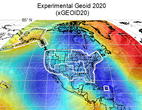
NGS has released xGEOID20 - the foundation for determining precise heights in the modernized National Spatial Reference System (NSRS). The geoid takes the shape of the ocean surface if the other influences such as winds, tides and ocean currents were absent. This surface is extended through the continents and it is computed through the gravimetric method. The xGEOIDs provide a preliminary - but increasingly accurate - view of the changes expected from modernizing the NSRS and replacing the North American Vertical Datum of 1988 (NAVD 88).
Experimental Geoid Model 2020 (xGEOID20) is the first joint experimental geoid model produced through international cooperation between the United States, Canada, and Mexico. It incorporates the latest satellite gravity model, all available airborne gravity data from the GRAV-D program (Gravity for the Redefinition of the American Vertical Datum), improved digital elevation model (DEM) in 3” spatial resolution. It provides the geoid accuracy and an updated dynamic geoid model of changes over time. For more information, please contact the NGS geoid team.
|