Campaign Countdown

NGS is building a 2022 Transformation Tool, which will enable conversions from current vertical datums to the North American-Pacific Geopotential Datum of 2022 (NAPGD2022) and will be integrated into the NGS Coordinate Conversion and Transformation Tool (NCAT).
NGS will build the transformation tool with data submitted within the next 13 months, by December 31st, 2021. This deadline applies to both data for the computation of 2020.0 Reference Epoch Coordinates (RECs) and subsequent use in creating the 2022 Transformation Tool. By necessity, NGS will interpolate over areas without GPSonBM data, meaning the transformations will be less accurate in those areas.
|
Recent Progress
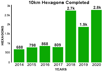
The volume of crowd sourced GPSonBM data has remained strong over the past three years. In fact, 2020 just surpassed the record breaking number of contributions in 2018 when we were focused on collecting data for use in GEOID18.
We have set an ambitious data submission target for the Transformation Tool Campaign, and as of this update, over 20% of the prioritized marks have been observed. Check out the GPSonBM Progress Dashboard where recent upgrades have made it easier to look at state by state progress and to view data submission rates over time.
|
Partner Highlight: New Jersey

This month, we are pleased to highlight New Jersey as the first State to complete 100% of the 10 km hexagons covering their state! With nearly as many OPUS Share submissions in 2020 than in 2018 and 2019 combined, the New Jersey Geodetic Survey led the effort to systematically recover, observe, and submit the necessary data on suitable bench marks in all 251 of the 10 km hexagons covering the state.
In fact, NJGS has also made significant progress toward collecting data on the 2km marks as well (over 50% complete), which will improve the local performance of the transformation model by capturing more of the geographic variance in the relationship between NAVD 88 and the gravimetric geoid model.
|
Call to Action: Recover, Observe, Report!

On both the GPSonBM Web Map and the Progress Dashboard, we use hexagons to illustrate the geographic areas where new GPS data on specific bench marks will improve the transformation tool. When we have the data we need on a bench mark, we turn the associated hexagon green to show that area as complete. As of this update, we have completed 10,565 marks. Let's shoot to reach 11,000 completed marks - turning more hexagons green - across the country by the end of 2020!
|
NGS tracks participation in this campaign, but we rely on partner participation to be successful. If you have an accomplishment you want to highlight, email NGS.GPSonBM@noaa.gov.
|