|
NGS Releases Technical Report and Web Map for GEOID18
NGS has released NOAA Technical Report NOS NGS 72–GEOID18, a comprehensive explanation of the data and methods used to create the latest NGS hybrid geoid model, and the GEOID18 Exploratory Web Map, a web map that allows users to visualize and analyze the GPS on Bench Marks dataset at the heart of the model.
GEOID18 would not be what it is without the thousands of hours that many volunteer surveyors, state and local agencies, and federal agency partners put into collecting GPS data on bench marks. NGS sincerely thanks all the people who participated in data collection over the past few years and who have helped create GEOID18.
The report provides details on the state-by-state and regional analyses performed on over 36,700 survey control points, where NGS had the GPS, gravity, and geodetic leveling data required to build GEOID18. It explains how the data collected on these points, known as GPS on Bench Marks (GPSonBM), were used to filter and weight the observations that were included in the GEOID18 model. Topics covered in the report include:
- Technical specifications of the model
- Descriptions of input data
- Methodologies used
- Evaluation metrics
- Model performance
|
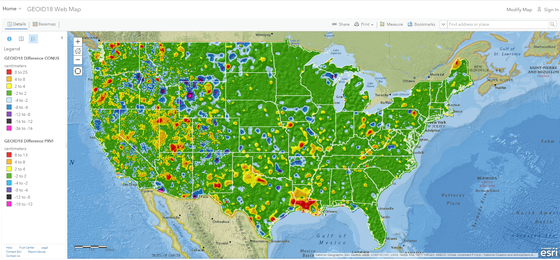
The GEOID18 Exploratory Web Map allows users to explore the model’s differences from GEOID12B, and where improvements were made, including where data gaps were filled and where old data were updated with new, crowd-sourced observations. The new map also allows users to
- Visualize GEOID18 height values
- Estimate the uncertainty in the model in any given area of interest
- Investigate the data available for each GPSonBM point considered for the model and the metrics used to evaluate it
NGS values your opinion about how we are meeting your geodetic needs. Tell us what you think about the GEOID18 Technical Report and the Web Map at ngs.feedback@noaa.gov
|