|
NGS Releases Technical Report and Web Map for GEOID18
NGS has released NOAA Technical Report NOS NGS 72–GEOID18, a comprehensive explanation of the data and methods used to create the latest NGS hybrid geoid model along with an exploratory web map that allows users to visualize and analyze the GPS on Bench Marks dataset at the heart of the model.
The NGS geoid models are the authoritative United States reference models for surveying and mapping professionals to convert GPS-derived ellipsoid heights to orthometric heights in NAVD88 and island height datums such as PRVD02. GEOID18 was released in September 2019 and is the last hybrid geoid model that NGS will create before the transition to the purely gravimetric geoid models that will serve as the foundation of the modernized National Spatial Reference Systems in the coming years.
GEOID18 Technical Report
NOAA Technical Report NOS NGS 72–GEOID18 describes in detail the technical specifications of the model, input data, methodologies used, evaluation metrics, and model performance. The report relates the state-by-state and regional analyses performed to compare the GPS, gravity, and geodetic leveling data available to NGS and how this information was used to filter and weight the data points that were included in the model.
GPS on Bench Marks (GPSonBM) is the NGS crowdsourcing approach for working with federal and state government agencies, universities, and private sector firms to find and report back on existing NGS survey control marks and collect and share survey-grade GPS data on a prioritized list of marks that will provide the most benefit for improving the local accuracy of national scale models and tools that NGS builds to serve the nation. GEOID18 boasts significant improvements over the previous NGS model, GEOID12B, primarily due to the use of the GPSonBM crowdsourced data.
|
The Acknowledgements section of the Technical Report recognizes the tremendous contribution of the partners in this crowdsourced effort::
“GEOID18 would not be what it is without the many hours that thousands of volunteer surveyors, state and local agencies, and federal agency partners put into collecting GPS data on bench marks. NGS sincerely thanks all the people who participated in data collection over the past few years and who have helped create GEOID18.”
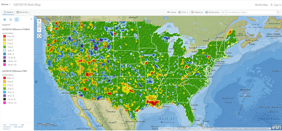
GPSonBM Exploratory Web Map
The GEOID18 Web Map allows users to explore the crowdsourced GPS on Bench Mark observations that were used to create GEOID18. The map allows users to visualize geoid heights, where improvements in the model were made, estimate the uncertainty in the model in their area of interest, and explore the differences from GEOID12B. For the previous hybrid geoid models, users could only view static maps or download the data, so this new interactive web map provides a significant improvement that allows users to explore the data or integrate the map layers into their own web maps.
The datafile for all GPS on Bench Mark data points considered for use in GEOID18 has been archived by NOAA NCEI and can be accessed via the digital object identifier # & link.
Let us know what you think about our new maps and dashboards:
email us at ngs.feedback@noaa.gov
|