NGS Releases Annual Experimental Geoid Models

Having trouble viewing this email? View it as a Web page.


NGS Releases Annual Experimental Geoid Models

xgeoid19 map


Release Details


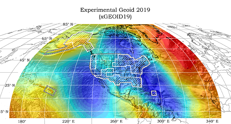
NGS has released its annual experimental geoid models xGEOID19. The geoid is an equipotential surface of the Earth’s gravity field, closely related to global mean sea level, that is the foundation for measuring precise heights.


Experimental Geoid Model 2019 (xGEOID19) is available in:

  • North America and Pacific Region(CONUS, AK, HI and PRVI)
  • Guam and Northern Mariana Islands
  • American Samoa

Related product releases include: 

  • Experimental Deflection of the Vertical 2019 (xDEFLEC19) The deflection of the vertical is used to relate the orientation of a locally leveled instrument to a spatial reference system.  

  • Experimental Dynamic Geoid 2019 (xDGEOID19). The dynamic geoid model includes a time-dependent component” that will reflect monitored geoid changes over space and time.


In Case You Missed It

new datums


Starting in 2014, NGS began publishing a series of experimental geoid (xGEOID) models annually. The experimental models utilize:


The xGEOIDs provide a preliminary but increasingly-accurate view of the changes expected from the scheduled 2022 release of the North American-Pacific Geopotential Datum of 2022 (NAPGD2022). This new geopotential datum will replace the North American Vertical Datum of 1988 (NAVD 88).

Learn More

Watch Videos

  • What's Next for Geodetic Datums? Watch this five minute video to remind yourself of NGS' plans to modernize the NSRS along with the importance of preparing now to adopt these new datums. 
  • What is the Geoid Monitoring Service (GeMS)? Watch the recording of our September 12th webinar to learn about this project and how you might begin to see attributes in NGS products and tools.

Further Reading