|
Beta Release: Improved Vertical Datum Transformations Now Available
Currently, NGS defines seven orthometric vertical datums for the United States and its territories. There are also historical or superseded national vertical datums that may be of interest when referencing historical information. NGS provides and continues to improve tools to transform coordinates between many vertical datums.
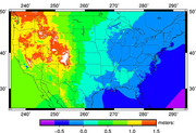
NGS has just released VERTCON 3.0 for beta testing. It is integrated into the NGS Coordinate Conversion and Transformation Tool or (NCAT) Version 2.0, which is also available for beta testing. Both of these releases provide improved and new vertical datum transformations for users.
Send comments to ngs.feedback@noaa.gov.
NCAT 2.0 now uses VERTCON 3.0 release 20190601 grids to support:
-
transformations between the National Geodetic Vertical Datum (NGVD 29) and the North American Vertical Datum of 1988 (NAVD 88) in CONUS and Alaska.
- transformations for vertical datums on Pacific and Caribbean islands.
When using these tools, please note:
- This VERTCON 3.0 release and update to NCAT 2.0 will ultimately fully replace VERTCON 2.1.
- Currently, NCAT only supports orthometric-to-orthometric and ellipsoidal-to-ellipsoidal height transformations.
-
Currently, NCAT does not transform between orthometric and ellipsoidal heights.
Send comments to ngs.feedback@noaa.gov.
|
|