Innovative Model Improves Stock Assessments
The Woods Hole Assessment Model, or WHAM, is our innovative state-space fisheries assessment model. We use it to evaluate the abundance of fish stocks such as Atlantic herring, black sea bass, and Acadian redfish. By using this model, our scientists can incorporate environmental conditions and better estimate scientific uncertainty. This improves our understanding of the stock and supports robust fisheries management actions and outcomes. Want to learn more about this model? Take a look at our new video.
|
2025 Summer and Fall Ecosystem Monitoring Surveys
Our summer EcoMon Survey completed 98% of the planned research activities, while our fall survey completed 47% because of delays, mechanical issues, and poor weather. Both surveys were aboard the NOAA Ship Pisces. Summer sampling targeted Georges Bank, Gulf of Maine, and southern New England stations to collect important hydrographic and plankton data. Fall sampling targeted the Mid-Atlantic, southern New England, and western Gulf of Maine stations. The team dropped stations far offshore of Massachusetts and in Canadian waters to maximize fall survey coverage. Our EcoMon Survey helps researchers understand and predict changes in the Northeast shelf ecosystem and its fisheries. Our core sampling provides data that help us understand things like ocean acidification and changes in water temperature, salinity, the distribution and abundance of zooplankton and larval fish, and more.
|
New Tool Makes Oceanographic Data More Accessible
Our Cooperative Research Branch teamed up with the Commercial Fisheries Research Foundation to develop FIShBOT—a new tool that merges decades of subsurface data from fishing and research vessels into one simple resource. Fishing Industry Shared Bottom Oceanographic Time Series, FIShBOT, lets fishermen, researchers, and others easily access subsurface oceanographic data like temperature, salinity, and dissolved oxygen to help them better understand ocean changes in our region.
|
New Paper: Including the Right Communities in Marine Projects
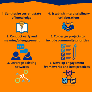
Recently, our scientists and members from fishing communities, Indigenous communities, government, and academia co-published a paper about ensuring fisheries, aquaculture, and Indigenous communities are included in planning and implementing marine carbon dioxide removal projects. They made six recommendations for engaging and collaborating with affected communities and noted that co-developed projects are more likely to address benefits and risks successfully.
|
Engaging Local Fishermen on Bycatch Sea Days
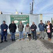
Last month, staff from our Fishery Monitoring and Research Division and their collaborators met with local fishermen in Chincoteague, Virginia, to discuss updates to the 2025 Standardized Bycatch Reporting Methodology (SBRM) sea day schedule. The team focused on the additional 107 sea days dedicated to monitoring bottlenose dolphin interactions in the Mid-Atlantic. The team also took the opportunity to help vessel owners/operators obtain required safety decals and support the fishing community’s culture of safety and compliance. We thank our collaborators A.I.S. Inc., NOAA Office of Law Enforcement, and U.S. Coast Guard for helping us address regional fishery observer coverage gaps with Virginia’s fishing community.
|
13th Biennial Atlantic Salmon Ecosystem Forum a Success
This year marked the 13th Biennial Atlantic Salmon Ecosystem Forum. The forum, held in Bangor, Maine, January 13 and 14, had 165 in-person and 50 remote participants. It was one of the bigger and more complex forums we’ve co-organized. The forum brings students, scientists, managers, conservationists, restoration professionals, members from tribal, state and federal governments, non-governmental organizations, and others together to discuss ways to improve our understanding of ecosystem processes that impact riverine, estuarine, and marine habitats.
|
Blog: Adventures of a Field Scientist in the Gulf of Maine
Field season often means long hours, early mornings, late nights, lots of fish, lots of data collection, constantly watching the weather, and flexibility when weather is foul. But it also means that you can experience some fun and amazing things. Field scientist Maura Flynn’s new blog talks about her work during last year’s fall Gulf of Maine Bottom Longline Survey and includes some of the more exciting moments she experienced, “For me, the thrill of bringing up unusual and interesting catches is one of my favorite things about working at sea. To be able to work out on the ocean is an amazing part of my job.” Want to see more sights and scenes from this survey? Then be sure to check out our new photo gallery!
|
Celebrate Winter with Our Paper Snowflakes

This year’s paper snowflake designs celebrate our two octopuses Ink and Blot, and our very charismatic diamondback terrapin Stumpy. While they’re usually living their best lives at our Woods Hole Science Aquarium, they’re currently vacationing with our friends and partners at the Marine Biological Laboratory while construction and renovations at the aquarium continue. Be sure to check out the 16 other designs from previous years linked in this year’s feature. Happy paper crafting!
|
Director's Message
Our science center produces world-class science that directly informs management decisions in our region and beyond. This month, I’d like to highlight seven examples from our work supporting the protection and recovery of endangered North Atlantic right whales.
1. Right Whale Abundance is Slowly Increasing
In collaboration with a number of partners, our scientists led the annual assessment of North Atlantic right whale abundance. In the 2025 assessment, the team found that right whale abundance is increasing, albeit slowly. The abundance estimate is based on an innovative mark-recapture model, with initial sightings considered “marks” and re-sightings considered “recaptures.” This model was developed by our scientists in 2017. During the 2025 assessment, we were able to improve the model by adding known calf births directly into the estimate of abundance. Mark-recapture modeling typically requires individuals that are identifiable by unique marks. Those involved in right whale research use aerial survey photos of the natural callosity patterns on the whale’s head as the unique identifiable mark. For newly born calves, these callosity patterns can take nearly a year after birth to develop. In the past, this has prevented us and others from including calves in population estimates. Being able to include recent calf births in models improved the precision for yearly population estimates.
2. Genetics Study Supports Model Abundance Estimates
A recently published genetics study supports the abundance estimate derived from the state-of-the-art sighting-resighting model. As I mentioned, the improved sighting-resighting model is based on aerial survey photos taken of right whale callosity patterns. But what if some of the whales are always outside the area covered by aerial surveys? Would the model underestimate the population? We co-authored a paper that used genetics to estimate paternity of calves. Using that data, the team was able to estimate male abundance of the population and compare this to male abundance from the mark-recapture model. The two abundance estimates were very similar, indicating that there is not a group of unobserved whales and that the current abundance estimates are accurate.
3. Updated Analysis Forecasts Lower Probability of Extinction
The Population Viability Analysis estimates right whale extinction risk. The first Population Viability Analysis was completed in 2023. The updated analysis included recent mortality and birth estimates from 2020 to 2022. Since 2020, we’ve seen a decrease in deaths and an increase in births. That means if the recent population growth continues, the forecasted extinction risk is lower. This pattern is similar to what was predicted in the first analysis when the model included a 70% reduction in the severe entanglement rates experienced from 2013-2019. This suggests that management actions taken by Canada in 2020 and the United States in 2021 have reduced mortality risk and therefore reduced deaths and improved the outlook for the species.
4. Tool Helps Reduce Entanglement Risk
Several of our scientists led a team that recently published a peer-reviewed methods paper about the Woods Hole Analysis of Line Entanglement Risk Decision Support Tool. Users can compare different management scenarios like area closures, weak-ropes, and trap reductions in a common currency—the risk of entanglement. The tool was developed to support efforts to reduce entanglement risk through the Atlantic Large Whale Take Reduction Team.
5. Large-Scale Passive Acoustic Monitoring Can Help Reduce Right Whale Vessel Strikes
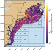
Our scientists have demonstrated that large-scale passive acoustic monitoring of right whales is possible and can inform efforts to reduce vessel strikes. We use two types of acoustic recording sensors for monitoring marine species: archival and near-real time. Archival sensors provide data when the sensor is retrieved from the field, while near-real time sensors transmit data in near-real time via satellites. Our scientists have led a team at NOAA Fisheries to develop a pilot Passive Acoustic Monitoring network. The effort applies passive acoustic technology to help with marine mammal conservation efforts and ocean health. Because of the investment in the network, we’re able to identify areas important to right whales and know when the areas change. Our near-real time acoustic data is used to identify Right Whale Slow Zones—a NOAA Fisheries management tool that notifies vessel operators in slow zone areas to slow down and avoid right whales
6. Using Artificial Intelligence to Detect Whales
Using AI to detect whales from satellite data is one of several high-risk high-reward efforts at NOAA Fisheries. This work improves whale detection capabilities and thus near-real time risk management of right whales and other marine mammals. Our scientists continue to work with a large group of collaborators to develop satellite detection of whales using AI. The Geospatial Artificial Intelligence for Animals (GAIA) initiative is developing a new manual and automated methods to support protected species assessments. The Initiative is combining very high-resolution satellite imagery, machine learning, and cloud computing to detect marine mammals. In June 2025, we launched GAIA version 0.1—the first version of our cloud-based application that is based on the initial Microsoft AI for Good prototype.
7. Monitoring Right Whale Calving Grounds
We continue to work with NOAA’s Southeast Fisheries Science Center, Southeast Regional Office, and other long-term partners and collaborators to monitor the right whale calving grounds off the coast of Florida and Georgia. Together, we conduct real-time boat-based monitoring of right whale mom and calf pairs from January through February. Because the calving range is so large, multiple teams are needed to collect essential data, including biological samples from mothers and calves and drone assessments on whale health and calf growth rates. To date, 21 calves have been documented this season.
We continue to make similar progress in other areas including fisheries and aquaculture in support of our mission—providing the best scientific information and tools necessary for productive, sustainable, and healthy marine ecosystems and coastal communities in our region.
|
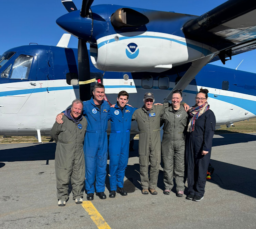 |
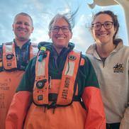
Caption: NOAA Aerial Survey Team, fall 2025 at the Îles de la Madeleine Airport, in Havre-aux-Maisons, Quebec. Our scientists conduct aerial surveys with NOAA Office of Marine and Aircraft Operations using Twin Otter aircraft.
|