|
Please be advised: Maine state officials have requested fishermen with gear in this area to use one endline.
See excerpts from Maine Department of Marine Resources below:
"A large number of endangered North Atlantic right whales remain off the western edge of Jeffreys Ledge. As many as 90 individual right whales have been identified in this area over the past couple of weeks.
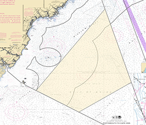
The most recent information suggests the whales may be feeding within Jeffreys Basin and the largest overlap of gear and whales appears to be in depths greater than 300 feet. I am strongly urging any lobster fisherman with trap gear set in greater than 300 feet of water inside the following area of Zone G to remove gear completely or drop one endline in order to reduce the number of vertical lines being fished. The identified area, as shown in the attached graphic, includes bottom in 300+ feet of water east of Boon Island Light and west of Jeffreys Ledge."
 "Boats of any size can injure or kill a whale if a collision occurs. A voluntary slow zone of ten knots remains in effect for this area. Right whales can be difficult to see on the surface so do not assume that if you do not see a right whale, it is not there; there are large surface-active groups in the area. Vessels transiting the area at night should be extremely careful as a collision with a right whale will not only injure the whale but also puts your safety at risk. Do not assume a right whale will avoid your vessel."
For more information, visit Maine Department of Marine Resources website here: https://content.govdelivery.com/accounts/MEDMR/bulletins/3cead10
|