New Right Whale Slow Zone: NE of Atlantic City, NJ
Effective Through January 11, 2025
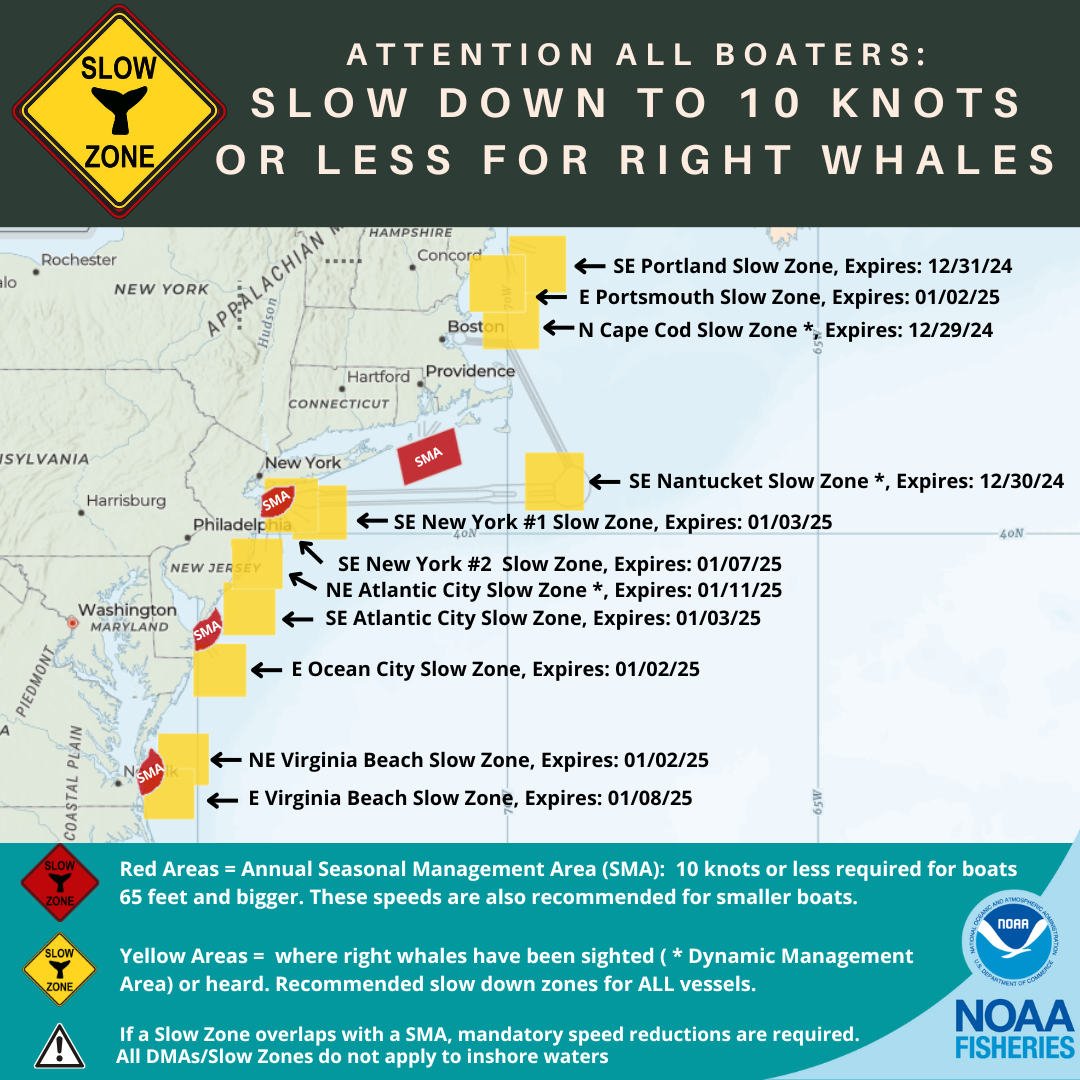
On December 27, 2024, the Azura Mid-Atlantic Right Whale Aerial Survey team detected the presence of right whales northeast of Atlantic City, New Jersey. The right whale Slow Zone is in effect through January 11, 2025.
As a reminder, ten additional Slow Zones are also currently in effect. Locations and effective dates are listed below.
VOLUNTARY Right whale "Slow Zone" AREAS
Mariners are requested to avoid or transit at 10 knots or less inside the following Dynamic Management Areas (DMAs) and Acoustic Slow Zones where right whales have been detected. Please visit our website for more information.
Northeast of Atlantic City, NJ DMA Slow Zone: Effective December 27, 2024 - January 11, 2025
Waters bounded by:
NORTHERN BOUNDARY: 39°56' N
SOUTHERN BOUNDARY: 39°19' N
EASTERN BOUNDARY: 73°38' W
WESTERN BOUNDARY: 74°28' W
East of Virginia Beach, VA Acoustic Slow Zone: Effective December 24, 2024 - January 8, 2025
Waters bounded by:
NORTHERN BOUNDARY: 37°02' N
SOUTHERN BOUNDARY: 36°23' N
EASTERN BOUNDARY: 75°03' W
WESTERN BOUNDARY: 75°53' W
Southeast of New York #2, NY Acoustic Slow Zone: Effective December 23, 2024 - January 7, 2025
Waters bounded by:
NORTHERN BOUNDARY: 40°41' N
SOUTHERN BOUNDARY: 40°01' N
EASTERN BOUNDARY: 73°03' W
WESTERN BOUNDARY: 73°55' W
Southeast of Atlantic City, NJ Acoustic Slow Zone: Effective December 19, 2024-January 3, 2025
Waters bounded by:
NORTHERN BOUNDARY: 39°25' N
SOUTHERN BOUNDARY: 38°44' N
EASTERN BOUNDARY: 73°44' W
WESTERN BOUNDARY: 74°36' W
Southeast of New York #1, NY Acoustic Slow Zone: Effective December 19, 2024-January 3, 2025
Waters bounded by:
NORTHERN BOUNDARY: 40°36' N
SOUTHERN BOUNDARY: 39°56' N
EASTERN BOUNDARY: 72°36' W
WESTERN BOUNDARY: 73°28' W
Northeast of Virginia Beach, VA Acoustic Slow Zone: Effective December 18, 2024-January 2, 2025
Waters bounded by:
NORTHERN BOUNDARY: 37°29' N
SOUTHERN BOUNDARY: 36°50' N
EASTERN BOUNDARY: 74°49' W
WESTERN BOUNDARY: 75°40' W
East of Portsmouth, NH Acoustic Slow Zone: Effective December 18, 2024-January 2, 2025
Waters bounded by:
NORTHERN BOUNDARY: 43°22' N
SOUTHERN BOUNDARY: 42°41' N
EASTERN BOUNDARY: 69°43' W
WESTERN BOUNDARY: 70°38' W
East of Ocean City, MD Acoustic Slow Zone: Effective December 18, 2024-January 2, 2025
Waters bounded by:
NORTHERN BOUNDARY: 38°38' N
SOUTHERN BOUNDARY: 37°58' N
EASTERN BOUNDARY: 74°13' W
WESTERN BOUNDARY: 75°04' W
Southeast of Portland, ME Acoustic Slow Zone: Effective December 16-31, 2024
Waters bounded by:
NORTHERN BOUNDARY: 43°35' N
SOUTHERN BOUNDARY: 42°55' N
EASTERN BOUNDARY: 69°04' W
WESTERN BOUNDARY: 69°59' W
Southeast of Nantucket, MA DMA Slow Zone: Effective December 15-30, 2024
Waters bounded by:
NORTHERN BOUNDARY: 41°00' N
SOUTHERN BOUNDARY: 40°17' N
EASTERN BOUNDARY: 68°47' W
WESTERN BOUNDARY: 69°44' W
North of Cape Cod, MA DMA Slow Zone: Effective December 14-29, 2024
Waters bounded by:
NORTHERN BOUNDARY: 42°56' N
SOUTHERN BOUNDARY: 42°14' N
EASTERN BOUNDARY: 69°30' W
WESTERN BOUNDARY: 70°24' W
|