Two New Right Whale Slow Zones: E and SE of Atlantic City, NJ - Effective Through 2/26

Having trouble viewing this email? View it as a Web page.

NOAA Fisheries - New England - Mid Atlantic Bulletin

February 12, 2024

Two New Right Whale Slow Zones: E and SE of Atlantic City, NJ

Effective Through February 26

On February 11, 2024, the RPS Group Wind Energy PSO detected the presence of right whales east of Atlantic City, NJ and the Atlantic City buoy operated by the Woods Hole Institution of Oceanography detected the presence of right whales southeast of Atlantic City, NJ. The slow zones are in effect through February 26, 2024.

As a reminder, eight additional Slow Zones are also currently in effect. Locations and effective dates are listed below. 

VOLUNTARY Right whale "Slow Zone" AREAS

Mariners are requested to avoid or transit at 10 knots or less inside the following Dynamic Management Areas (DMAs)  and Acoustic Slow Zones where right whales have been detected. Please visit our website for more information.

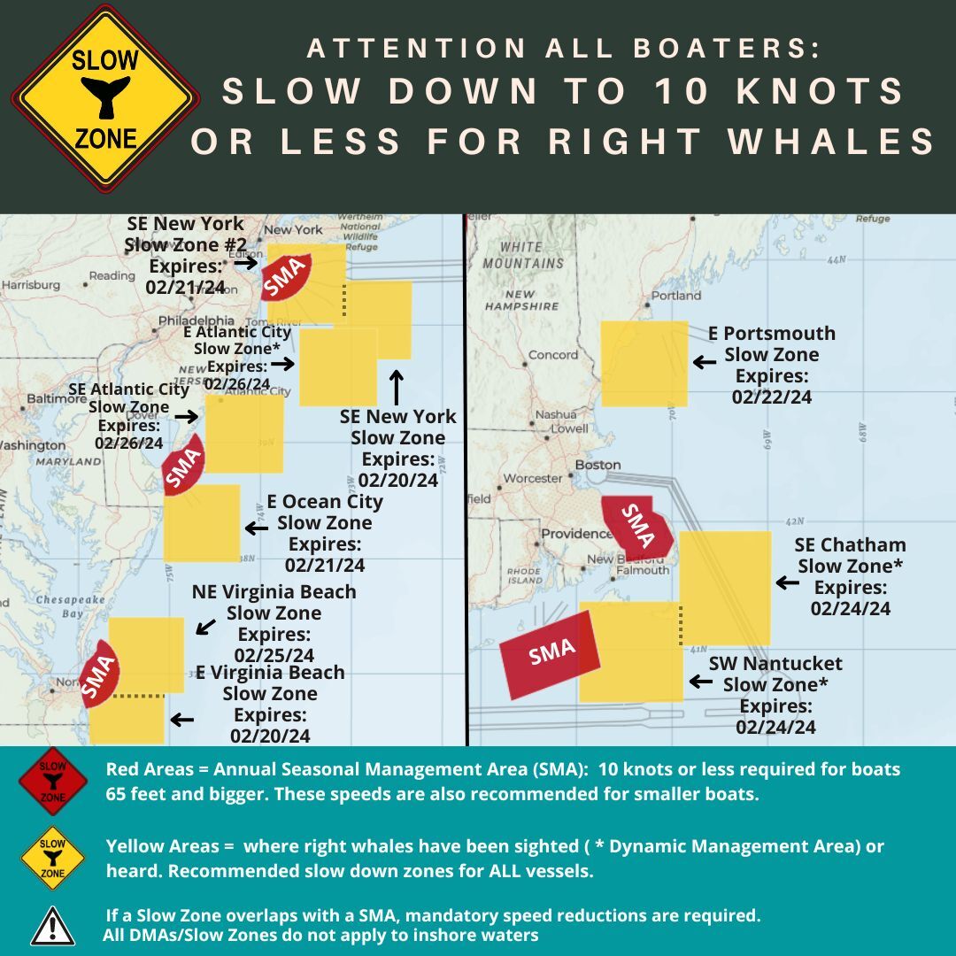
East of Atlantic City, NJ DMA Slow Zone: Effective February 11-26, 2024

Waters bounded by:
NORTHERN BOUNDARY: 39°58' N

SOUTHERN BOUNDARY: 39°19' N

EASTERN BOUNDARY: 72°43' W

WESTERN BOUNDARY: 73°34' W

Southeast of Atlantic City, NJ Acoustic Slow Zone: Effective February 11-26, 2024

Waters bounded by:
NORTHERN BOUNDARY: 39°25' N

SOUTHERN BOUNDARY: 38°44' N

EASTERN BOUNDARY: 73°44' W

WESTERN BOUNDARY: 74°36' W

Northeast of Virginia Beach, VA Acoustic Slow Zone: Effective February 10-25, 2024

Waters bounded by:
NORTHERN BOUNDARY: 37°29' N

SOUTHERN BOUNDARY: 36°50' N

EASTERN BOUNDARY: 74°50' W

WESTERN BOUNDARY: 75°40' W

Southeast of Chatham, MA DMA Slow Zone: Effective February 9-24, 2024

Waters bounded by:
NORTHERN BOUNDARY: 41°56' N

SOUTHERN BOUNDARY: 41°02' N

EASTERN BOUNDARY: 68°58' W

WESTERN BOUNDARY: 69°55' W

Southwest of Nantucket, MA DMA Slow Zone: Effective February 9-24, 2024

Waters bounded by:
NORTHERN BOUNDARY: 41°23' N

SOUTHERN BOUNDARY: 40°35' N

EASTERN BOUNDARY: 69°53' W

WESTERN BOUNDARY: 70°58' W

East of Portsmouth, NH Acoustic Slow Zone: Effective February 7-22, 2024

Waters bounded by:
NORTHERN BOUNDARY: 43°32' N

SOUTHERN BOUNDARY: 42°53' N

EASTERN BOUNDARY: 69°50' W

WESTERN BOUNDARY: 70°45' W

East of Ocean City, MD Acoustic Slow Zone: Effective February 6-21, 2024

Waters bounded by:
NORTHERN BOUNDARY: 38°38' N

SOUTHERN BOUNDARY: 37°58' N

EASTERN BOUNDARY: 74°13' W

WESTERN BOUNDARY: 75°04' W

Southeast of New York, NY Acoustic Slow Zone #2: Effective February 6-21, 2024

Waters bounded by:
NORTHERN BOUNDARY: 40°41' N

SOUTHERN BOUNDARY: 40°01' N

EASTERN BOUNDARY: 73°03' W

WESTERN BOUNDARY: 73°55' W

Southeast of New York, NY Acoustic Slow Zone: Effective February 5-20, 2024

Waters bounded by:
NORTHERN BOUNDARY: 40°22' N

SOUTHERN BOUNDARY: 39°43' N

EASTERN BOUNDARY: 72°20' W

WESTERN BOUNDARY: 73°12' W

East of Virginia Beach, VA Acoustic Slow Zone: Effective February 5-20, 2024

Waters bounded by:
NORTHERN BOUNDARY: 37°03' N

SOUTHERN BOUNDARY: 36°23' N

EASTERN BOUNDARY: 75°04' W

WESTERN BOUNDARY: 75°53' W

Map of current right whale slow zones.

Active Seasonal Management Areas (SMAs)

Mandatory speed restrictions of 10 knots or less (50 CFR 224.105) are in effect for vessels 65 feet or larger in the following areas:

  • Mid-Atlantic U.S. SMAs (Nov. 1-Apr. 30)
  • Southeast U.S. SMAs (Nov. 15-Apr. 15)
  • Cape Cod Bay SMA (Jan. 1-May 15)

Give Right Whales Room

North Atlantic right whales are on the move along the Atlantic coast of the U.S. If seen, remember that approaching a right whale closer than 500 yards is a violation of federal and state law.

Right Whales in Trouble

Endangered North Atlantic right whales are approaching extinction. There are approximately 360 individuals remaining, including fewer than 70 reproductively active females. Human impacts continue to threaten the survival of this species.

In August 2017, NOAA Fisheries declared the increase in right whale mortalities an “Unusual Mortality Event,” which helps the agency direct additional scientific and financial resources to investigating, understanding, and reducing the mortalities in partnership with the Marine Mammal Stranding Network, Canada’s Department of Fisheries and Oceans, and outside experts from the scientific research community.

More Information

Details and graphics of all of all vessel strike management zones currently in effect.

Download the Whale Alert app for iPad, iPhone, and Android for real time updates on Slow Zones, SMAs, and other right whale sightings.

Recent right whale sightings and real-time acoustic detections along the eastern seaboard. 

Find out more about our right whale conservation efforts and the researchers behind those efforts.

Spread the Word!

All boaters from Maine to Virginia, or interested parties, can sign up for email or text notifications about the latest Right Whale Slow Zones. You can also follow us on Facebook (@NOAAFisheriesNEMA) and Twitter (@NOAAFish_GARFO) for announcements.

Share our video on Right Whale Slow Zones.

Questions?

Media: Contact GARFO Public Affairs