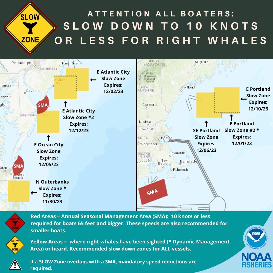
Effective Through December 12
NOAA Fisheries announces a voluntary Right Whale Slow Zone (acoustic trigger). On November 27, 2023, the Coastal New Jersey Slocum glider operated by Rutgers University and Woods Hole Oceanographic Institution detected the presence of right whales east of Atlantic City, NJ. The right whale Slow Zone is in effect through December 12, 2023.
As a reminder, six additional Slow Zones are also currently in effect. Locations and effective dates are listed below.
VOLUNTARY Right whale "Slow Zone" Areas
Mariners are requested to avoid or transit at 10 knots or less inside the following Dynamic Management Areas (DMAs) and Acoustic Slow Zones where right whales have been detected. Please visit our website for more information.
East of Atlantic City, NJ #2 Acoustic Slow Zone: Effective November 27-December 12, 2023
Waters bounded by:
NORTHERN BOUNDARY: 39°38' N
SOUTHERN BOUNDARY: 38°58' N
EASTERN BOUNDARY: 73°33' W
WESTERN BOUNDARY: 74°25' W
East of Portland, ME Acoustic Slow Zone: Effective November 25-December 10, 2023
Waters bounded by:
NORTHERN BOUNDARY: 43°44' N
SOUTHERN BOUNDARY: 43°05' N
EASTERN BOUNDARY: 68°10' W
WESTERN BOUNDARY: 69°05' W
Southeast of Portland, ME Acoustic Slow Zone: Effective November 21-December 6, 2023
Waters bounded by:
NORTHERN BOUNDARY: 43°36' N
SOUTHERN BOUNDARY: 42°56' N
EASTERN BOUNDARY: 68°48' W
WESTERN BOUNDARY: 69°43' W
East of Ocean City, MD Acoustic Slow Zone: Effective November 20-December 5, 2023
Waters bounded by:
NORTHERN BOUNDARY: 38°38' N
SOUTHERN BOUNDARY: 37°58' N
EASTERN BOUNDARY: 74°13' W
WESTERN BOUNDARY: 75°04' W
East of Atlantic City, NJ Acoustic Slow Zone: Effective November 17-December 2, 2023
Waters bounded by:
NORTHERN BOUNDARY: 39°52' N
SOUTHERN BOUNDARY: 39°12' N
EASTERN BOUNDARY: 73°07' W
WESTERN BOUNDARY: 73°59' W
East of Portland, ME #2 DMA Slow Zone: Effective November 16-December 1, 2023
Waters bounded by:
NORTHERN BOUNDARY: 43°40' N
SOUTHERN BOUNDARY: 43°02' N
EASTERN BOUNDARY: 68°10' W
WESTERN BOUNDARY: 69°02' W
Northern Outerbanks DMA Slow Zone: Effective November 15-30, 2023
Waters bounded by:
NORTHERN BOUNDARY: 36°33' N
SOUTHERN BOUNDARY: 35°53' N
EASTERN BOUNDARY: 75°20' W
WESTERN BOUNDARY: 76°10' W
The Northern Outerbanks DMA does not apply to any inshore waters.
|