August 28, 2023 to October 18, 2023
NOAA Fisheries Deep Sea Coral Research and Technology Program and Saildrone Inc. are using the USVs for research purposes to collect high-resolution seafloor bathymetry and backscatter data along predetermined survey tracklines. This project surveys deep sea corals and canyons.
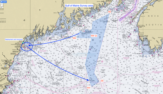
SAILDRONE, INC. will be conducting research to collect high resolution seafloor bathymetry and backscatter data with up to two Uncrewed Surface Vehicles (USVs), called SAILDRONE VOYAGERs, in the eastern third of the Gulf of Maine. These vehicles will conduct 24 hr operations from August 28 through October 18.
Fishing Vessels Asked to Avoid Area if Possible
Fishing vessel operators who use fixed gears should avoid setting gear in areas planned for survey to help limit any risk of entanglement between the SAILDRONE VOYAGERS’ sound velocity profile casts and vertical lines.
SAILDRONE VOYAGERs are equipped with radar, Automatic Identification Systems (AIS), and cameras. They operate at speeds between 2-4 knots, moving between a series of predetermined waypoints. Vehicles are monitored remotely 24/7 by the Saildrone Mission Control Team.
Area of Operation
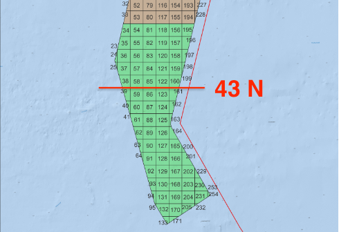
Phase 1 of the survey operations will be focused on the in the southern portion of the survey area, with the first two weeks of operations scheduled to be conducted south of 43° N. As the survey progresses, updates on Voyager locations will be shared bi-weekly.
|
NE
|
44°23’58.6”N
|
67°12’09.2”N
|
|
NW
|
43°47’26.3”N
|
68°18’56.1”N
|
|
NW (2)
|
43°47’03.2”N
|
67°49’22.9”N
|
|
SW
|
42°32’05.7”N
|
67°48’43.2”N
|
|
SE
|
42°38’01.8”N
|
67°36’17.5”N
|
 Phase 1 focus area below.
|