|
On March 17, 2022, the Ocean City buoy operated by the University of Maryland Center for Environmental Science/Woods Hole Oceanographic Institution detected the presence of right whales East of Ocean City, MD. The right whale SLOW Zone is in effect immediately and expires on April 1, 2022.
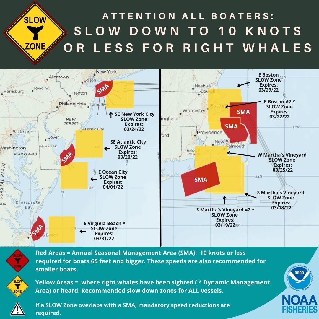
VOLUNTARY Right whale "Slow Zone" AREAS
As a reminder, eight additional SLOW Zones are also currently in effect.
Mariners are requested to avoid or transit at 10 knots or less inside the following areas where persistent aggregations of right whales have been detected. Please visit www.nmfs.noaa.gov/pr/shipstrike for more information.
- East of Virginia Beach, VA, expires on March 31, 2022.
- East of Boston, MA, expires on March 29, 2022.
- West of Martha's Vineyard, MA, expires on March 25, 2022.
- Southeast of New York City, NY, expires on March 24, 2022.
- East of Boston #2, MA, expires on March 22, 2022.
- Southeast of Atlantic City, NJ, expires on March 20, 2022.
- South of Martha's Vineyard #2, MA, expires on March 19, 2022.
- South of Martha's Vineyard, MA, expires on March 18, 2022.
East of Ocean City, MD SLOW Zone: Effective March 17-April 1, 2022
Waters bounded by:
NORTHERN BOUNDARY: 38°38' N
SOUTHERN BOUNDARY: 37°58' N
EASTERN BOUNDARY: 74°13' W
WESTERN BOUNDARY: 75°04' W
East of Virginia Beach, VA DMA SLOW Zone: Effective March 16-31, 2022
Waters bounded by:
NORTHERN BOUNDARY: 37°18' N
SOUTHERN BOUNDARY: 36°38' N
EASTERN BOUNDARY: 74°37' W
WESTERN BOUNDARY: 75°26' W
East of Boston, MA Acoustic SLOW Zone: Effective March 14-29, 2022
Waters bounded by:
NORTHERN BOUNDARY: 42°46' N
SOUTHERN BOUNDARY: 42°06' N
EASTERN BOUNDARY: 70°11' W
WESTERN BOUNDARY: 71°05' W
West of Martha's Vineyard, MA Acoustic SLOW Zone: Effective March 10-25, 2022
Waters bounded by:
NORTHERN BOUNDARY: 41°38' N
SOUTHERN BOUNDARY: 40°58' N
EASTERN BOUNDARY: 70°32' W
WESTERN BOUNDARY: 71°26' W
Southeast of New York City, NY Acoustic SLOW Zone: Effective March 9-24, 2022
Waters bounded by:
NORTHERN BOUNDARY: 40°35' N
SOUTHERN BOUNDARY: 39°56' N
EASTERN BOUNDARY: 72°47' W
WESTERN BOUNDARY: 73°40' W
East of Boston #2, MA DMA SLOW Zone: Effective March 7-22, 2022
Waters bounded by:
NORTHERN BOUNDARY: 42°37' N
SOUTHERN BOUNDARY: 41°58' N
EASTERN BOUNDARY: 70°08' W
WESTERN BOUNDARY: 71°02' W
Southeast of Atlantic City, NJ Acoustic SLOW Zone: Effective March 5-20, 2022
Waters bounded by:
NORTHERN BOUNDARY: 42°46' N
SOUTHERN BOUNDARY: 42°06' N
EASTERN BOUNDARY: 70°11' W
WESTERN BOUNDARY: 71°05' W
South of Martha's Vineyard #2, MA DMA SLOW Zone: Effective March 4-19, 2022
Waters bounded by:
NORTHERN BOUNDARY: 41°25' N
SOUTHERN BOUNDARY: 40°41' N
EASTERN BOUNDARY: 70°10' W
WESTERN BOUNDARY: 71°10' W
South of Martha's Vineyard, MA Acoustic SLOW Zone: Effective March 3-18, 2022
Waters bounded by:
NORTHERN BOUNDARY: 41°19' N
SOUTHERN BOUNDARY: 40°39' N
EASTERN BOUNDARY: 70°05' W
WESTERN BOUNDARY: 70°58' W
 Active Seasonal Management Areas (SMAs)
Mandatory speed restrictions of 10 knots or less (50 CFR 224.105) are in effect in the following areas:
Off Race Point SMA
Cape Cod Bay SMA
Mid-Atlantic U.S. SMAs
Southeast U.S. SMAs
Give Right Whales Room
North Atlantic right whales are on the move along the Atlantic coast of the U.S. If seen, remember that approaching a right whale closer than 500 yards is a violation of federal and state law.
Right Whales in Trouble
North Atlantic right whales are protected under the U.S. Endangered Species Act and the Marine Mammal Protection Act. Scientists estimate there are fewer than 350 individuals remaining, making them one of the rarest marine mammals in the world.
In August 2017, NOAA Fisheries declared the increase in right whale mortalities an “Unusual Mortality Event,” which helps the agency direct additional scientific and financial resources to investigating, understanding, and reducing the mortalities in partnership with the Marine Mammal Stranding Network, Canada’s Department of Fisheries and Oceans, and outside experts from the scientific research community.
More Information
Details and graphics of all of all vessel strike management zones currently in effect.
Download the Whale Alert app for iPad and iPhone for real time updates on Slow Zones, SMAs, and other right whale sightings.
Recent right whale sightings and real-time acoustic detections along the eastern seaboard.
Find out more about our right whale conservation efforts and the researchers behind those efforts.
Spread the Word!
All boaters from Maine to Virginia, or interested parties, can sign up for email or text notifications about the latest Right Whale Slow Zones. You can also follow us on Facebook (@NOAAFisheriesNEMA) and Twitter (@NOAAFish_GARFO) for announcements.
Share our video on Right Whale Slow Zones.
Questions?
Media: Contact Allison Ferreira, Regional Office, (978) 281-9103
|