Update from Massachusetts Division of Marine Fisheries
The Division of Marine Fisheries (DMF) is closely monitoring the presence of North Atlantic Right Whales in Massachusetts coastal waters. From the period of April 6, 2021 through April 20, 2021 aerial and acoustic surveillance conducted by the NOAA Fisheries and the Provincetown Center for Coastal Studies (PCCS) has detected moderate to high densities of right whales in Massachusetts coastal waters including; Cape Cod Bay, Massachusetts Bay, Stellwagen Bank, state waters on the backside of Cape Cod, and the nearshore federal waters south of Martha’s Vineyard and Nantucket.
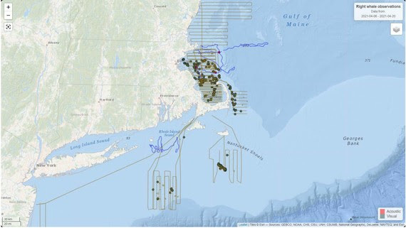 Aerial and acoustic detections of North Atlantic Right Whales from April 6, 2021 through April 20, 2021. (Tan lines are aerial surveillance tracks and blue lines represent acoustic surveillance tracks of the Slocum glider).
Trap fishermen in Lobster Management Area 1 and Outer Cape Cod are reminded that the state waters portion of these areas are closed to lobster trap fishing until May 15, 2021. NOAA Fisheries and PCCS are conducting routine aerial surveillance throughout Massachusetts' coastal waters and adjacent federal waters multiple times per week. DMF will continue to monitor surveillance information and could open portions or all of state waters as early as May 1, 2021 if less than 3 right whales are detected in an area.
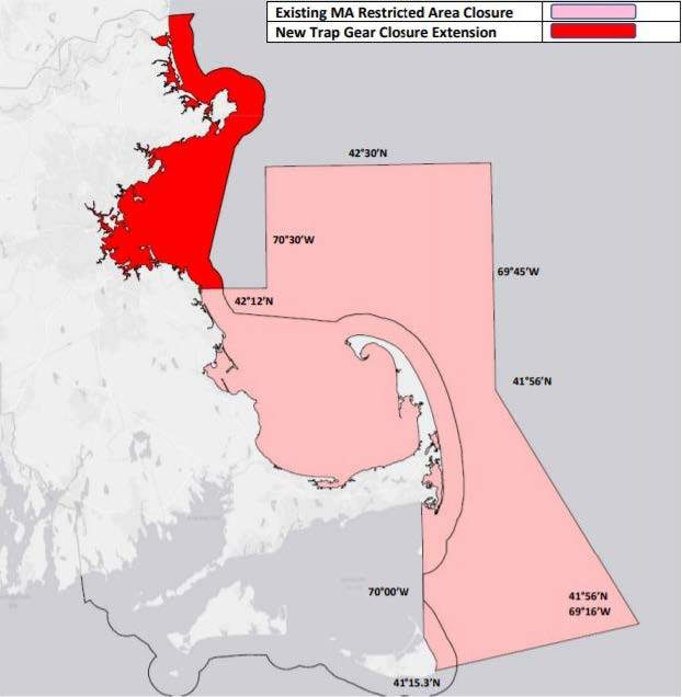 MA Seasonal trap gear closure February 1 through May 15th. Pink area in effect since 2015. Red area in effect since March 2021
Mariners are reminded that there is a 10-knot small vessel (less than 65’ overall) speed limit in Cape Cod Bay to protect endangered right whales from the threat of ship strikes that remains in effect until April 30, 2021. During the late winter and early-spring, right whales migrate into and aggregate in Cape Cod Bay where they feed on zooplankton. As we move into the spring, these whales begin to feed closer to the surface and become more susceptible to ship strikes. Ship strikes are a significant source of mortality to these endangered whales. However, the lethality of ship strikes is greatly reduced when vessels are operating at less than 10-knots speed.
This small vessel speed limit— established in 2019—applies from March 1 – April 30 within those waters of Cape Cod Bay south of 42° 08’ north latitude, as well as those waters north of Cape Cod that are west of 70°10’ west longitude. A complementary federal speed limit applies to all vessels 65’ overall length and greater. DMF may extend or rescind this seasonal small vessel speed limit based on the continued presence or absence of whales. This small vessel speed limit does not apply to emergency and enforcement personnel, including federal whale disentanglement teams. Additionally, small vessel traffic operating within the inshore waters of Plymouth, Duxbury, Kingston, Barnstable and Wellfleet Harbors are exempt.
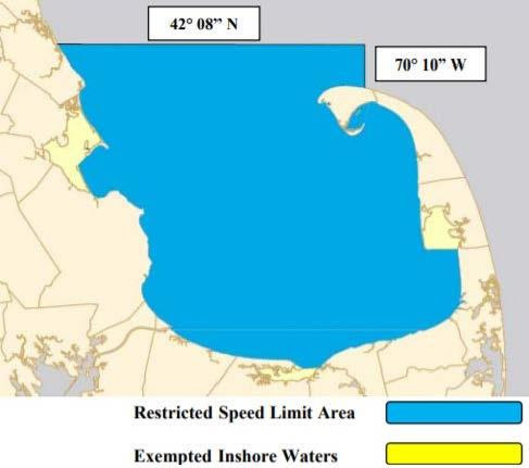 Massachusetts right whales small vessel speed restricted area – March 1 to April 30
|