|
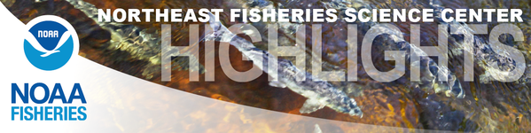
Exploring the Ocean Twilight Zone
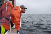
Deep-See is a one-of-a-kind acoustic, optic, oceanographic, and biological sampling system created to explore a layer of the ocean just off the edge of the continental shelf known as the Ocean Twilight Zone. This is where light from the surface stops penetrating—about 660 to 3,300 feet deep—and where the largest animal migration on Earth happens each and every day. Bringing our expertise together with that of our research partner, Woods Hole Oceanographic Institution, we are at sea on our first science cruise to better understand the organisms living in this little known ocean layer. This one of a kind collaborative research is possible thanks to the capabilities of the NOAA Ship Henry B. Bigelow, which is equipped with a 4,000-meter (about 13,000 feet long) fiber optic cable, and has other scientific and gear handling capabilities needed for this project.
|
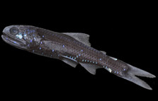
GoFISH Connects Science with Fishing Industry
GoFISH is a computer app being developed by our Cooperative Research Branch for commercial fishing captains and vessel owners to help them analyze and visualize their fishing data. Jeffrey Pessutti at the Center’s Sandy Hook lab designed the app, directly collaborating with the fishing industry to maximize benefits to the app’s users. GoFISH is intended to help commercial fishing businesses operate more efficiently, avoid negative impacts on the ecosystem such as by-catch, and contribute to accurate and complete reporting of fishing data. GoFISH also allows scientists and fishermen to work together to share important information about fish habitats and the state of the fisheries.
|
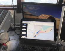
Let’s Celebrate Shark Week!
This week we’re highlighting all things shark, like our Cooperative Shark Tagging Program. In 1962, our Science Center began its Tagging Program with about 100 volunteer recreational and commercial fishermen, scientists, and fisheries observers. Today they have more than 7,000 volunteers contributing data to the Tagging Program. Data from tagging and recapture events have been instrumental in shaping what we know about shark migration and distribution. It also helped to define the essential fish habitat for 38 federally managed shark species and continues to be used in defining and updating areas designated as essential for shark survival.
|
Partnership in Search of Oyster Probiotics
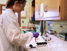
Scientists at our Milford lab completed a test of a freeze-dried probiotic strain (OY15) on larval oysters. OY15 was manufactured and provided through a partnership with Prospective Research, a Massachusetts company that creates microbial, feed-incorporated preventative disease management solutions for the aquaculture industry. After completing microscopic counts on more than 200 preserved larval samples, researchers will determine if this probiotic can prevent disease in larval oysters and therefore improve their survival. This is a great example of how our fisheries scientists are working with industry to promote aquaculture production in the United States.
|
Stock Assessments Under Review
From August 5-7, the results of stock assessments for black sea bass, bluefish, monkfish and scup will be reviewed by an independent panel of experts. These assessments incorporate updated survey and commercial fishery data and newly revised estimates of recreational catch. From September 9-12, the results of Northeast groundfish assessments will be reviewed—stay tuned for more to come!
|
Cape Cod Seals and Sharks: Top Ten Facts
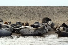
Seals and white sharks have inhabited Cape Cod waters for centuries, long before humans arrived. After decades without seeing many, residents and visitors now find gray and harbor seals and sharks in increasing numbers since federal regulations protecting the animals were put into place. While these animals have some things in common, some of our top ten seal and shark facts may surprise you.
|
Online Tool Tracks Marine Life
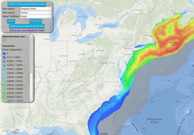
The Marine Mammal Habitat Model Viewer is a new interactive online tool that maps marine life sightings and ocean conditions to help inform marine resource management decisions. The maps use whale, dolphin, and porpoise sightings data collected during our shipboard and aerial surveys, environmental habitat data like temperature and salinity, and information about physical characteristics like seafloor shape and distance from shore. The resulting information provides a way to predict marine animal densities. Prediction data can be viewed online as a map or downloaded for other data analysis. The Center’s Atlantic Marine Assessment Program for Protected Species (AMAPPS) team created this tool and they plan to expand it to include sea turtles and seals.
|
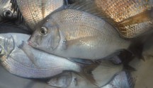
Sharks, Rays, Skates, and More
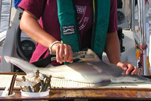
The Shark Week science fun continues! Right now scientists from our Science Center are out on another leg of the annual Cooperative Atlantic States Shark Pupping and Nursery (COASTSPAN) survey in Delaware Bay. This survey, conducted for about ten days each month in June, July and August, is a collaborative effort to study and monitor shark nursery habitats and better understand what species are using what habitats and why. During the second leg of the survey, they caught nearly 200 species of rays, skates, and sharks. This includes bullnose rays, bluntnose rays, spiny butterfly rays, cownose rays, roughtail rays, clearnose skates, sandbar sharks, sand tigers, smooth dogfish, Atlantic sharpnose sharks, and a finetooth shark—a first ever for this survey!
|
Woods Hole Science Stroll
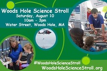
Join us for the Woods Hole Science Stroll Saturday, August 10, from 10 a.m. to 3 p.m. What’s the Science Stroll? It’s an Open House of sorts where our Science Center and other Woods Hole marine and environmental science and education institutions and organizations come together to share their research with the public through interactive demonstrations, exhibits, arts and crafts, fun hands-on activities, and more! So mark your calendars and come get your science on at the Science Stroll—It’s fun, free and family friendly! Parking is limited so be sure to plan accordingly.
|
Spring EcoMon Cruise Completed
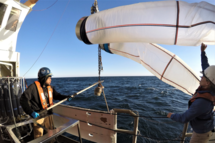
Thanks to a combination of favorable weather and a well-run vessel, the 2019 Northeast spring ecosystem monitoring survey aboard the NOAA Ship Henry B. Bigelow sampled at 139 stations, achieving nearly complete coverage of the Gulf of Maine, Georges Bank, and Southern New England waters. Our EcoMon cruise focuses on plankton—tiny animals and plants at very young stages of some larger ones that provide critical information about the food chain supporting fisheries and marine life in our oceans.
|
Fisheries in a Changing Ocean
Our scientists have been busy searching for answers to the many challenges our fisheries face due to climate change. In the Northeast region, we are experiencing some of the fastest warming ocean conditions—causing changes to many of our fisheries stocks. In 2016, we released a fisheries climate action plan for the region, which was funded by Congress last year. Here is a glimpse at the progress on some of our ongoing research projects on Northeast groundfish and climate.
|
Meet Giovanni Gianesin, Cooperative Research
July’s Face of the Northeast Fisheries Science Center is Giovanni Gianesin, field scientist with our Cooperative Research Branch. Born in Colorado Springs, Colorado, Giovanni’s awe and appreciation for nature and the ocean imprinted at an early age. Much of his youth was spent traveling in the United States with his parents, hiking and camping at National Parks along the way. So it’s no surprise he pursued a career connected to the marine environment. Over his career, he’s been a middle school and high school environmental educator, a fisheries observer in Alaska and along the East Coast, and a fisheries observer trainer. Today Giovanni is a field technician, working on various cooperative research projects and research studies helping connect scientists and commercial fishermen.
|
North Atlantic Right Whale Disentanglement
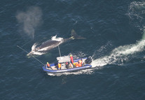
Our North Atlantic Right Whale aerial survey team was working in Canada during the middle of July, searching for North Atlantic right whales as part of their work to document how, and which, whales are using habitat in the Gulf of St. Lawrence. During that time, the survey team spotted a right whale entangled in fishing gear. They provided air support to Canadian rescuers, helping them locate the whale and relaying information about the entanglement to the rescue team during their attempt to remove gear. The team subsequently provided sighting support for three more right whale disentanglement efforts before leaving for home. They are now surveying in the Southern Gulf of Maine and off Cape Cod, and plan to resume work in the Gulf of St. Lawrence in mid-August.
|
Rarely Seen Bird Caught on Camera

A seabird/marine mammal observer sailing on a recent National Science Foundation cruise caught on camera an unusual bird sighting located off the coast of Massachusetts. At first it was thought to be a Peregrine Falcon, but bird experts confirmed the image was of an Eurasian Hobby, a bird rarely seen in the lower 48 states. The sighting (with photographs) was submitted to the Massachusetts Avian Records Committee, which evaluates, archives, and shares records of rare birds. Visual distribution and abundance surveys of sea birds, marine mammals, and sea turtles are conducted as part of the Atlantic Marine Assessment Program for Protected Species (AMAPPS), a partnership between NOAA, the U.S. Fish and Wildlife Service, the Bureau of Ocean Energy Management, and the U.S. Navy.
|
|
|
Upcoming Events
August 5-7 Mid-Atlantic Stock Assessments Peer Review
August 10 Join us for a free family day of marine and environmental science exhibits, demonstrations and hands-on activities at the Woods Whole Science Stroll
August 13 Cooperative Research Engagement Session, 3-5 PM, Portland, ME
August 14 Cooperative Research Engagement Session, 3-5 PM, Gloucester, MA
August 20 Cooperative Research Engagement Session, 3-5 PM, New Bedford, MA
August 27 Cooperative Research Engagement Session, 3-5 PM, Riverhead, NY
August 28 Cooperative Research Engagement Session, 3-5 PM, Point Judith, RI
|
|
|
|
|