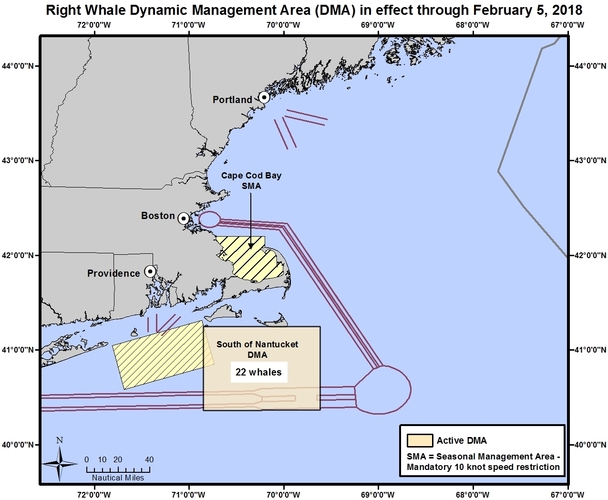
New Voluntary Right Whale Speed Restriction Zone
South of Nantucket
In effect through February 5
NOAA Fisheries announces that a voluntary vessel speed restriction zone (Dynamic Management Area or DMA) has been established 30 nautical miles south of Nantucket, MA to protect an aggregation of 22 right whales sighted in this area on January 23, 2018. This DMA is in effect immediately.
Mariners are requested to route around this area or transit through it at 10 knots or less.
South of Nantucket, MA DMA January 23-February 5
41 15 N
40 22 N
070 51 W
069 37 W
ACTIVE SEASONAL MANAGEMENT AREAS (SMAs)
Mandatory speed restrictions of 10 knots or less are in effect in the following areas:
Cape Cod Bay -- in effect through May 15, 2018
Block Island -- in effect through April 30, 2018
New York, Philadelphia and Norfolk -- through April 30, 2018
Questions? Contact Jennifer Goebel, Regional Office, at 978-281-9175
More Info:
Recent right whale sightings
Download the Whale Alert app for iPad and iPhone
Acoustic detections in Cape Cod Bay and the Boston TSS
Send a blank message to receive a return email listing all current U.S. DMAs adn SMAs.
Details and graphics of all ship strike management zones currently in effect.
Reminder: Approaching a right whale closer than 500 yards in a violation of federal and state law.
Please report all right whale sightings to 866-755-NOAA (6622).
|