In the News:
Annual NLCD Debuts!
October 24, 2024 – Annual NLCD has arrived with a new ability to look at land cover and land change year by year, and over a longer time span than previous versions: from 1985 to 2023.
Two years of effort went into the reinvention of a resource that’s widely used by federal agencies, state and local governments, researchers, and many others. NLCD has contributed to a foundation of data essential for land monitoring, planning, and decision-making.
Previously, NLCD offered land cover information every two to three years from 2001 to 2021. Annual NLCD has a six-product suite that offers land cover and change information for every year for nearly four decades and has a shorter production time going forward. Landsat satellites continue to provide the foundational data for Annual NLCD.
The new October release, called Annual NLCD Collection 1.0, includes information from the previous year for the lower 48 United States, just as the update in 2025 will include information from 2024.
In addition, data access has expanded to the cloud and the USGS data access website EarthExplorer.
Read the USGS news release.
Read about two years of effort at EROS to create Annual NLCD.

Explore:
New Annual NLCD Website
September 26, 2024 – Find all you need to know about Annual NLCD, which harnesses the lengthy Landsat record, at its new website, usgs.gov/annualnlcd. Information there includes:
-
An explanation of the six science products
-
Links to the array of data access options
-
A description of reference and validation efforts
-
The Science Product User Guide

Get the Data
Easy access to Annual NLCD data has expanded to the commercial cloud and EarthExplorer.
Explore data access options.
Read:
New Fact Sheet on Annual NLCD

January 17, 2025 – The widely used National Land Cover Database (NLCD) based on
Landsat imagery has long been the foundational land cover source for scientists, resource managers, and decision makers across the United States. This new four-page fact sheet helps explain the improvements and products provided by Annual NLCD, along with the foundational inputs and the reference and validation efforts. A chart points out some key differences between Annual NLCD and the most recent legacy NLCD release.
View the Annual NLCD fact sheet.
Listen:
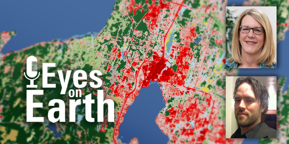
Podcast Offers Overview of Annual NLCD
October 28, 2024 — A new episode of Eyes on Earth, a podcast produced by the USGS Earth Resources Observation and Science (EROS) Center, featured USGS scientists Jesslyn Brown and Jon Dewitz (below) talking about Annual NLCD. In the episode, they give an overview of mapping land cover, the strengths of Annual NLCD, what Annual NLCD offers for data users, the significance of the Landsat satellite program's historical record for this mapping, the importance of assessing Annual NLCD's accuracy, and examples of the variety of uses for Annual NLCD.
Listen to the Annual NLCD episode of Eyes on Earth.
Episode Discusses Accuracy
January 6, 2025 — Another episode about Annual NLCD, featuring land remote sensing scientist Josephine Horton, described the Annual NLCD Research and Validation team's efforts to find stories behind some of the pixels.
Listen to the Eyes on Earth episode about Annual NLCD accuracy.
Watch:
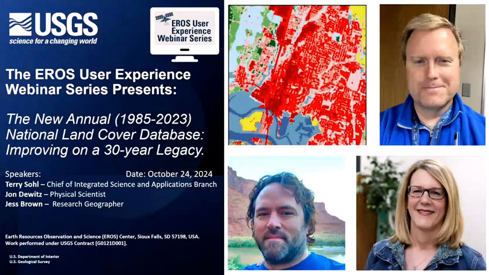
Webinar Showcases Annual NLCD
October 24, 2024 — An EROS User Experience webinar held the same day as the Annual NLCD release featured Terry Sohl, Chief of the Integrated Science and Applications Branch at EROS, along with Jesslyn Brown and Jon Dewitz.
The webinar "The New Annual (1985-2023) National Land Cover Database: Improving on a 30-year Legacy" discussed the new improvements, future plans, the history of NLCD, and the significant impact NLCD has had for science applications, land managers, and decision-makers.
View the Annual NLCD webinar recording.
View:
Annual NLCD Land Change: Northern Dallas
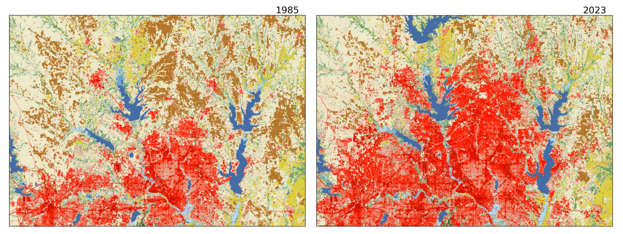
Landsat, which like Annual NLCD benefits from support of the USGS National Land Imaging Program, has been useful for capturing how the land changes in a variety of ways over time, some gradually and some suddenly. The above land change example from Annual NLCD shows the change in the northern Dallas-Fort Worth, Texas, metropolitan area between 1985 and 2023. The progression of urban growth is depicted in shades of red, and Ray Roberts Lake (blue V-shaped object at the top of the right image) emerged after the 1987 completion of the Ray Roberts Dam.
View an animation of this area displaying each year from 1985 to 2023.
Looking back:
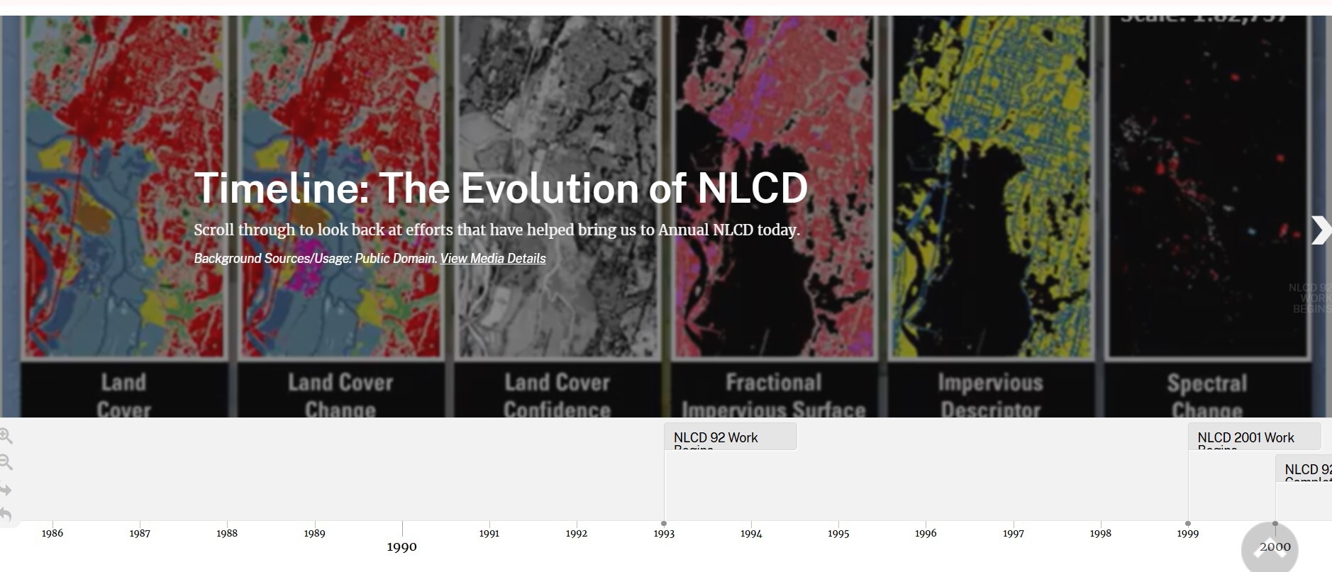
The History of NLCD
October 8, 2024 — While some methods for creating Annual NLCD are new, the database's foundational roots stretch back decades to the first NLCD mapping efforts using Landsat. A new visually focused article traces the evolution of NLCD land cover mapping from those early days through increasingly automated releases over time. Scroll through a timeline of key NLCD developments, too.
Explore "NLCD's Path from Early Landscape Snapshot to Decades of Change."
At AGU:
USGS Land Cover Goes to AGU 2024
The American Geophysical Union (AGU) focused on “What's Next for Science” in its annual meeting in December 2024 in Washington, D.C. AGU provides a forum for Earth and Space science collaboration, discussion, and display, and USGS Land Cover was well represented with posters and talks. Here's a roundup of topics.
Posters:
Aligning NLCD Historical Land Cover Maps Based on Landsat Collection 1 to Collection 2, Congcong Li, Advances in Understanding Land System Change session
Analyses of Interannual Climate Variability and Patterns of Land Cover Change in the Mississippi River Basin, Francis Dwomoh, Advances in Understanding Land System Change session
Creation of a Land Cover and Land Change Reference Dataset for Validation of Annual NLCD Collection 1, Josephine Horton, Advances in Understanding Land System Change session
Future Directions and Updating Capabilities for Annual NLCD, Heather Tollerud, Advances in Understanding Land System Change session
A New Method for Producing Annual Cloud-Free Composite Images of 1984-2023 from Landsat Collection 2 for NLCD 2023 Production, Suming Jin, Emerging Science Applications of Landsat Data session
Performances of Remotely Sensed Surface Temperature in Measuring Surface Temperature in Urban Areas, George Xian, Emerging Science Applications of Landsat Data session
Talks:
Development and Cloud Implementation of the New Annual National Land Cover Database for the United States, Jesslyn Brown, oral presentation, Advances in Understanding Land System Change session
Multi-scale Scenario-based Modeling of Feedbacks among Land Use, Water Use, and Water Availability, Terry Sohl, oral presentation, Multisector Dynamics: Advances in Global-to-Regional Land Use and Land Cover Change Modeling session
Spatiotemporal Deep Learning for Land Cover Mapping with Landsat: Annual NLCD, Rylie Fleckenstein, oral presentation, Advances in Understanding Land System Change session
Find more details at the AGU 2024 website.
On social media:
Social Corner

December 12, 2024 — Social media accounts for USGS EROS have kept people up to date on the release of Annual NLCD and other land cover topics. Here's just one example.
An assessment using Annual NLCD discussed land cover change related
to phosphate mining, especially in the Bone Valley region of Florida. A visually oriented article published on the website, and posts appeared on the EROS social media accounts with a year-by-year animation of land change. The EROS Facebook example shown here received 35 likes and more than 3,000 plays.
View the Facebook post.
Scroll through the visual story.
Social media updates about USGS Land Cover have moved to the USGS EROS social media accounts. Be sure to follow EROS on X (formerly Twitter), Facebook, and Instagram for information on upcoming data, tools, services, and publications.
Know someone who might be interested in USGS land cover products? Forward this email and let them know they can subscribe through this link.
Thanks for being a subscriber!
|