BLM California News.Bytes Issue 1033

View as a webpage


news bytes - bureau of land management california

Desert landscape with hills

South Nopah Wilderness, Barstow Field Office

ISSUE 1033 - January 27, 2023


Welcoming Public Input

OHV rider in the desert

Seeking public input on 2023 OHV grants

Several public and stakeholder meetings will be hosted by the Bureau of Land Management to gather input on the development of off-highway vehicle grant proposals for submission to the California State Parks Off-Highway Motor Vehicle Recreation Division. (BLM News Release)

OHV Rider

BLM and Inyo National Forest seek public input for OHV grants 

Share your ideas on how to ensure off-highway vehicle trails are safe and well maintained on public lands throughout the Eastern Sierra at a virtual public meeting on Tuesday, Feb. 7 at 5 p.m. The public must register to participate in the virtual public meeting. (BLM News Release)

Desert landscape

BLM welcomes comments on mineral exploration proposal

The Bureau of Land Management is seeking public comments on a proposed expansion of gold exploration at the site of the former Hog Ranch Mine, about 60 miles south of Cedarville in Washoe County, Nevada. The project would cover approximately 200 acres of BLM-managed public land.  (BLM News Release)


Headlines and Highlights

BLM and Star Wars characters in the desert

Star Wars - Discover the Desert Day at the Imperial Sand Dunes

The public is invited to a Star Wars - Discover the Desert Day at the Imperial Sand Dunes Recreation Area on Saturday, Feb. 4. The free family-friendly educational event will be held at the BLM’s Buttercup Ranger Station. (BLM News Release)

water damaged road

Clear Creek Road closed due to storm-related damage in San Benito County

The Bureau of Land Management Central Coast Field Office is temporarily closing vehicle access to Clear Creek Road in San Benito County until storm-related damage can be repaired. Vehicle access also limited at Condon Peak Campground. (BLM News Release)

muddy road

BLM advises public to recreate responsibly and avoid driving on muddy roads

Please avoid driving on muddy roads, since recent winter storms have left a high potential for road damage and erosion on BLM-managed public lands in northeast California. Winter weather and road conditions can change quickly, please gauge your winter safety awareness and recreate responsibly. (BLM News Release

Wildflowers on the ground

How to strengthen nation’s supply of native seed for ecological restoration

A new report from the National Academies of Sciences, Engineering, and Medicine says the insufficient supply of seeds from native plants is a major barrier to ecological restoration and other revegetation projects across the United States. (National Academies Webpage)


Fire and Fuels Management

Crews working on forest fire at night

2022 National Interagency Coordination Center statistics annual report

National Interagency Coordination Center (NICC) Wildland Fire Summary and Statistics Annual Report for 2022 has been released. Learn more about last year's wildland fire activity and impacts to regions throughout the United States. (NIFC Webpage)

Geospatial map

LANDFIRE, Where Consistent Data has Improved Fire Modeling

Technology like the geospatial mapping program LANDFIRE makes the process more rapid and accurate. Short for Landscape Fire and Resource Management Planning Tools Project, LANDFIRE provides a nationwide, ecologically-based vegetation and wildland fire dataset. (DOI Office of Wildland)

Fire restriction dashboard with a map.

Fire Restrictions & Fire Information

Have you checked out BLM California's Wildfire Dashboard? At a glance you'll be able to get updates on large fires in California, view smoke impacts, check fire restrictions and find other helpful wildfire links. Bookmark it now!

Fireworks are not allowed on BLM-managed public lands.


Careers on Your Public Lands

Cache Creek Management Area. Photo by BLM.

Now hiring for BLM California

Bureau of Land Management California is looking to fill multiple jobs across the state. For all current vacancies, visit USAJOBS.

Featured Job: Planning & Environmental Coordinator

Locations - Bakersfield, CA and Palm Springs, CA 
Salary: $80,015 - $124,677 per year
Positions close Feb 9


Other current open positions:

Natural Resource Specialist (Sage Grouse), GS-0401-7/9/11, Alturas or Cedarville CA - Closes 2/15
Management & Program Analyst GS-0343-9, Sacramento, CA. (limited to 50 applicants), Closes 2/1


Question of the Week

We have expanded our question of the week to topics beyond wildlife, including geology, botany, etc. Have an idea? Email us!


How many states does the Old Spanish National Historic Trail cross?

Old Spanish National Historic Trail sign on the side of the road with mountains in the distance


A. 3
B. 4.
C. 5
D. 6.


DOI & BLM National News

Workers standing to plug orphaned wells

Historic $4.7 billion investment will plug orphaned oil and gas wells 

Senior Advisor and Infrastructure Coordinator Winnie Stachelberg kicked off a tour this week to highlight investments made by President Biden’s Bipartisan Infrastructure Law. (DOI News Release)

River with a canoe in a watershed aread

Biden-Harris Administration Protects Boundary Waters Area Watershed

The Biden-Harris administration took action to protect the Boundary Waters Canoe Area Wilderness and surrounding watershed, a spectacular network of rivers, lakes and forests in northeastern Minnesota. (DOI News Release)

Question of the Week Answer

If you answered D, you are correct! 

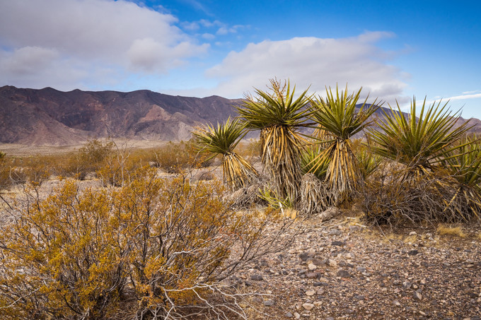
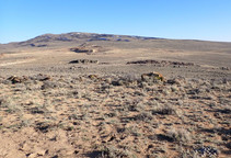
The Old Spanish National Historic Trail extends 2,700 miles across New Mexico, Colorado, Utah, Arizona, Nevada, and California to link Santa Fe and Los Angeles.

The Old Spanish National Historic Trail recognizes the land route traveled by traders from 19th-century Mexico - today's New Mexico - and California. From 1829 to 1848, this trail was the shortest-known route from Santa Fe to Los Angeles, through red-rock mesas, below snow-capped peaks, and fording untamed rivers, following a loose network of Native American footpaths across the Colorado Plateau and Mojave Desert. About 128 miles of the Old Spanish National Historic Trail crosses through the Barstow Field Office.

Today, Bureau of Land Management and National Park Service jointly manage the Old Spanish National Historic Trail. The hazardous mule trade route stands as a testament to the epic story of the West, the struggles early frontiers-people faced in the transport of goods, and the critical ties between the international economics and cultures of North America’s opposite coasts in the mid-1800’s.

Source: BLM NPS

facebooktwitterflickryoutubeinstagramtumblr