|
View as a webpage
|
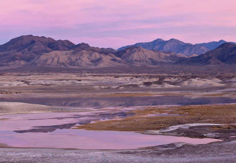
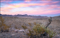
Kingston Range Wilderness, Needles Field Office
|
|
ISSUE 970- October 1, 2021
|
|
|
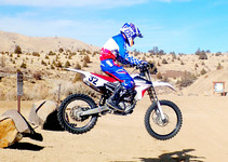
BLM celebrates its partnership with California State Parks, Off Highway Motor Vehicle Recreation Division
The Bureau of Land Management kicks off October by celebrating the California State Parks, Off-Highway Motor Vehicle Recreation Division’s 50th anniversary of work in creating opportunities for high-quality outdoor recreation, preserving the state's extraordinary biological diversity and protecting its most valued natural and cultural resources. (BLM CA News Release)
|
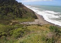
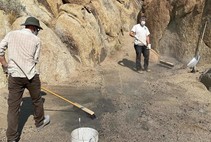
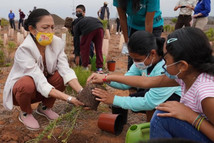
Volunteers welcome at National Public Lands Day project at Lost Coast Headlands
Volunteers are welcome to join staff from the BLM, Saturday, Oct. 2, for a National Public Lands Day cleanup event at the Lost Coast Headlands site overlooking the Pacific Ocean west of Ferndale. Anyone interested should meet at 10 a.m. at the former U.S. Navy Station just south of Centerville Beach. Public lands enthusiasts will work in teams to remove non-native plants, clean up litter and complete other spruce-up projects at the trailheads and along trails. (BLM CA News Release)
|
A huge thank you to all the volunteers who came out to the Alabama Hills for National Public Lands Day!
We installed signs on the west side of movie road, removed 20 fire rings, and collected multiple garbage bags full of trash! What an awesome day with all of our volunteers and partners. (Eastern Sierra Interpretive Association)
|
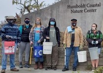
How did you celebrate Coastal Clean Up Month and National Public Lands Day?
Our super star volunteers collected buckets full of marine debris and litter out of the Bureau of Land Management’s Ma-le’l South and the Humboldt Coastal Nature Center Beaches. A little elbow grease and lots of love goes a long way for our marine critters. (Friends of the Dune Facebook)
|
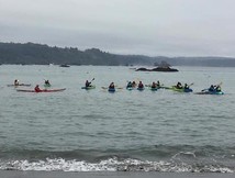
There sure was a lot of appreciation flowing for Trinidad this weekend!
In collaboration with the Trinidad Gateway - California Coastal National Monument and California Coastal Commission Whale Tail Grant, we successfully provided the opportunity for 45 community members to paddle in Trinidad Bay for FREE in honor of Trinidad Appreciation Weekend! Otters, seals, sea lions, seabirds, and bull kelp galore were enjoyed. Viewing the rocks that make up the California Coastal National Monument in Trinidad from a kayak is a unique and awe inspiring experience. (Trinidad Coastal Land Trust Facebook)
|
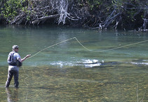
Did you know....Over 99% of BLM-managed lands are open to hunting and fishing. The Bureau of Land Management provides important access to hunting and fishing opportunities on public lands and waters, working with local communities and our valued partners to actively expand access to these opportunities. (BLM Instagram)
|
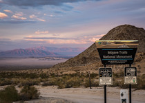
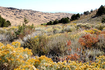
California's Rodman Mountains Wilderness
Colorful escarpments, white mountains splotched with red and black, a maze of canyons, and majestic bajadas come together in California's Rodman Mountains Wilderness. From northwest to southeast across the middle of the area, a large lava flow forms a long mesa that slices the terrain in two. (BLM Instagram)
|
BLM Northern Calif. District Resource Advisory Council to meet virtually
Members of the BLM’s Northern California District Advisory Council will discuss a wide range of natural resource management topics, when they meet virtually via Zoom on Friday, Oct. 8, from 8 a.m. to noon. Members of the public are welcome to participate, and can provide comments to the council at 11 a.m. (BLM CA News Release)
|
California Desert District Advisory Council to meet virtually
The BLM California Desert District Desert Advisory Council (DAC) will meet virtually via Zoom this Saturday, Oct.2, from 9 a.m. to 4:30 p.m.
Meeting agenda topics include national monument planning, a discussion on subgroups, and updates on bighorn sheep and a presentation about desert springs, as well as overviews from the district, field offices, and fire and fuels operations. The meeting is open to the public and participants must register prior to attending at https://bit.ly/3ihCw8F. (BLM CA News Release)
|

BLM seeks Desert Advisory Council nominations
The Bureau of Land Management California Desert District is seeking public nominations for two open positions to serve on the Desert Advisory Council, a citizen-based advisory body that develops recommendations for the BLM related to public land management issues. Applications for future openings are also encouraged. (BLM CA News Release)
|

Leave No Trace Guidance for Recreating in Restoration Areas
This Leave No Trace information is designed to provide guidance for recreating in areas that are undergoing restoration efforts. Climate change, catastrophic wildfire, bark beetle infestation, invasive species, record droughts, and other stressors threaten the health of our forest and watersheds, and the people that rely on them. As areas affected by such stressors undergo natural or agency-led restoration efforts, following the recommendations can help protect you and the land. (Leave No Trace Web)
|
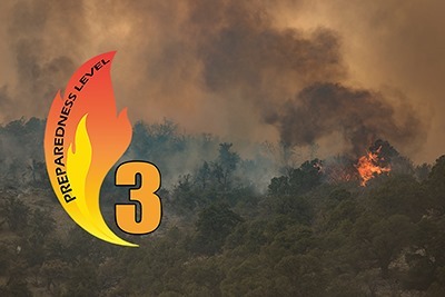
After 99 days at #PreparednessLevel 4 and/or PL 5, the National Multi-Agency Coordinating Group, or NMAC, has moved to PL 3. There is still a lot of work to be done in multiple geographic areas and potential for new fires, but NMAC expects fire activity and #FirefightingResources committed to continue to decline in the coming weeks. (BLM Fire Facebook)
|
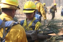
Thank you ARNORTH for your wildland fire ground operations support in California!
Approximately 200 Soldiers from the 23rd Brigade Engineer Battalion and the 2-3 Infantry Battalion, both from the 1-2 Stryker Brigade Combat Team, 7th Infantry Division, I Corps, who supported the Dixie Fire in Northern California, returned to Joint Base Lewis-McChord, Washington after a month-long mission that began August 30. #FirefightingResources #FireYear2021 (NIFC Facebook)
|
BLM California fire restrictions
BLM California fire restrictions or temporary public land closures reduce the risk of wildfires and protect the public. Often times, these preventative measures focus on human-related activities, such as campfires, off-road driving, equipment use and recreational target shooting, since human-related activities are the number one cause of a wildfires. Many BLM California offices have issued seasonal fire restrictions. (BLM CA Web)
|
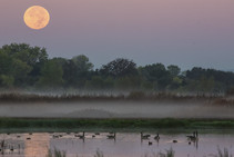
#DYK that the Central Valley is the most important waterfowl wintering area in the Pacific Flyway?
The Pacific Flyway is one of four major North American migration routes for birds, especially waterfowl, and extends from Alaska and Canada, through California, to Mexico and South America. Each year, birds follow ancestral patterns as they travel the flyway on their annual north-south migration. Along the way, they need stopover sites such as wetlands with suitable habitat and food supplies.
What percent of the Pacific Flyway's migratory bird population does the Central Valley support?
A) 35% B) 60% C) 85% D) 40% Keep scrolling to find out!
|
|
BLM ANNOUNCES WINNERS OF THE 2021 STEWARDSHIP AWARDS
In recognition of exemplary rangeland management and outstanding accomplishments in restoring and maintaining the health of public rangelands, the Bureau of Land Management has named two permittees and two collaborative teams as recipients of the 2021 Rangeland Stewardship and Sagebrush-Steppe Stewardship awards. (BLM News Release)
|
Secretary Haaland Highlights Biden Administration Conservation Efforts in Visit to National Wildlife Refuge
Secretary of the Interior Deb Haaland visited the U.S. Fish and Wildlife Service’s San Diego National Wildlife Refuge to discuss the important conservation work of urban wildlife refuges, highlight the America the Beautiful initiative, and honor Hispanic Heritage Month. (DOI News Release)
|

This Week at Interior October 1, 2021
The latest Landsat lifts off as Secretary Haaland looks on; the Secretary visits the San Diego National Wildlife Refuge to discuss conservation, highlight the America the Beautiful initiative, and honor Hispanic Heritage Month; the oldest known human footprints in North America have just been un-earthed at White Sands National Park in New Mexico; Interior restores protections under the Migratory Bird Treaty Act to reduce the number of human-caused bird mortalities. (DOI YouTube)
|
|
Question of the Week Answer
Answer: B) The Central Valley is the most important waterfowl wintering area in the Pacific Flyway, supporting about 60 percent of the total population of migratory birds. In the Sacramento Valley, rice fields provide habitat and food for migrating waterfowl and the shorebirds that nest in the fields year-round.
In California, 90 percent of historic wetlands have been lost. Many of these sites are impacted by development and other factors that threaten to affect the viability of the entire flyway. Wetlands provide critical wintering habitat for millions of migrating waterfowl, including geese and ducks. The open water and vegetation in wetlands provide food, rearing areas and cover for waterfowl and shorebirds. One of the few remaining wetlands left in the Southern San Joaquin Valley, BLM's Atwell Island Project is an important area for migratory waterfowl, shorebirds, songbirds and other water birds in the Central Valley providing opportunities to enjoy wildlife viewing, nature study and photography, particularly during the fall migration. Sources: Water Education Foundation, BLM
|
|
|
|
News.Bytes is a publication of the Bureau of Land Management in California.
Bureau of Land Management
California State Office
2800 Cottage Way, Suite W1623
Sacramento, CA 95825
(916) 978-4600
Send comments to the News.Bytes Team | Subscribe to News.Bytes | Unsubscribe
|
     
|
|
|