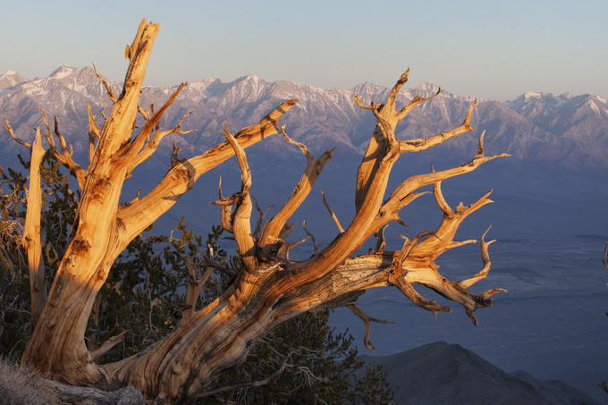
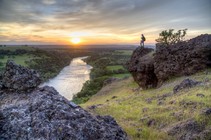
Inyo Mountain Wilderness, Bishop Field Office
|
|
ISSUE 939- February 26, 2021
|
|
|
 |
|
National Invasive Species Awareness Week
The Bureau of Land Management manages 245 million acres of public lands primarily in the Western United States, including Alaska. Seventy-nine million of these acres are impacted by noxious and invasive weeds. One of BLM's priorities is ecosystem health and one of the greatest obstacles to achieving this goal is the rapid expansion of weeds across public lands. These invasive plants can dominate and often cause permanent damage to natural plant communities. (BLM Website)
|
 |
|
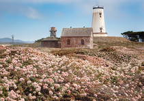
Volunteers return native plants to the landscape
The Piedras Blancas Light Station at the California Coastal National Monument was once covered by invasive, non-native plants. The effort to remove these invasive plants began in 2002 and required years of hard work by dedicated volunteers. Over 800 tons of iceplant have been removed from the Piedras Blancas Light Station and native plants are thriving. Thanks to more than 40,000 volunteer hours of labor, we now see native flowers year-round. (BLM CA Facebook)
|
 |
|
Stinkwort gets pulled to protect native species
At the Pine Hill Preserve Area of Critical Environmental Concern, staff, interns, and volunteers pull stinkwort (Dittrichia graveolens), a relatively new invasive species, to enhance the rare plant habitat. Native plants can get crowded out by non-native species. Stinkwort invades cleared spaces and like other plants in the sunflower family (Asteraceae), it spreads on the wind. It is one of the latest worrying threat to this diversity hotspot. Learn more about the Pine Hill Preserve. (BLM CA Website)
|
 |
|
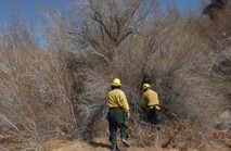
Removing Tamarisk to improve habitats
Since 2005, the Barstow Field Office, along with many of our conservation partners, have been engaged in an intensive Tamarisk (Saltcedar) management effort on the Amargosa and Mojave Rivers. Over the years we have removed this invasive species from hundreds of acres of riparian habitat. (BLM CA Facebook)
|
 |
|
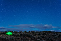
Stargazing on public lands
Preparing for your next adventure on public lands? This Spring would be an ideal time to do some stargazing and enjoy the night sky from Massacre Rim in northwest Nevada. In 2019, the International Dark-Sky Association named Massacre Rim, managed by BLM California, one of the darkest places on Earth. For stargazing tips, local history and to download maps, visit the BLM CA website.
|
 |
|
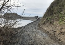
Trail reopens at Black Sands Beach
The Black Sands Beach Trailhead at the King Range National Conservation Area, inundated by a flood from the Humboldt Creek in January, has been reopened. Recent rains have flushed open the drainage channel allowing the creek to flow into the ocean. King Range NCA staff worked diligently this week to restore and stabilize the trail. Visitors to the Lost Coast may now safely access the Black Sands Beach. For more information, please call the King Range Project Office at: (707) 986-5400 (BLM CA Website)
|
 |
|
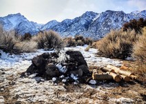
Safety around the campfire
In just one day staff from the Alabama Hills found 4 unattended fires that were left to smolder and potentially reignite by campers. It’s cold to be dispersed camping! If you decide to have a campfire to stay warm, make sure to be fire safe. Get your California campfire permit, use existing fire rings and make sure your campfire is out before you head to your sleeping bag and before you leave your camp for good. For campfire safety tips, check out this tip sheet.
|
 |
|
Let's get primitive!
Want to learn more about primitive or dispersed camping on BLM public lands? This is the first article in our Get Primitive series where we give you the basics on how to get out on your public lands in locations far less developed than others. Stay tuned over the next couple months as we highlight some lesser-known hidden gems in California! (BLM Medium Blog)
|
 |
|
Know before you go
Travel conditions can vary greatly from the time you leave your home to reaching your destination, especially in the mountain passes and at higher elevations. It’s important to check road conditions before heading out and make sure you pack the right gear in your car in case you run into issues. (BLM CA Recreate Responsibly Tips)
|
 |
|
Interior Department welcomes newest members of leadership team
The Department of the Interior today announced additional members of the agency leadership team working to steward America's natural, cultural and historic resources, and honor our nation-to-nation relationship with Tribes. (DOI News Release)
|
 |
|
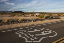
Historic Route 66 in California receives National Scenic Byway status
The Bureau of Land Management Barstow and Needles Field Offices are thrilled to share that the Historic Route 66 between Needles and Barstow is officially one of America’s Byways. The Federal Highway Administration National Scenic Byways Program announced the designation of the California Historic Route 66 Needles to Barstow Scenic Byway last week. (BLM CA News Release)
|
 |
|
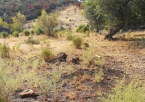
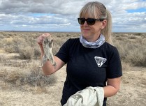
BLM Biologists study central valley squirrel species
The San Joaquin Antelope Squirrel or Nelson's Antelope Squirrel, found in the San Joaquin Valley. Biologists from the Bakersfield Field Office recently collected data and measurements from 95 squirrels which will be used to learn more about the species and assist with the species sustainability and recover. (BLM CA Facebook)
|
 |
|
Join the civil engineering team at BLM
Looking for work as a Civil Engineer? The Bureau of Land Management is looking to recruit and quickly fill multiple Civil Engineer positions located in the following locations: Alturas, Arcata, Susanville, Cedarville, Redding OR Sacramento, CA. (USAJOBS Website)
|
 |
|
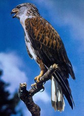
True or False: The Ferruginous hawk have legs that are covered in feathers.
Keep scrolling to find out!
Photo courtesy of CDFW
|
 |
|
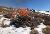
Prescribed fire helps reduce wildfire risk
Crews from the Applegate field office took advantage of good weather conditions to continue pile burning projects at Board Corral, an area of public land in northern Washoe County near the boundary with the Sheldon National Wildlife Refuge. The piles of juniper limbs and small trees were created in projects to improve range conditions for wildlife and livestock grazing and to help reduce the potential for catastrophic wildfire. (BLM CA Facebook)
|
 |
|
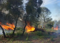
BLM to oversee Pine Hill Preserve controlled pile burn
The Bureau of Land Management Mother Lode Field Office will oversee a controlled prescribed burn of roughly 200 piles to begin this week on approximately 20 acres in the Cameron Park Unit of the Pine Hill Preserve in El Dorado County. Burn operations may continue periodically through the spring depending on weather, air quality and resource availability. Smoke may be visible in Cameron Park, El Dorado Hills, Shingle Springs and along U.S. Highway 50. (BLM CA Website)
|
 |
|
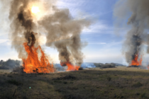
Prosper Ridge Prairie Restoration Project at King Range NCA
The Bureau of Land Management, the Six Rivers National Forest, and local fire crews took advantage of ideal winter weather conditions to burn piles in the coastal prairies of Prosper Ridge in the King Range National Conservation Area. Prosper Ridge is southwest of Petrolia, California at the northern end of the Lost Coast. (BLM CA Facebook)
|
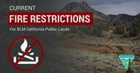
Don't let your guard down just because it's cold! Some fire restrictions still in effect
There's still fire danger in some parts of the state. Avoid activities that could spark a wildfire! Here’s an interactive MAP showing all current fire restrictions. Be sure to bookmark it for future use!
Target shooting and other fire restrictions remain in effect for some areas of BLM-managed public lands in California. Find specific restrictions by field office on our Fire Restriction webpage. Restrictions on target shooting do not prevent hunting with a valid hunting license, as hunting on BLM public lands is managed by the California Department of Fish and Wildlife. Please visit the State website for more information.
|
|
|
|
Question of the Week Answer
True! It is one of the largest of the soaring hawks and is in good company with the Rough-legged hawk and Golden Eagle as the three American raptors that have legs covered in feathers.
The Ferruginous hawk (Buteo regalis) is a truly regal raptor and is one of the largest of the soaring hawks. Ferruginous is a Latin-based word and speaks to the hawk’s rust colored plumage; Buteo, from Latin means hawk and regalis means royal. This stunning hawk can be found wintering throughout many parts of California, including at the Point Arena-Stornetta Unit with some breeding occurring in the upper northeast of the state. It is currently protected under the federal Migratory Bird Treaty Act and is a California Species of Special Concern.
Source: Audubon
|