|
View as a webpage
|

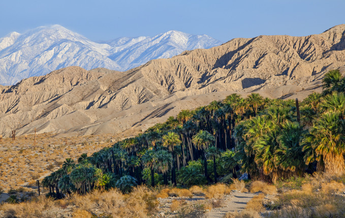
Sand to Snow National Monument, Palm Springs-South Coast and Barstow Field Offices
|
|
ISSUE 937- February 12, 2021
|
|
|
Sand to Snow National Monument's 5th anniversary Nature Hunt - Feb 12-14
Celebrate the anniversary by getting outdoors and joining this special event. People of all ages are invited to participate by using the free iNaturalist smartphone app to identify as many species of plants, animals, and other organisms as possible along designated National Monument trails. For full details or to register, check out the event flyer! (BLM CA News Release)
|
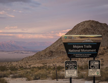
Social media takeover this weekend - Mojave Trails National Monument
In celebration of the 5th anniversary of the Mojave Trails National Monument designation, BLM California will be having a social media takeover this Friday through Sunday. You’ll see many beautiful photos and learn some interesting facts about the Mojave Trails, Route 66 and more! Be sure to follow us on your favorite social media platform: BLM CA Facebook BLM CA Twitter
|
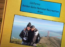
Every year for Valentine’s Day we welcome the hundreds of pictures and videos of engagements, weddings, and all the special moments you’ve shared at national parks, wildlife refuges, and other locations in the great outdoors. It’s our pleasure to present just a small sample of all the love we received this year, and we thank everyone for sharing! (Video from the Department of Interior)
|
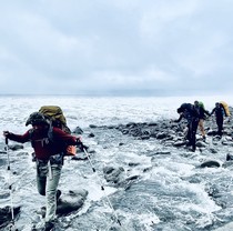
Hazardous conditions for hikers on the Lost Coast Trail
Visitors to the Lost Coast Trail have been faced with hazardous coastal conditions as winter storms wash over the King Range National Conservation Area. With swells frequently reaching heights above fifteen feet, an increased number of hikers have reported being caught off-guard and struck by sneaker waves (large waves which surge up unexpectedly). Sneaker waves can be hazardous, and all visitors are urged to practice extreme caution! Where possible postpone travel if inclement weather is predicted during your scheduled trip, as hiking along the Lost Coast Trail is not advised during winter storms. Photo-M. Barauskas (BLM CA Facebook)
|
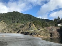
Black Sands Beach Trailhead continues to be temporarily inaccessible due to flooding
Visitors travelling to the King Range National Conservation Area are advised that the Black Sands Beach Trailhead is currently flooded and may not be accessible. Due to safety concerns and impacts to the Lost Coast's landscape and resources, visitors are urged not to climb over railings, scale the steep coastal bluffs, or attempt to access unmarked trails. (BLM CA Twitter)
|
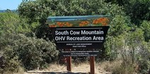
Precipitation causes temporary closure at northern California OHV recreation area
The South Cow Mountain OHV Management Area is temporarily closed due to heavy precipitation and poor road and trail conditions. For more information, call (707) 468-4000. (BLM CA Website)
|
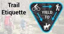
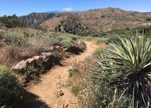
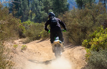
The Yield Triangle - the standard of yielding while on the trails
When you're out on the trail, remember to practice trail etiquette and respect your fellow trail users. You may see yield signs along the way. Remember: cyclists yield to hikers, and everybody yields to horses. (Leave No Trace)
|
Caltrans District 2 recognizes local Adopt-A-Highway program volunteers
The second largest natural freshwater lake in California, Eagle Lake is well known for its fish and wildlife and attracts visitors who enjoy water sports, fishing, and swimming. Unfortunately, the lake’s shoreline and adjacent shoulders of the highway are susceptible to litter and if left unchecked, it could effect the ecosystem of Eagle Lake, Caltrans continued. “This is why we’re so thankful for Stan Bales, an Outdoor Recreation Planner for the Bureau of Land Management – California Eagle Lake Field Office, and his team. They have worked hard to clean a 6-mile stretch of State Route 139 that runs along the north end of Eagle Lake for over 23 years! (Lassen County times)
|
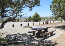
Have you dreamed of becoming a camp host?
Outdoor enthusiasts have the opportunity to live and work in a beautiful northern California outdoor setting as volunteer camp hosts for the Bureau of Land Management. The BLM needs campground hosts at Douglas City, Steel Bridge and Junction City campgrounds along the Trinity River west of Redding. The camping season runs from May to November. (BLM CA Website)
|

BLM takes next steps on proposed Crimson Solar Project
The BLM took the next step toward issuing a decision for a proposed solar project on public lands near Blythe in Riverside Co. When completed, the Crimson Solar Project would generate 350 megawatts of clean electricity, enough to power 87,500 homes. (BLM CA News Release)
|
Interior announces plans to strengthen LWCF
The Interior Department today took steps to strengthen the Land and Water Conservation Fund (LWCF) by rescinding Trump administration policies that significantly undermined the landmark conservation program. Secretarial Order 3396 revokes an order signed on November 9, 2020 (Secretarial Order 3388) that unilaterally imposed new restrictions to inhibit the availability of LWCF funding for federal land and water acquisitions. (DOI News Release)
|
Interior announces series of Tribal consultation in recognition of the importance of nation-to-nation relationship
The Department of the Interior announced today that it will host initial consultations with Tribal leaders next month. In addition to honoring and strengthening the nation-to-nation relationship, these steps will help ensure that future White House and Interior efforts at addressing the four converging crises of our time – COVID-19, economic security, racial justice and climate change – are inclusive of Tribal Nations’ priorities and recommendations. (DOI News Release)
|
BLM and US Forest Service seek public input on OHV recreation on public lands
The Bureau of Land Management will hold three virtual public meetings to solicit input for grant applications to support off-highway vehicle recreation on public lands within the jurisdictions of the Bakersfield and Ukiah field offices, as well as within the boundaries of the Bishop Field Office in conjunction with the Inyo National Forest. (BLM CA News Release)
|
BLM Eagle Lake Field Office to hold virtual public meeting on OHV grant proposals
Anyone interested in off-highway vehicle sports on northeast California public lands managed by the Bureau of Land Management’s Eagle Lake Field Office can share suggestions for projects or improvements that would benefit from grant funding, when the BLM holds a virtual public meeting, Thursday, Feb. 11, at 5 p.m. Participants must register in advance. (BLM CA News Release)
|
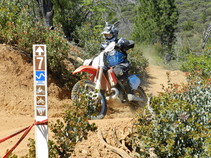
BLM Redding Field Office accepting comments on OHV grant proposal
The Bureau of Land Management’s Redding Field Office will hold a virtual public meeting and is accepting public comments regarding grant funding proposals that would benefit off-highway vehicle recreation on public lands in northern California. The virtual meeting is scheduled for Monday, Feb. 22, at 5 p.m., via Zoom. Those interested in participating must register in advance. (BLM CA News Release)
|
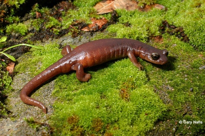
What is the home range of the Limestone Salamander?
A. 30 feet
B. 75 feet
C. 150 feet
D. 300 feet
Keep scrolling to find out!
Photo courtesy of California Herps
|
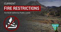
Don't let your guard down just because it's cold! Some fire restrictions still in effect
There's still fire danger in some parts of the state. Avoid activities that could spark a wildfire! Here’s an interactive MAP showing all current fire restrictions. Be sure to bookmark it for future use!
Target shooting and other fire restrictions remain in effect for some areas of BLM-managed public lands in California. Find specific restrictions by field office on our Fire Restriction webpage. Restrictions on target shooting do not prevent hunting with a valid hunting license, as hunting on BLM public lands is managed by the California Department of Fish and Wildlife. Please visit the State website for more information.
|
|
|
|
Question of the Week Answer
The answer is D. 300ft! The Limestone salamander, or Hydromantes brunus, is not known to move more than 100 meters, or 330 feet. They are a member of the family Plethodontidae, the Plethodontid or Lungless Salamanders. Plethodontid salamanders do not breathe through lungs. They conduct respiration through their skin and the tissues lining their mouth. This requires them to live in damp environments on land and to move about on the ground only during times of high humidity. (Plethodontid salamanders native to California do not inhabit streams or bodies of water but they are capable of surviving for a short time if they fall into water.) These salamanders inhabit mossy limestone crevices and talus in the Grey Pine, Oak, Buckeye, Chaparral belt of the lower Merced River Canyon, typically on steep slopes. They can be found along the Merced River from Lake McClure to about 4 miles NE of Briceburg, Mariposa County. They also occur along the Merced River tributaries including Bear Creek and its feeder creeks, south of Briceburg, some have even been found in abandoned mine tunnels. When threatened, this salamander has been observed coiling and rolling downhill to escape.
Source: California Herps
|
|
|
News.Bytes is a publication of the Bureau of Land Management in California.
Bureau of Land Management
California State Office
2800 Cottage Way, Suite W1623
Sacramento, CA 95825
(916) 978-4600
Send comments to the News.Bytes Team | Subscribe to News.Bytes | Unsubscribe
|
     
|
|
|