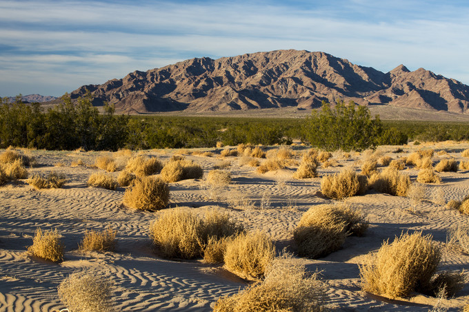
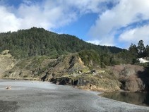
Cadiz Dunes Wilderness, Mojave Trails National Monument, Needles Field Office
|
|
ISSUE 936- February 5, 2021
|
|
|
Sand to Snow National Monument's 5th anniversary Nature Hunt - Feb 12-14
Celebrate the anniversary by getting outdoors and joining this special event. People of all ages are invited to participate by using the free iNaturalist smartphone app to identify as many species of plants, animals, and other organisms as possible along designated National Monument trails. For full details or to register, check out the event flyer! (BLM CA News Release)
|
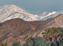
Celebrate these stunning California Desert Monuments with a road trip
Next week marks the anniversary of a big day for US public lands. Five years prior, on February 12, 2016, President Barack Obama extended national monument designation to three Mojave Desert sites in eastern California: the Mojave Trails, Sand to Snow, and Castle Mountains. Collectively, these areas make up the California Desert Monuments, encompassing 1.8 million acres of desert landscape originally inhabited thousands of years ago by the Chemehuevi, Kawaiisu, Mohave, Serrano, Cahuilla, Southern Paiute, and other Native American tribes. (Matador Network)
|
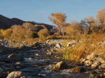
Free Flowing: Whitewater River’s governmental protections ensure no forces dam it
Desert dwellers out for a refreshing splash in Whitewater River on a hot day may give no thought to the higher source of their recreation. The headwaters of the river’s South Fork lie a mere 100 feet below the 11,503-foot peak of Mount San Gorgonio in the Sand to Snow National Monument. (Palm Springs Life)
|
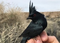
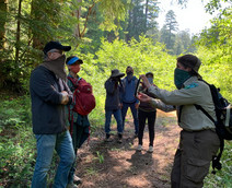
Campfire Talk: Discover the birds of Mojave Trails National Monument - Feb 9
Join our celebration of the fifth anniversary of Mojave Trails National Monument with a special virtual talk on birding and citizen science! Bureau of Land Management wildlife biologist Chris Otahal will talk about the different avian species in Mojave Trails National Monument and share his favorite bird watching spots. Both beginner and seasoned birders are welcome! (Facebook Event)
|
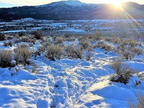
Winter recreation in California's high desert provides visitors with stunning views
Last week's snowstorm created some beautiful sights on public lands of northeast California's high desert, especially for those who clipped on their cross-country skis to get to good vantage points. And with great opportunities for solitude, social distancing was not an issue. This view was from Antelope Mountain, overlooking Susanville and the west edge of the Honey Lake Valley. (BLM CA Facebook)
|
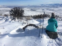
Cross-country skiing through the Bald Mountain trail network
When we built the Bald Mountain Trail Network on the sage-dotted slopes near Janesville, we had hikers, horseback riders and mountain bikers in mind. The BLM was thrilled over recent days when we discovered that the trails also appeal to cross-country skiers who were enjoying a rare opportunity to ski in the high desert. Bald Mountain is in the Honey Lake Valley, at the western edge of the Great Basin. (BLM CA Website)
|
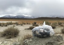
Pack out your trash and leave no trace!
Another weekend means another clean up at the Bureau of Land Management's popular Whitmore Hot Springs area in Long Valley. The harsh and saddening reality for our many visitors is the recurrence of trash, food debris, plastic, hygiene products, forgotten towels, human waste, toilet paper and as of late, masks. Not only does this change a visitor’s experience but it negatively impacts the behavior of wildlife essential to a healthy ecosystem. (BLM CA Facebook)
|
Black Sands Beach Trailhead temporarily inaccessible due to flooding
Visitors travelling to the King Range National Conservation Area are advised that the Black Sands Beach Trailhead is currently flooded and may not be accessible. Due to safety concerns and impacts to the Lost Coast's landscape and resources, visitors are urged not to climb over railings, scale the steep coastal bluffs, or attempt to access unmarked trails. (BLM CA Facebook)
|
The BLM implements mask requirement in all facilities and buildings
To protect the health of those who live, work and visit BLM-managed public lands and facilities, and in support of President Biden’s Executive Order on Protecting the Federal Workforce and Requiring Mask-Wearing, the Bureau of Land Management is immediately implementing a mask requirement for employees, visitors, partners and contractors in all BLM facilities and buildings. Additionally, masks are required outdoors on public lands where physical distancing is not feasible. (BLM News Release)
|
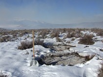
BLM to conduct prescribed fire operations in Mono County
Wildland fire crews from the Bureau of Land Management Bishop Field Office are planning winter pile burning operations with interagency partners for areas northeast and southeast of Lee Vining in Mono County, when weather and air quality conditions permit. Slash piles composed of limbs, branches and trees will be burned across 65 acres of public land in the Bridgeport Canyon area north of Mono Lake. (BLM CA News Release)
|
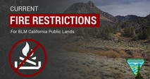
Don't let your guard down just because it's cold! Some fire restrictions still in effect
There's still fire danger in some parts of the state. Avoid activities that could spark a wildfire! Here’s an interactive MAP showing all current fire restrictions. Be sure to bookmark it for future use!
Target shooting and other fire restrictions remain in effect for some areas of BLM-managed public lands in California. Find specific restrictions by field office on our Fire Restriction webpage. Restrictions on target shooting do not prevent hunting with a valid hunting license, as hunting on BLM public lands is managed by the California Department of Fish and Wildlife. Please visit the State website for more information.
|
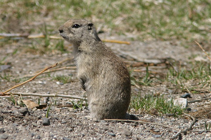
True or False? The Mojave ground squirrel builds nests in underground burrows that can be up to 1 meter deep?
A. True
B. False
Keep scrolling to find out!
|
Interior Department announces additional members of leadership team
The Department of the Interior today announced additional members of agency leadership who will work to address the climate and nature crises and advance President Biden’s vision to build a clean energy future that creates good-paying jobs and powers our nation. (DOI News Release)
|
BLM and Forest Service announce 2021 grazing fees
The Federal grazing fee for 2021 will be $1.35 per animal unit month for public lands administered by the Bureau of Land Management and $1.35 per head month for lands managed by the USDA Forest Service. (BLM News Release)
|
|
|
|
Question of the Week Answer
The answer is A. True! The Mojave ground squirrel builds nests in a burrow system, which may be as long as 6 meters (20 feet), and as deep as 1 meter (3.3 feet). They prefer sandy to gravelly soils and avoids rocky areas. They are usually active above ground in the spring and early summer.
California is home to 27 species of squirrels and two of those species, the Mojave ground squirrel and Nelson’s antelope squirrel, exist nowhere else!
Source: CA Dept. of Fish and Wildlife
|