|
The new and improved DC Flood Risk Portal, developed by the DC Department of Energy & Environment (DOEE), uses the location of tweets about flooding to share real-time information on flood hazards and better understand flood risk. Through geo-tagged tweets that mention key words such as “flooding,” the Portal populates an interactive map with instances of flood damage experienced by community members.
 Source: Getty Image.
Crowdsourcing the location of flood impacts through social media can help the District and its residents identify, prepare for and recover from flood events. It is important for residents to be aware that flood risk exists outside of the FEMA-mapped floodplain. Seeing where flooding is happening in real time, which may include instances of flooding outside of the Special Flood Hazard Area, can help illustrate where flood risk exists and communicate the importance of preparedness.
As flood risk evolves over time, the flood risk information compiled through the Portal can also help District partners pinpoint areas that may benefit from mitigation efforts. The District and its partners can analyze the geo-located tweets to search for trends, and areas with an increased flood risk can be targeted for mitigation action.
 Screenshot of MEMA’s virtual open house.
To support their 2021 state Hazard Mitigation Plan (HMP) update, the Maryland Emergency Management Agency (MEMA) is hosting a 360° virtual open house. Due to the ongoing pandemic, community and state partners can’t meet in person this year. The virtual space will help communities participate in the plan update by giving them an interactive way to leave comments and review materials.
Community partners can click on color-coded banners that lead to documents, maps, videos and useful information on hazard threats, critical facilities and state-owned facilities. The banners are color-coded based on region, and a wall map shows which region is assigned to each color. Community partners can also click on the comment box on the table, which leads to a hazard identification and risk assessment survey. The survey helps MEMA identify missing information or local areas of concern that should be addressed.
Users can navigate the virtual space as follows:
- Click around on various points in the room.
- Use the directional menu at the bottom to rotate the room.
- Areas with information are indicated with an arrow above them.
- From there, maps and other documents can be shared and downloaded to the user’s computer.
The state HMP update benefits from participation from all communities, which will help develop long-term plans that help the state become more resilient to disasters.
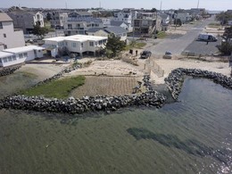
The City of Chesapeake, Virginia has partnered with two nonprofit organizations, Wetlands Watch and Living River Trust, to find a cost-effective way to maintain floodprone properties that were acquired by the city with FEMA funding. The partnership aims to transfer ownership of these properties to a land trust for long-term maintenance.
To help mitigate flood damage, local governments can apply for federal funds to purchase properties that are repeatedly damaged from flooding events. Federal assistance can be a lifeline for distressed homeowners and can be used to repurpose land and mitigate the impacts of repeat flooding. Once the land is purchased, however, local governments find that maintaining the land can be expensive. In addition, complicated codes and regulations make it difficult to transfer ownership to conservation organizations with a mission of maintaining open space.
 Source: Getty Image.
Over the past 15 years, the City of Chesapeake has purchased more floodprone properties with FEMA funds than any other community in the Commonwealth - utilizing around $11.5 million in Hazard Mitigation Assistance (HMA) grant funding to acquire 38 floodprone parcels. Maintenance costs for this acquired land currently exceed $2,000 per month per parcel, adding up to a significant cost for the city.
To reduce the cost to the city, Chesapeake is piloting an innovative partnership with the Living River Trust. The partnership aims to transfer ownership of the land from the city to the land trust. This represents a non-traditional arrangement for the Living River Trust, which typically acquires conservation easements restricting the use of land, rather than full ownership. If the pilot is successful, the partnership aims to transfer this solution to other nearby communities, creating a cost-effective solution for floodprone properties.
 The Wharf on the Potomac River in Southwest DC, courtesy of DDOE.
The DOEE will soon award its second High Water Mark Project grant to fund a public art project that communicates information about flood risk. The goal of the grant, which was released in January 2021, is to build resilience to future flooding by raising awareness of flood risk among DC residents.
Funding for the grant program comes from FEMA’s Community Assistance Program - State Support Services Element, and DOEE’s Stormwater Enterprise funds. The recipient of the grant will design, produce and install a high-quality, cost-effective and unique High Water Mark visual presentation at the Wharf in Southwest Washington, DC. Once complete, the new High Water Mark project will become one of three High Water Mark installations across the District, adding to two previously installed projects in Kingman Island and Marvin Gaye Park. Produced by DC-based artists, the two existing sculptures use color-coded pill shapes and spheres to show historic and projected flood depths.

FEMA Region 3 and state partners are working to build local capacity through Plan Implementation and Grant Development (PIGD) workshops. These workshops are targeted at helping local officials connect the dots between Hazard Mitigation Planning and HMA grant application development.
In December 2020, Pennsylvania piloted a two-day virtual PIGD workshop for local officials in and near Cambria County. The first day of this workshop focused on providing an overview of Hazard Mitigation Planning and Hazard Mitigation Assistance, and the second day focused on grant eligibility requirements, scope of work best practices, and identifying new and existing funding opportunities to address community needs. Throughout this workshop, FEMA, state partners and other relevant stakeholders presented and provided insight on the grant application process. There were also breakout sessions focused on topics including benefit-cost analysis, environmental historic preservation and the grant application development process.
Overall, the pilot was successful and will help inform future workshops. Tom Hughes, Pennsylvania State Hazard Mitigation Officer, explained that one of the key aspects that helped make this workshop a success was the state’s partnership with Cambria County in hosting the event. The county did an excellent job in getting the word out about the workshop and encouraging attendance, and stakeholder involvement will be emphasized for future events. Hughes also said that this year Pennsylvania received the most non-disaster grant applications ever, and many of the applications can likely be attributed to the guidance provided at the PIGD workshop. This workshop provided momentum in Pennsylvania, and the state plans to replicate the PIGD workshop in other locations throughout 2021.
|
FEMA Region 3 is hosting a webinar series for hazard mitigation planners and other partners interested in reducing risk in their communities. These “Coffee Breaks” are hour-long webinar sessions hosted every other month to provide mitigation best practices and highlight the work happening at federal, regional, state, and community levels to reduce risk across the region.
The Coffee Breaks are open to everyone involved in hazard mitigation, resiliency, or risk reduction planning in the public and private sectors, which includes community planners, emergency managers, floodplain managers, GIS technicians, government officials, contractors, and anyone else involved in the development and implementation of hazard mitigation and risk reduction strategies.
Please note: Webinar log in/call in information will be sent out several days prior to the date of the Coffee Break.
Participants who are Certified Floodplain Managers (CFM) through Association of State Floodplain Management (ASFPM), or are American Institute of Certified Planners (AICP) certified through the American Planning Association (APA), may be eligible to receive 1 Continuing Education Credit.
Exploring Approaches to Plan Integration
May 5, 2021 11AM ET - 12PM ET
Plan Integration can be an overwhelming challenge: What tier of plans should I address: local, county, or planning district? How many of those plans within that tier should I review? What connecting questions should I ask about these plans? Are there any resources to assist me in this process? Please join us for our May Coffee Break to dive into these questions about plan integration approaches, as well as potential resources to assist you in this endeavor.
Register for upcoming Coffee Break webinars here:
https://femaregion3coffeebreaks.eventbrite.com
|
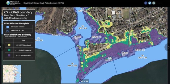 Screenshot of Coast Smart Climate Ready Action Boundary (CS-CRAB).
The state of Maryland has launched a story map highlighting the Coast Smart Climate Ready Action Boundary (CS-CRAB). Through images, maps and descriptions, the story map explains the Climate Ready Action Boundary and how it informs public development projects in Maryland’s coastal areas. As the story map illustrates, the CS-CRAB boundary shows the areas that would be inundated if a three-foot margin of safety is added to the Base Flood Elevation (BFE).
The CS-CRAB marks the boundary where new state regulations apply. As of September 2020, all applicable projects located waterward of this boundary are required to comply with the state’s Coast Smart practices. State projects and certain state-funded projects within the boundary must be constructed with a minimum of three feet of freeboard above the BFE. The goal of these regulations is to help the state make safe and fiscally wise investments in coastal areas.
In addition to showing the areas subject to state regulations, the CS-CRAB story map shows areas vulnerable to flooding and sea level rise. Local governments and the public can use the story map to explore floodprone areas along the coast. While the Coast Smart regulations only apply to state projects, local governments can use the CS-CRAB story map to implement their own “coast smart” standards for local development.
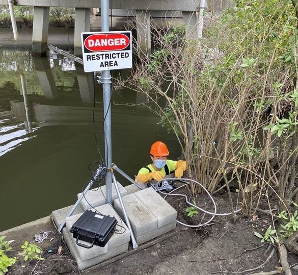 Photo courtesy of RISE.
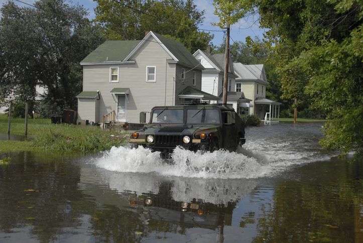
Residents in Norfolk, Virginia are experiencing an increase in flooding due to tide water in the stormwater system. Even after a light rainstorm, areas surrounding storm drains are often covered in flood water.
Data shows that sea level rise is affecting the city’s stormwater management system. Stormwater lines are filled anywhere from 20% to 50% capacity, even when it’s not raining. When it does rain, the water has nowhere to go, and it overwhelms the system.
In order to help the city monitor potentially dangerous stormwater flooding situations and collect data for future flooding solutions, RISE, a Norfolk-based nonprofit organization, has partnered with StormSensor, a stormwater tracking company. RISE works with local partners to find solutions and funding for resilience challenges.
StormSensor collects data by placing sensors in the pipes of areas in the city that often experience flooding. Instead of focusing on street flooding, StormSensor looks at the effectiveness of stormwater systems and sends data to a cloud-based system every five minutes, so flooding situations can be viewed in real time. StormSensor uses the collected data to help the city develop future flooding solutions and improve the city’s stormwater management system.

In this issue of the Resilience Report, we virtually connected with Dr. Phil Berke, a Research Professor with the Department of City and Regional Planning at the University of North Carolina at Chapel Hill, who specializes in land use and environmental planning. Dr. Berke’s work involves the relationship between community resilience and urban planning, specifically focusing on the methods, theory and metrics of local planning and outcomes.
Phil works closely with associates across the county to build resilient communities through important work led by the Coastal Resilience Center, a U.S. Department of Homeland Security (DHS) Center of Excellence. Dr. Berke has partnered with the DHS Science and Technology Coastal Resilience Center of Excellence, the Institute for Sustainable Communities at Texas A&M University, and the American Planning Association (APA) to promote the Plan Integration for Resilience Scorecard™ (PIRS™) as a national standard and resource for building local capacity to integrate resilience across planning sectors.
|
Q: Can you tell us a little more about your day-to-day work toward building more resilient communities?
I am a Research Professor in Chapel Hill – previously with Texas A&M – and I currently serve on multiple advisory boards, including the Urban Institute’s Global Evaluation of the Rockefeller Foundation Global 100 Resilient Cities, the National Science Foundation’s Social Science Extreme Events Reconnaissance Platform, and the Planet Texas 2050 Technical Advisory Board of UT-Austin. My current work is mainly focused on helping communities clear a difficult disaster planning hurdle: integrating all the plans they have – such as those for transportation, parks, economic development, hazard mitigation, emergency management and comprehensive land use – so that the plans work together to reduce vulnerabilities to hazards. This work is done through the development and implementation of the PIRS method.
Q: What is the PIRS and why was it developed?
It started with my involvement on the National Research Advisory Council, where we were trying to assess the level of risk around rising sea level and what to do about that risk throughout the Atlantic and Gulf Coasts. Around that time, Hurricane Sandy ravaged New Jersey and New York. Our work included an assessment of the recovery efforts of this storm. As the only planner on the Council, I wondered if communities were rebuilding in ways that were transformative. I looked at a couple of plans that were adopted right before Hurricane Sandy, such as Hazard Mitigation Plans (HMPs) showing actions and policies in place to allow for buyouts, but then looked at corresponding Comprehensive Plans that promoted development in the exact area marked as repetitive loss. Multiple towns were pushing for more redevelopment along the coast to expand the tax base and increase jobs that were marked in another plan as a buyout zone. I noticed far and wide that plans weren’t congruent. Something needed to be done. From this point, I realized we needed better plan integration, as well as integration of follow-up investments when we rebuild our communities.
We developed the PIRS with the idea that you can spatially evaluate each plan within a community (e.g., HMP, Comprehensive Plan, Transportation Plan, etc.). We analyze plans at a neighborhood scale (e.g., downtown, waterfront) and consider demographics (e.g., race, income). We can use this analysis to determine how well-coordinated plans are in reducing vulnerability and determine if the existing network of plans are targeting the most vulnerable areas (economically and socially).
Q: How exactly does the PIRS work?
Communities are swimming in plans, but they are siloed. We start off by “stacking” plans; meaning we take each plan that a community has adopted and layer them on top of each other to determine if they are increasing or decreasing vulnerability. Planning districts are overlaid with hazard zones and other “mappable areas” to generate scores for each plan and for the community overall. The overlay can reveal vulnerability hotspots and areas where plans conflict. The PIRS uses a code, which is tailored to each community. Once this code is applied, the PIRS will score each neighborhood to see if the plans are working for or against each other. The score helps us determine things like social vulnerabilities, economic alignments and co-benefits across departments.
Q: Tell us more about working in Norfolk, Virginia using the PIRS.
Norfolk, Virginia is one of the leading examples of coastal resiliency in the United States. Norfolk was very interested in working with us on the PIRS and they became one of our first pilots. We provided basic training on how to use the PIRS via webinar (thanks to COVID-19), and provided an additional handbook for local officials to walk through.
We organized with local government agencies and local nonprofits, like environmental conservation organizations, to ensure all major entities impacting land use and development patterns in the city were engaging in the process. In the case of Norfolk, the city wanted to work with many local departments like housing, land use, emergency management, etc. Within Norfolk, despite very good scores, the tool revealed weaknesses and inconsistencies throughout the plans. For example, the location criteria for community facilities within the comprehensive plan did not include factoring resiliency metrics, but instead only focused on accessibility to populations and other public uses. Additionally, Norfolk planning staff indicated they had not previously evaluated the HMP and the PIRS provided a methodical tool. Now they are making a variety of text amendments to better incorporate the actions aimed at mitigation and resilience as outlined in the HMP across other planning documents. The report said that Norfolk’s actions were “far too one-dimensional with little specificity or policy implementation tools identified,” particularly within the HMP that did not specify “appropriate strategies to mitigate the impact of flooding to existing flood-prone structures.” Finally, the PIRS revealed the quantity of policies focused on vulnerability by district. The city stated they see now that they should include additional policies for other vulnerable planning districts.
Simultaneously, Norfolk was one of the first Rockefeller Foundation 100 Resilient Cities. Because of this, they were able to hire resilience coordinators. These coordinators used the scores determined with the PIRS to help make processes and plans work together, emphasizing growth in appropriate areas and de-emphasizing growth in vulnerable areas.
Q: What are some of the outcomes you’re seeing when communities use the PIRS?
In the research world, we spend a lot of time testing validity and scores. While communities are interested in their scores, they’re even more interested in the fact that it encourages a conversation across different silos in the community. This, in turn, allows for more integration and more collaboration.
Norfolk added a total of 17 amendments in their comprehensive plan that specifically integrated their HMP! Many of these addressed infrastructure standards. But they also addressed scores in low-income and minority neighborhoods. This helped give the city a good standing to apply for, and win, a $112 million HUD grant to target resilience investments in neighborhoods that received low scores on the PIRS. After winning the grant, the city engaged with these two neighborhoods and together, they decided on incorporating parks and green infrastructure to increase community resiliency.
Q: How are you promoting the PIRS to communities?
I work closely with colleagues from Texas A&M, specifically Jaimie Masterson, to get more communities on board and interested in using this tool. Ms. Masterson is the Associate Director of Texas Target Communities at Texas A&M University, a high-impact, service-learning program that works alongside underserved communities to plan for resilience.
So far, we’ve completed three pilots: Norfolk, Virginia; San Luis Obispo, California; and League City, Texas. We’ve written up case reports, worked through outcomes, and worked on logic models to track outcomes. We have the data to support the successes of implementing the PIRS. Now, we’re working with the APA to help promote this tool.
APA is moving ahead with developing a recorded webinar and training materials that communities can use to begin utilizing the PIRS on their own. APA is continuing to work on translating the tool to local planning practice at a much larger scale than we can. They recently published a Planning Advisory Service (PAS) Memo in January 2021 on Building Resilience Through Plan Integration – which dives deeper into ensuring the local network of plans is internally consistent and builds local resilience. The PAS Memo identifies major challenges to creating consistent and aligned plans, and it describes the ways in which local collaboration and spatial analysis, as outlined by the PIRS method, can help streamline efforts to reduce vulnerability to hazards and climate change. Finally, it places the PIRS method within a framework for planning practice and outlines the utility of this method from the visioning stages through plan making and implementation.
More information on the PIRS can be found at http://mitigationguide.org/ and https://www.planning.org/pas/memo/2021/jan/.
|