|
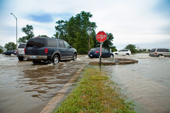
In January, Lycoming County and the borough of Muncy initiated the Blue Ribbon Project to increase public awareness of flood risk. Blue “Flood" signs were installed around the borough to mark the flood depth in a 1%-annual-chance flood. The aluminum signs were placed in popular areas around the borough located within the floodplain. For example, in Muncy’s North Market Street area, the signs show that floodwaters during a 1%-annual-chance flood could rise to ankle-depth in some places, and up to 16 feet in others. The project’s goal is to educate residents that flood risk is more than lines on a map.
“Most [residents] were shocked at how high the levels were actually around town,” said Jenny Picciano, Community Development/Lead Planner of Lycoming County.
The Blue Ribbon Project is part of the Greater Muncy Resilience Plan, a collaborative effort between the borough of Muncy, the township of Muncy Creek and Lycoming County. The plan aims to help residents and business owners better understand their flood risk, and to increase community resiliency.
More blue “Flood” signs may go up in other municipalities around the county. “The codes agency contact for the borough said he frequently uses the signs as a reference point for people who want to do work in the floodplain. A lot of people just aren’t aware,” said Picciano.
This project is one of many in the Greater Muncy Resilience Plan to raise flood risk awareness.
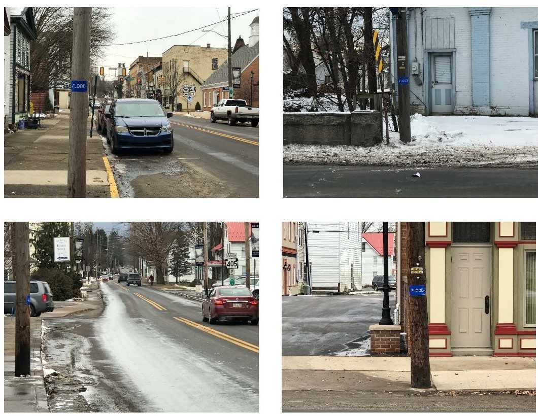 Source: Blue Ribbon Project, Muncy Borough (January 2020)
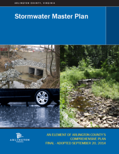
In growing communities like Arlington County, Virginia, aging stormwater systems are failing to keep pace with higher rates of stormwater runoff caused by denser development and more intense storms. This poses risks to people and habitats. Inadequate drainage can lead to more flooding in urban neighborhoods, and high flows of polluted stormwater can lead to poor water quality in urban streams. To mitigate the risks related to an outdated and undersized stormwater system, the Department of Environmental Services in Arlington County, Virginia launched a Stormwater Master Plan in 2014 and continues to highlight stormwater infrastructure upgrades as a key to flood resilience.
Arlington County’s stormwater system includes 10,000 storm drains, over 330 miles of storm sewers, and 33 miles of natural stream channels. When developed over 80 years ago, the system followed reasonable stormwater standards set for the time. Due to development patterns and more frequent intense rainstorms, however, the system has since become overwhelmed. Through the County’s multipronged flood mitigation approach, Arlington is assessing the best ways to handle stormwater challenges, focusing on resilience and adaptation, with a goal to manage emerging, dynamic changes while creating a flood resilient community.
The county’s strategy pairs public infrastructure investments with innovative outreach tactics to promote private mitigation actions. Public projects have included adding increased sewer pipe capacity in areas with a history of flooding, and building a “green street” project that introduced new canopy trees and rain gardens to collect runoff. Private incentive programs include the county’s StormwaterWise Landscapes program, which makes funding available for voluntary projects that will reduce stormwater runoff. Funding can be awarded for conservation landscapes, pavement removal, pervious surfaces, and rain gardens. Additionally, the county has formed an Inter-departmental Workgroup on Stormwater Management and Resilience that focuses on key topics such as emergency response, development and regulations, strategic improvements and policy changes, and communications and engagement.
As changing weather patterns lead to more intense storms, Arlington County is stepping up to the challenge. By implementing projects that increase the stormwater system capacity and educating residents about how to protect themselves and their property from future flooding, Arlington hopes to become a flood resilient community.
|
 Source: Getty Images
The Commonwealth of Virginia passed legislation in 2020 to create the Virginia Community Flood Preparedness Fund. This revolving loan fund will provide floodprone communities with low-interest loans and grants to carry out projects that help reduce flood damage and recovery costs. The fund will be administered by the Virginia Department of Conservation and Recreation.
According to the Pew Charitable Trust, the fund’s money will come from the state’s participation in the Regional Greenhouse Gas Initiative (RGGI), which places a fee on carbon pollution by utilities above a certain level, but allows them to purchase or trade allowances to offset their emissions. RGGI is expected to generate around $100 million annually for climate- and energy-related projects across Virginia, with 45% of that revenue (approximately $45 million) going to the Virginia Community Flood Preparedness Fund each year. The law states that at least 25% of the program’s funding must be used to help low-income communities that are at risk to flooding but lack the resources for mitigation and flood risk reduction.
The Virginia Community Flood Preparedness Fund will prioritize projects that use nature-based strategies for mitigating multiple properties or areas in one project. Nature-based strategies have proven successful in communities across the state and country, and include initiatives such as: buying out repeatedly flooded properties and converting them into parks and green space, installing living shorelines to lessen tidal surges and reduce erosion, and restoring streams and wetlands to more effectively absorb and take on stormwater.
Mitigation projects and initiatives funded by the Virginia Community Flood Preparedness Fund will also benefit communities by creating local jobs related to demolition, construction, debris removal and other mitigation activities.
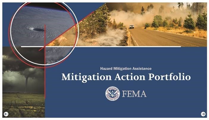 FEMA recently published the Hazard Mitigation Assistance (HMA) Mitigation Action Portfolio to share information on successful pre-disaster mitigation (PDM) projects and help communities win funding for their own projects.
In September, FEMA announced a new pre-disaster hazard mitigation grant program called Building Resilient Infrastructure and Communities (BRIC). The HMA Mitigation Action Portfolio not only introduces the BRIC program, it also highlights successful pre-disaster hazard mitigation projects from across the country. These case studies show the broad range of possible projects that can be funded. Each case study includes a summary and project details such as cost, primary and secondary benefits, partnerships, project timelines, challenges and resources. Mitigation topics include coastal and inland flooding, drought, wildfire and other natural hazards.
BRIC is part of the National Mitigation Investment Strategy, which is FEMA’s national strategy for increasing mitigation investment to reduce risks from natural hazards. Replacing the existing PDM program, BRIC is intended to invest in projects that use innovative partnerships to produce multiple resiliency benefits.
FEMA hopes the portfolio will inspire applicants to consider additional benefits beyond protecting life and property from disasters and think boldly when it comes to building resilient communities. More information about the FY20 BRIC program can be accessed at Grants.gov or here on fema.gov. Applications are due on January 29, 2021, but please note that this deadline is for state applicants to submit to FEMA. Subapplicants should check with their state leadership about earlier application deadlines. Reach out to your state leadership or State Hazard Mitigation Officer (SHMO) for more information.
 Prospective homebuyers and renters can now find information on a property’s flood risk when they search through Realtor.com. This year, the real estate website became the first in the nation to provide information about a property’s potential flood risk, as well as how that risk can change over time.
Realtor.com recognizes that a home is often a family’s biggest asset, and is providing flood risk information to help homeowners protect their investments. The website provides two flood risk ratings – the flood zone designation shown on FEMA’s flood maps, and the Flood Factor determined by the nonprofit First Street Foundation. The website also lists actions that buyers, owners and sellers can take to prepare for flooding and protect their homes.
The flood risk information on Realtor.com is an asset not only to homeowners, homebuyers and home sellers, but to real estate professionals as well. By helping people learn about the potential for flooding as they start the process of buying or selling their home, real estate professionals can build trust and confidence with their clients.
 Source: Getty Images
Randolph County, West Virginia, is the latest county to participate in the Severe Storm Cleanup program, which hires out-of-work individuals to clear blockages and debris from recent floods that could cause more flooding in the future. The program is offered by the Human Resource Development Foundation (HRDF), which works to empower diverse populations to achieve independence through training, education and employment. One of the largest nonprofit organizations in West Virginia, HRDF continually develops new and innovative approaches to assist out-of-work individuals through both federally and state funded programs, as well as through collaborative efforts with other agencies, organizations and private sector businesses.
HRDF’s Severe Storm Cleanup program, which is based out of the city of Morgantown, has been cleaning up damage caused by flooding throughout West Virginia for the past six years. The program is self-sufficient and is offered at no cost to counties. The workers employed through the program clear blockages from tributaries to help increase flow capacity, which lowers the chance of severe flooding in the future. The clean-up work in Randolph County will focus on the town of Harman, which experienced destructive flash flooding in June 2019. Clearing debris caused by past flooding could help decrease the chance of road closures, washed out bridges and severe property damage throughout the town and surrounding areas during the next heavy rainfall event.
FEMA Region 3 is hosting a webinar series for hazard mitigation planners and other partners interested in reducing risk in their communities. These “Coffee Breaks” are hour-long webinar sessions hosted every other month to provide mitigation best practices and highlight the work happening at federal, regional, state, and community levels to reduce risk across the region.
The Coffee Breaks are open to everyone involved in hazard mitigation, resiliency, or risk reduction planning in the public and private sectors, which includes community planners, emergency managers, floodplain managers, GIS technicians, government officials, contractors, and anyone else involved in the development and implementation of hazard mitigation and risk reduction strategies.
Please note: Webinar log in/call in information will be sent out several days prior to the date of the Coffee Break.
|
Exploring FEMA's Hazard Mitigation Planning Guidance and Resources
January 13, 2021 from 11AM ET - 12PM ET
From planning guidance to resource toolkits, FEMA Region 3 has a vast array of materials available to help you mitigate hazards in your community. However, with so much available, it can be challenging to identify when and how to leverage each resource during the hazard mitigation planning process. This webinar will explore federal guidance and resources available to help communities prepare or update a Hazard Mitigation Plan.
Connecting Climate Change to Hazard Mitigation Planning
March 17, 2021 11AM ET - 12PM ET
Communities throughout FEMA Region 3 are no stranger to the increasing frequency and severity of natural disasters caused by climate change. Intense storms, heat waves, and extreme flooding all significantly challenge our communities and result in cascading impacts that we need to better prepare for. This webinar will explore where to get data on climate change and how to effectively support mitigation through incorporating this data into hazard mitigation planning efforts.
Exploring Approaches to Plan Integration
May 19, 2021 11AM ET - 12PM ET
Plan Integration can be an overwhelming challenge: What tier of plans should I address: local, county, or planning district? How many of those plans within that tier should I review? What connecting questions should I ask about these plans? Are there any resources to assist me in this process? Please join us for our May Coffee Break to dive into these questions about plan integration approaches, as well as potential resources to assist you in this endeavor.
Identifying Technical Assistance Opportunities and Resources
July 14, 2021 11AM ET - 12PM ET
FEMA Region 3 and State Partners both provide a diverse array of technical assistance and training opportunities to support local hazard mitigation planning. This webinar will provide an overview of some of these federal and state training opportunities, as well as how to develop and deliver a local workshop in your community.
Understanding Mitigation: Preparing for a Zombie Apocalypse
September 29, 2021 11AM ET - 12PM ET
Mitigation and Mitigation Planning can be a challenging concept for the general public to understand. In this coffee break, we will show how the latest Guide to Expanding Mitigation uses a zombie invasion to make mitigation easy to understand, accessible and fun. See how common mitigation actions such as zoning ordinances and fortifications can be applied to pop culture references and other natural hazards for better engagement across audiences.
Assessing Substantial Damage through your Hazard Mitigation Plan
November 3, 2021 11AM ET - 12PM ET
For communities that participate in the National Flood Insurance Program (NFIP), substantial damage determinations are required by local floodplain management ordinances. Substantial damage applies to a structure in a Special Flood Hazard Area (SFHA) for which the total cost of post-disaster repairs is 50 percent or more of the structure’s pre-disaster market value. This webinar will explain the importance of assessing your community’s substantial damage process in your Hazard Mitigation Plan.
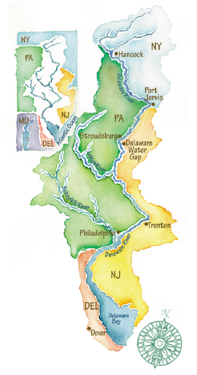
The Delaware River Basin Commission (DRBC) is a unique federal-interstate agency charged with overseeing a coordinated approach to water resources management in the watershed draining to the Delaware River and Delaware Bay. More than eight million people call this watershed home, and more than 13 million rely on its waters for their everyday needs. The DRBC brings together commissioners from New York, Pennsylvania, New Jersey, Delaware and the U.S. Army Corps of Engineers to cooperatively manage and improve these waters. Program areas include water quality protection, water supply allocation, regulatory review (permitting), water conservation, watershed planning, drought management, flood loss reduction, and recreation.
In late 2019, the DRBC created a new advisory committee to evaluate the threats posed by a changing climate and recommend coordinated measures to adapt to these threats. The Advisory Committee on Climate Change (ACCC) is tasked with providing scientifically based information to assess climate change vulnerabilities in the Delaware River Basin and to identify measures for mitigation, adaptation and resiliency. Vulnerabilities may include changes in the salt front in the tidal Delaware River (which could bring saltier waters to major water supply intakes), changes in the frequency and severity of flooding and droughts, and changes in habitat quality.
This year, DRBC selected 18 climate experts from its member states representing government, academia, business, scientists and watershed groups. The inaugural meeting of the ACCC took place in August and focused on reviewing the commission’s previous and ongoing projects related to climate conditions. The interdisciplinary members of the advisory committee will provide valuable climate and water resources insight as DRBC pursues an interstate approach to planning for changing future conditions.
|
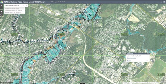 Source: FEMA's National Flood Hazard Layer
With Lackawanna County’s newly published flood maps, FEMA Region 3 became the first region in the country with “wall-to-wall coverage” of digital flood maps.
The transition to digital flood hazard maps is the latest step in a long history of flood risk mapping by the federal government. The United States Geological Survey (USGS) first started publishing flood inundation maps in 1959. The Department of Housing and Urban Development’s Flood Insurance Administration was then tasked with producing countywide Flood Insurance Rate Maps (FIRMs) in 1973, and FEMA became responsible for producing FIRMs in 1979. In 2003, after years of strategic planning, FEMA began moving forward with its Flood Map Modernization program. The digital maps produced by this initiative are more accurate than paper maps and are easier to use and maintain. Since 2009, FEMA has expanded its focus to address the full cycle of risk communication with its Risk Mapping, Assessment and Planning (Risk MAP) program. Currently, digital flood data covers over 90% of the U.S. population and is easily searchable via the National Flood Hazard Layer. Using this data, communities can prioritize mitigation actions and property owners can take steps to protect their homes and businesses.
The new Lackawanna County FIRM replaced paper flood maps made with data dating back to the 1970s. Up-to-date maps are critical to building resiliency to flood risk in Lackawanna County, which has a long history of flooding that includes severe damage from hurricanes Diane, Agnes and Gloria, and over 20 flood-related presidential disaster declarations.
MaryAnn Tierney, FEMA Region 3 Regional Administrator, emphasized the importance of using the newly complete digital information: “While we are proud to be the first FEMA region with digital flood maps for all of our communities, the most important thing is that we use this information to make our communities safer,” said Ms. Tierney. “The value in having digital flood maps is that it makes vital information easily accessible to everyone. Residents, local officials and state emergency managers can use these flood maps to make critical decisions that protect their communities and families.”

In this issue of the Resilience Report, we virtually connected with Jim Pappas, P.E., Deputy Director of Operations and Support for the Transportation Solutions Division at the Delaware Department of Transportation (DelDOT). Jim is an engineer by trade with a passion for resiliency and sustainability. After working with DelDOT’s materials lab, Jim saw firsthand all of the recycled materials being used in new roads and bridges. This encouraged Jim to get his MBA in Environmental Sustainability, leading him to his current role in sustainability efforts for the Department, which he started 10 years ago. As the division liaison between resiliency and transportation, Jim uses his almost 29 years of experience with DelDOT to make connections between effective transportation solutions, a changing climate and rising sea levels that threaten the almost 30 miles of Delaware coastline as well as communities further inland. Read on for an update on what Jim and his team have been up to.
|
Q: Can you tell us more about the work you do to help maintain roads and bridges using nature-based solutions to reduce erosion and flood hazards?
Our team works to find a balance between gray infrastructure and green infrastructure. For example, we built a new bridge at the Indian River Inlet along the Atlantic Ocean. We obviously used gray infrastructure to construct the bridge (steel and concrete), but we also worked with the Department of Natural Resources and Environmental Control (DNREC) to have them plant native grasses in the dunes near the bridge to prevent future erosion. This bridge has been in service for four to five years and from what we can tell, this nature-based solution has been highly effective.
Q: Can you provide more information on DelDOT’s Strategic Implementation Plan for Climate Change, Sustainability and Resilience for Transportation?
Jim: This plan was developed due to an Executive Order signed by Governor Jack Markell in 2013. The order created a Governor’s Committee on Climate and Resiliency, which worked to develop an implementation plan to continue Delaware’s reduction of greenhouse gas emissions and to improve the state’s long-term resilience to flooding and sea level rise. In addition, the order directed all state agencies to incorporate climate adaptation measures in the siting and design of state-funded projects. The committee produced a Climate Framework Report. This report identified more than 150 actionable recommendations that should be implemented by various agencies throughout the state. Nineteen of those recommendations were assigned to DelDOT.
This is how DelDOT’s Strategic Implementation Plan for Climate Change, Sustainability and Resilience for Transportation came about. Many of these recommendations seek to incorporate climate change into DelDOT’s asset management. By improving its asset management practices, through the incorporation of climate resiliency into planning, design, materials usage, maintenance and siting guidelines for transportation infrastructure, DelDOT enhances the state’s ability to better manage adverse climate change impacts associated with the transportation network.
DelDOT worked internally across its own agency – with Transportation Solutions, Planning, and Maintenance & Operations – to collaborate on ways to incorporate climate adaptation into our operation manuals, design manuals and planning documents. For example, at the time this Executive Order came out, we were already updating our bridge design manual so we added language where if you started working for DelDOT Design Group today, would explain how to design a bridge with special considerations for climate change.
This is a living and breathing document with short, medium and long-term goals. Some goals are things that are taking place now, while others will take more time, but across the board all state agencies are implementing projects and programs with this Executive Order in mind. We realized the issues around climate change and the seriousness of these concerns to our communities. Here in Delaware, we have perfectly sunny days where roads will flood twice a day because of the high-tide cycle. People that have worked for the department for over 20 years are saying they haven’t seen certain roads flood in all of their years – but now are. These are problems we know we need to address, and the Strategic Implementation Plan can help us do that.
Q: Can you tell us about how funding is secured to support these projects you are implementing?
Jim: We don’t have a line item in our budget for resiliency or sustainability. Instead, we factor this into our design and operations manuals. If we need to elevate or widen a road to withstand storm events, those design elements are now factored in as project costs.
We have also applied for different types of federal and state grants. We have applied for and been awarded FEMA planning grants, and DNREC has had some funding available over the last couple of years. Transportation, for good or bad, touches everyone’s life. We are able to come to the table with some ideas, which ultimately helps in getting awarded grant funding.
Q: Do you work with other agencies or organizations on these projects?
Jim: The beauty of working for a small state is having the opportunity to work so closely with other state agencies. We work closely with DNREC, which has a Climate, Coastal, and Energy Division. We work closely with them, in part, because of the data they are gathering and the models they are running. When we are designing a bridge or road, we are hoping it is going to last 50 or 100 years. By using models produced by DNREC, we can better project 50 years out, so we need to know the best areas to build in to avoid flooding or what elevation should be designed.
Our work with the Federal Highway Administration and DNREC is an ongoing partnership. Inevitably, our roadways line right up against the dunes, which is backed by the ocean. In the past, in one particular coastal area when storms come through, we have seen so much sand on the roads from sand dunes that we’ve had to use snowplows to remove the sand. By working together and addressing problems with solutions that aren’t stepping over one another, we can have significant results.
We also work with other regional and local groups. For example, DelDOT is part of the Transportation and Climate Initiative (TCI). TCI is a regional collaboration of 12 Northeast and Mid-Atlantic states and the District of Columbia that seeks to improve transportation, develop the clean energy economy and reduce carbon emissions from the transportation sector.
Q: Are you working on any other flood risk management projects to increase resiliency?
Jim: We act as kind of a resiliency liaison with other divisions. For example, the Bridge Design Group recently came to us regarding the Route 9 Corridor, which hugs the coast on the east side of the state. There are a couple of bridges coming up on their regular rehabilitation cycle. They came to us wanting to know if these can be addressed as simple, standard repairs or whether they are facing any issues like needing to raise the bridge. We will work with them to determine any research that is needed in terms of flood modeling and storm surge modeling to make a more educated and forward-thinking decision; this will determine how much money should be allocated toward solving this issue.
Additionally, we’re working on a particular roadway that goes to a small beach community, which floods twice a day at times. This community only has one road in and one road out. We are working with that community to make a determination of how best to address this issue. The community wants us to just raise the road with conventional materials and design approaches, but that might not be a cost-effective solution, so we’re looking at other options to ensure it is the most economic and sustainable solution.
Q: Anything else you’d like to share about the work DelDOT is doing towards making communities more resilient?
Jim: In conclusion, we have really good connections and relationships both within and outside of DelDOT. We work with many key stakeholders that are passionate to be doing this work. For example, we work with the Resilient and Sustainable Communities League (RASCL) [see our Summer Issue Spotlight for more information on RASCL]. RASCL is a collaborative group with various nonprofit and state agencies that work together to support smaller communities. DelDOT does a lot of bigger projects, so we don’t always have a ton of opportunities to work with smaller communities. My initiation project with the RASCL group was working with a small beach community to install sensors in the river that are hooked up to a variable message sign to let drivers know about road closures when the water gets to a certain elevation. This project cost a minimal amount of money but was extremely effective in pushing messaging out to the community about safety. After seeing the success and impact of this project, we definitely want to work with them on future projects to help our communities increase their resiliency.
|