|
With a remarkable amount of pre-disaster mitigation funding on the horizon resulting from the Building Resilient Infrastructure and Communities (BRIC) grant program, FEMA Region III partnered with both the Delaware Emergency Management Agency (DEMA) and Maryland Emergency Management Agency (MEMA) to successfully deliver a Plan Implementation and Grant Development Workshop in each state. Both day-and-a-half long workshops served as opportunities to discuss how communities assess risk, take action on projects identified in local Hazard Mitigation Plans to reduce future risk, and develop robust grant applications to mitigate risk. During these hands-on workshops, participants were also able to:
- Identify ways to make the community’s Hazard Mitigation Plan actionable and implementable;
- Learn how to utilize FEMA’s tools for mapping risk;
- Explore grant eligibility requirements and Scope of Work (SOW) best practices;
- Define roles and responsibilities among various stakeholders in the plan implementation and grants development process; and
- Work to identify new and existing funding opportunities that address community needs.
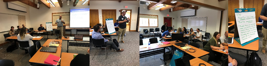 Most notably, workshop participants returned to their communities with a SOW ready for inclusion in a Hazard Mitigation Assistance (HMA) mitigation project grant application. The success of both the Delaware and Maryland workshops, as evidenced by their turnout, considerable engagement, positive workshop evaluations, and the development of actionable project SOWs, has spurred FEMA Region III and its state partners to deliver additional installments of this event. Another successful Plan Implementation and Grant Development Workshop was held in Hampton Roads, Virginia in Summer 2018, and FEMA plans to deliver similar workshops in Washington, DC, West Virginia, and Pennsylvania in 2020.
FEMA Region III continues to host a webinar series for hazard mitigation planners and other partners interested in reducing risk in their communities. These “Coffee Breaks” are hour-long webinar sessions hosted every other month to provide mitigation best practices and highlight the work happening at federal, regional, state, and community levels to reduce risk across the region.
The Coffee Breaks are open to everyone involved in hazard mitigation, resiliency, or risk reduction planning in the public and private sectors, which includes community planners, emergency managers, floodplain managers, GIS technicians, government officials, contractors, and anyone else involved in the development and implementation of hazard mitigation and risk reduction strategies.
Please see below for descriptions of the upcoming 2020 Coffee Breaks.
Annual Hazard Mitigation Plan Reviews (Options and Outcomes) - March 18, 2020
Annual Hazard Mitigation Plan reviews are a valuable tool to track progress, identify new risks, and keep the momentum going on future planning efforts. If done correctly, an annual review can also mean a much easier lift for the next plan update! During this Coffee Break webinar, we will discuss how several plan developers organize annual reviews and what can be accomplished.
Building a Better Scope of Work for Your Hazard Mitigation Plan - May 20, 2020
Planning for your next Hazard Mitigation Plan update? Why not engage your State and FEMA on the expectations you’d like to set well before ever starting your planning process. There are many opportunities to improve current plans based on previous plan reviews, newly created tools, as well as perspectives on participant engagement during development of the risk assessment and mitigation strategies. Please join us for an in-depth conversation on building out your strategy for your next plan; including timing, scheduling, content and approach.
Addressing the Risks of High Hazard Potential Dams (HHPD) - July 15, 2020
Did you know that the average age of dams throughout the United States is well beyond the anticipated 50-year lifespan? In several states across Region III, the average age is over 70 years. Aging dam infrastructure is becoming a national concern as High Hazard Potential Dam (HHPD) failures put Americans at risk, result in infrastructure damage, and can have substantial negative economic and environmental impacts. In order to prevent future catastrophic events due to dam failure, it is important for both the state and local government to understand the risk of the 1,739 HHPDs that span across FEMA Region III. This webinar will explore how the risk of dam failure can be effectively assessed and addressed through state and local Hazard Mitigation Plans, FEMA’s HHPD grant program, and emergency action plans.
Tracking Risk Reduction through Your Capabilities Assessment - September 16, 2020
An important, but often overlooked component of any hazard mitigation plan is the capabilities assessment. The capabilities assessment helps a community understand how effective a mitigation program is and if risk is being reduced within the community. The capabilities assessment is not meant to be a simple list of laws, regulations, policies, and programs that exist at the federal, state, and local level. The assessment should analyze effectiveness, challenges, and issues to implementing and maintaining a hazard mitigation program. We will explore various data sources, metrics, and methodologies for analyzing your communities’ capabilities. Your community should strive to answer the question “So What?” when it comes to having a land use plan, having an updated building code, and having funding opportunities available or not.
Bringing Lifelines into Hazard Mitigation Planning - November 25, 2020
Energy, Water, and Transportation: These are just some examples of “lifelines,” which FEMA defines as anything that enables the continuous operation of government functions and critical business. What lifelines in your community are essential to human health, safety, and economic security? Are you aware of any lifelines that exist in at-risk areas based on risk modeling? This Coffee Break will explore how lifelines can be assessed as whole systems and incorporated into your Hazard Mitigation Plan through risk assessment modeling and mitigation action development which can help to improve and invest in the lifelines in your community.
Register for the webinars here.
|
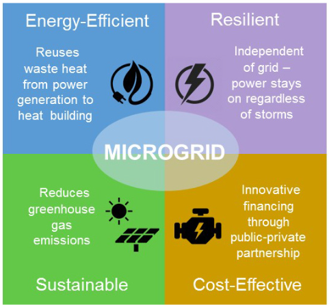
Montgomery County, Maryland seeks to improve the resilience of critical facilities by using newly installed microgrids. A microgrid is a localized group of electricity sources and loads that can be disconnected from the power grid and function on its own. This enables facilities to operate independently from the grid to enhance crucial service delivery to the community when electricity sources are threatened. The microgrids in Montgomery County work as a local power system using clean and renewable energy sources to provide electricity, heat, and cooling to facilities on an ongoing basis. These advanced microgrids are smart solutions for improving the resiliency of public facilities while also reducing environmental impacts and long-term operational costs to the community.
This initiative was ignited by major storms that caused several large-scale and extended power outages in the county. Montgomery County has installed microgrids at the Public Safety Headquarters (PSHQ) and the Montgomery County Correctional Facility (MCCF). The county decided to first focus on facilities providing key public safety and disaster response services. PSHQ houses central County Police and County Fire and Rescue Services as well as the Office of Emergency Management. The first microgrids at PSHQ and MCCF started their life cycle in summer 2018.
Montgomery County aims to reduce its greenhouse gas emissions by 80 percent by 2027, and by 100 percent by 2035. Estimates show that the new system will meet most of the facility’s energy needs and reduce greenhouse gas emissions by over 6,800 metric tons annually. Clean energy incorporation using microgrids is one way the county plans to meet these goals. The installed microgrids include canopy-mounted solar panels which provide shade for cars and power for the facilities. This canopy also supports electric vehicle charging for the county’s fleet and its employees and visitors. The system also includes a new Combined Heat and Power system and absorption chiller, which provide heating and cooling.
This project was made possible through public-private partnerships in the county. Private partners included Duke Energy Renewables and Schneider Electric in areas where the two companies own and operate existing electrical systems. Montgomery County also garnered additional support from the state. The County is currently evaluating options to upscale microgrids to a campus or community scale, and to downscale for other facilities that provide key services to the community. County officials are hopeful that microgrids can also be used as an opportunity to spur economic development and other positive social outcomes. To learn more about microgrids in Montgomery County, please visit their website here.
|
The City of Newport News, Virginia created a Flood Assistance Program in 2015 to help mitigate high-risk flood concerns in the community. The Flood Assistance Program, which could serve as a model for other communities, enables the acquisition, relocation, or elevation of structures located in the floodplain based on their risk of flooding. To be eligible for the Flood Assistance Program, a Newport News home must be located in the 100-year floodplain, have a finished floor elevation below the 100-year flood level, and have been under construction before December 31, 1974.
Funding for the voluntary program is allocated from the city’s Stormwater Management Fund and is often a combination of local and Federal funds. Federal funding for the program primarily comes from FEMA’s Hazard Mitigation Grant Program (HMGP) but also includes funds from a variety of other Federal programs and sources. Funding for the Flood Assistance Program has increased in recent years from $200,000 annually to approximately $750,000 annually.
The Flood Assistance Program has successfully mitigated the flood risk of approximately two structures per year for the last several years, primarily through acquisition. The program was directly linked to a mitigation action in the 2017 Hampton Roads Hazard Mitigation Plan and is viewed as a key mitigation tool in the region. The City of Newport News plans to continue growing the Flood Assistance Program to further mitigate flood risk to the community’s most vulnerable properties. To learn more about the program, visit the Flood Assistance Program on the City of Newport News’ website.
|
In May 2019, Philadelphia Parks and Recreation, with the support of the Fairmount Park Conservancy, unveiled a new Master Plan for Franklin Delano Roosevelt (FDR) Park in South Philadelphia. The new Master Plan aimed to create a sustainable vision for the park, with a key focus on resiliency.
FDR Park was created in 1914 on the low-lying marshes of South Philadelphia between the Delaware and Schuylkill Rivers. Along with being in the floodplain, the park faces several challenges that contribute to its repetitive flooding issues, such as aging water and stormwater infrastructure, as well as a faulty tide gate that causes drainage problems.
 The planning process involved public engagement and a robust study of the site’s hydrology to develop an understanding of how stormwater moves onto the site and what portions of the park are most at risk. The FDR Park Master Plan presents a recommendation to split the park into “wet” and “dry” zones. The “wet” zones can be defined as natural wetlands and marshes that will retain excess water and slow the spread of floodwaters, whereas the “dry zones” are intentionally located outside or near the edges of the floodplain to reduce the likelihood of flooding. The outcome of this strategy was the identification of five key action items:
- Expand the ecological core
- Repurpose the urban edge
- Construct a new elevated maintenance building
- Catch stormwater runoff
- Replace the tide gate
The goal of these five actions is to reduce the flood risk in FDR Park while increasing the park’s safety and resiliency. Moving the park’s assets into the newly designated “dry” zones will play a large part in this initiative. Adding green stormwater infrastructure and fixing the tide gate will support the ecological role of the park’s lakes, wetlands, and marshes in mitigating flood risk. As the project attracts funding, stay tuned for updates on the implementation of the FDR Park Master Plan in future issues of the Resilience Report.

In September 2019, the West Virginia Association of Realtors held their annual conference in Wheeling, West Virginia. The organizers of the 2019 conference invited the Federal Emergency Management Agency (FEMA) to attend and present on flood insurance and its impacts on the real estate market.
FEMA’s session at the conference kicked off with a presentation from Dave Weaver, the Planning Officer and GIS Coordinator for the Wheeling-Ohio County Homeland Security and Emergency Management Agency. In his presentation, Mr. Weaver discussed local flood risk and floodplain management in the Wheeling, West Virginia region.
Following the presentation, Mr. Weaver was joined by Rich Sobota, FEMA Region III Insurance Specialist, and Doug Clatterback, representing the West Virginia Association of Realtors, for a conversation about flood insurance and its relationship to the real estate industry. The discussion focused on the National Flood Insurance Program (NFIP), flood insurance rates and regulations, trainings, and other resources.
Many conference attendees expressed interest in additional training and education opportunities and resources related to flood insurance and the NFIP. With approximately 200 people in attendance at the conference, the event was a great success and a unique opportunity for FEMA to have a candid conversation with key stakeholders of flood insurance and the NFIP.
|
 |
|
The Commonwealth of Virginia is taking new steps to address changing weather conditions. The state recently launched the country’s strongest flood protections for state-owned property, which is the first of its kind for any state. On November 15, 2019, Virginia Governor Ralph S. Northam signed Executive Order Number 45 into action, which created the Virginia Flood Risk Management Standard to improve flood protection across the state, requiring smart and resilient construction of state buildings. Flooding is the most common and costly disaster in Virginia. There is statewide risk due to thousands of miles of streams, rivers, and estuarine and coastal shoreline. |
Executive Order 45 created new requirements for state-owned properties. All development on state-owned property must comply with locally adopted floodplain ordinances and any flood-related standards identified in the Virginia Uniform Statewide Building Code. The order also established increased freeboard standards in riverine and coastal inundation areas affected by sea level rise. These incorporate the National Oceanic and Atmospheric Administration’s (NOAA) Intermediate-High Scenario curve as the new state standard to predict sea level rise. Under the updated standards, state-owned buildings must be built to certain elevations to protect them from flood risk. Based on the NOAA curve, that is nearly a 4-foot sea level rise by 2070. An extra foot is added to freeboard standards to account for high tide. Additionally, all building scoping, designing, siting, and construction must use a 50-year mid-life estimate for building longevity. To allow for future adaptation, any new state-owned buildings constructed in flood-prone areas shall be built using adaptive designs below the lowest floor. State-owned property in communities not participating in the NFIP must still comply with NFIP requirements. No new state-owned buildings on state-owned property can be constructed, reconstructed, purchased, or acquired by the Commonwealth within certain parts of the floodplain, unless granted a variance by the Director of the Department of General Services. This continues an existing ban against developing state-owned buildings in flood-prone areas without a variance. Even with variances, all new state-owned buildings must be built to the new height standards. In particular, the state looks to protect sea level rise inundation areas in addition to the flood hazard areas that are currently mapped by FEMA.
These standards apply to all new state-owned buildings receiving funding authorization on or after January 1, 2021. Additional studies and updates to these standards are at the discretion of the Chief Resilience Officer. By October 1, 2020, the Department of Conservation and Recreation will produce a guidance document to provide agencies the methodology for complying with freeboard and sea level rise planning standards. Additionally, the Chief Resilience Officer will convene a work group with the secretaries of state agencies to establish state-level, NFIP-compliant requirements for all development activity on state-owned property within flood-prone areas. These include a process to enforce new building standards and a process to document and maintain records or any variance or development. Please review this press release for more information.
In Southwestern Pennsylvania, the Water Resource Center (WRC), a division of the Southwestern Pennsylvania Commission (SPC), promotes regional collaboration on water-related topics, facilitates education and outreach to communities, and provides technical assistance to its member governments. In this edition of the Spotlight, we interviewed Erin Kepple-Adams, Water Resource Manager at the Water Resource Center. Erin, and her co-worker Claire Jordy, comprise a team of two that works diligently across 10 counties and 548 municipalities to provide communities with the resources they need to help them become more resilient. Erin spoke with us about the ways WRC is addressing stormwater management, wastewater, the National Flood Insurance Program (NFIP), and the Community Rating System (CRS) within their corner of the Commonwealth.
Q: What is the goal of the Southwestern Pennsylvania Commission’s Water Resource Center and how was it created?
Water resource management is a large and growing field in our region with continuous emerging concerns. Southwestern Pennsylvania has an abundance of water quantity but degraded water quality from many sources, as identified by the Pennsylvania Department of Environmental Protection. Due to a mounting need for regional water resource planning, the SPC formed the WRC in 2013. The WRC works to provide technical assistance and educational resources, to serve as a regional information clearinghouse, and to provide a forum for regional coordination on water issues.
Q: When WRC started in 2013, stormwater management was the primary focus. Is this still the case?
WRC has primarily focused on stormwater management issues over the last few years for many reasons, one of which includes an understanding that properly managed stormwater can possibly help decrease the severity of flooding in urban areas. We’ve been providing opportunities for communities to learn more about resiliency topics like available grant funding to support hazard mitigation, the ins-and-outs of the NFIP and CRS programs, ways to become more resilient, and insurance implications for homes both in and out of the regulated floodplain.
We’ve found a need to undertake more strategic educational outreach, such as explaining federal programs to municipalities. Some communities may not be aware of who their floodplain administrator is, while others simply don’t have the resources to figure out all the nuances of floodplain mapping. Municipal staff provide information directly to their community members, and it is important that they have educational resources made available to them at no cost. This is why we’ve worked to develop regional educational materials that can be accessed via our website and through printed and electronic versions of educational fact sheets on topics such as the NFIP, CRS, and funding sources for mitigation and disaster recovery.
We are hoping that by focusing on education, we can help communities make the best proactive decisions about investing in water management and resiliency. For example, the CRS program can be a hard sell. Some communities struggle to justify spending tax dollars on a staff person to get the program up and running, but WRC is trying to educate communities that the CRS is an investment in the longevity of the entire community.
Q: Can you tell us about some of the initiatives and technical support WRC provides to communities?
We have been developing and distributing educational materials, identifying needs for regional educational initiatives, and offering educational workshops to help our communities with various flood resiliency topics. Through these workshops, we’ve partnered with various federal, state, regional, and local organizations.
Since 2014, we’ve held 22 flood and resiliency-related workshops. These workshops have brought in experts to present on topics such as flood resiliency, holistic floodplain management, duties of a floodplain administrator, the NFIP, CRS, elevation certificates, hazard mitigation grants, grant writing, and Substantial Damage/Substantial Improvement.
Q: Are you working on any flood risk management projects to increase resiliency?
Yes, in 2016 we completed a one-year joint project with the US Army Corps of Engineers called the Municipal Infrastructure Inventory Pilot Project. It was funded through the Planning Assistance to States (PAS) program. Pilot communities included Elizabeth Township in Allegheny County and Burrell Township in Indiana County. The project identified and prioritized areas for future flood response and infrastructure management through a GIS inventory, field survey, and an analysis of municipal stormwater infrastructure (culverts, small bridges, etc.). Under-sized or otherwise insufficient crossings for future rainfall events were also identified.
In 2018, we received two Keystone Community Grants from the Pennsylvania Department of Community and Economic Development (DCED) for a two-phase pilot project targeted at Appalachian communities managing flood risk. Phase I consisted of collecting data, identifying a pilot community dealing with flood regulation changes (Ford City), meeting with community leaders, surveying residents and businesses in the floodplain, holding an educational public meeting, and finally asking volunteers to serve on a working group. Phase II consisted of conducting community working group meetings, identifying issues, developing goals, and making recommendations based on data collected to a newly formed task force.
Q: What kind of collaboration have you seen with other agencies or within your own agency?
WRC has great partnerships and has collaborated with the US Army Corps of Engineers, FEMA, PEMA and DCED on various educational efforts in the southwest Pennsylvania region. We have also helped support events for the Pennsylvania Association of Floodplain Managers.
The WRC also provides support to all our departments within SPC on various initiatives. SPC recently adopted the Long Range Transportation Plan: Smart Moves for a Changing Region that includes a sustainability strategy and a clean water strategy. These strategies will help communities adapt to and decelerate the impacts of climate change and promote sustainable regional water resource management.
Q: Anything else you’d like to share about WRC?
We encourage feedback on the needs that exist in your communities, so please contact us at wrc@spcregion.org or 412-391-5590 to see if we can help.
Note: The interview above has been edited for length.
|
|