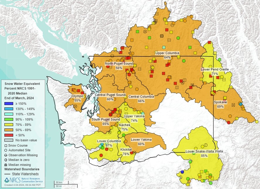
 Basin snowpack (% of median) as of April 1
Washington Water Supply Outlook Report for April now available
By Matt Warbritton
Supervisory Hydrologist Portland Data Collection Office
SPOKANE VALLEY, Wash. – The normal timing for peak snow accumulation has passed or is near for all major basins in Washington. Snow drought conditions, in some cases severe, persist across much of Washington, notably in the Puget Sound Basin, Olympic Peninsula, portions of the Lower Yakima, and across much of northern Washington and into the Idaho panhandle. Several snow courses and SNOTEL stations from the central Cascades and across northern Washington have record or near record low snow-pack as of April 1.
Drier conditions for these regions in March, with the exception for parts of the Upper Columbia, has exasperated deficits in water year-to-date precipitation at several stations, including for parts of the Lower Yakima. Poor conditions in these areas have led a below-normal water supply outlook for the late spring-early summer, with 50%-exceedance forecasts generally calling for below normal stream-flows as of April 1.
If drier conditions continue to prevail in these regions over the next few weeks, water resource managers may consider using the lower exceedance forecasts. WSFs generally reflect a winter that has trended close to the expected precipitation pattern based on past El Niños, with slight departures in some areas, such as wetter conditions in the southern Cascades in Washington. Continue reading the report here.
Visit the Washington Snow Survey & Water Supply Program web page here.
|