|
Below is the July 1 edition of the South Dakota Grassland Productivity Outlook map produced using data from the South Dakota Drought Tool. The map is also posted on the South Dakota Natural Resources Conservation Service (NRCS) Range and Pasture webpage (bit.ly/Range_Pasture). In July, we reach peak production, so the projected maps won’t be available again until November. The South Dakota Drought Tool utilizes a two-year weighted average of precipitation data to determine its percent of normal production calculation. The numbers are calibrated based on historical clipping data from across the state. This prediction only relates to grassland forage production (not so much cropland) and will not predict forage quality. Producers utilizing this map should consider local conditions when making decisions as the weather stations used to create the map are not equally spread out across each county of the state.
Conditions have definitely improved for western South Dakota. There are still some areas of “red” on the map. Some of that may be due to spotty rain events– we have been seeing that more and more. Another reason for excessive red in western South Dakota could be precipitation stations not accurately recording data. Some stations have 0 for months that typically receive some precipitation, so those numbers throw off the general calculations. Every few years, South Dakota Drought Tool developers comb through the weather stations to determine which ones are under-preforming, and remove them from the tool drop-down lists. This helps with accuracy of the tool. One way to make sure the Drought Tool works well for your operation is to collect your own precipitation data. You can enter the precipitation data manually within the tool and utilize the nearest weather stations for long term averages for calculation purposes.
For the rest of the state, there has been a lack of precipitation that has led to worsening conditions. In these areas, drought planning and grazing planning are key to ensuring that management doesn’t cause lasting effects on the grasslands. For tips and ideas on how to manage through a drought, consider attending one of the two remaining SD Grassland Coalition Grazing Schools: one in Marvin July 25-27, and one in Chamberlain/Oacoma September 12-14. Visit the event page for registration details: https://sdgrass.org/grazing-school/. The South Dakota Soil Health Coalition is also hosting their annual Soil Health School near Garretson, South Dakota. This is another great option for grazers and croppers alike! Visit the event page for more information: https://www.sdsoilhealthcoalition.org/event-calendar/soil-health-school/.
The following resources are also available*:
SD NRCS Range and Drought page: bit.ly/Range_Pasture
SDGC’s Drought Planning website: sddroughtplan.org/
National Drought Mitigation Center: drought.unl.edu/ranchplan/Monitor.aspx
National Integrated Drought Information System: drought.gov/
U.S. Drought Monitor: droughtmonitor.unl.edu
SDSU Extension Drought Resources: extension.sdstate.edu/drought
SD Growing Resilience Web page: www.growingresiliencesd.com
SD Grazing Exchange: www.sdgrazingexchange.com/
*If there are any issues with the links, you may have to type them manually into your web browser.
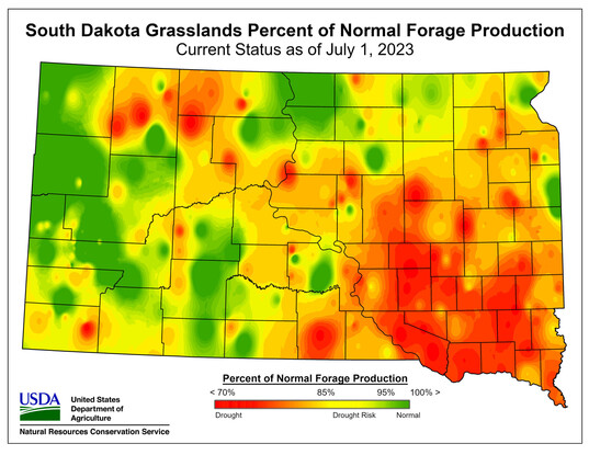 This map shows SD's current grassland production status.
|