USDA GovDelivery Newsletter

View as a webpage / Share

US Department of Agriculture

May 2022

Map Packets Ready to be Picked up for Spring Acreage Reporting

Planting

Map packets are ready to be picked up from the FSA office.  Operators will pick up map packets, fill out the maps at their leisure at home, and drop the completed packet back off to FSA.  FSA will load the maps and notify the producer when they are ready to sign.  We are offering two ways to sign the certifications.  You can have us send them through OneSpan our digital signing service to be signed without having to come to the office.  Or we can make an appointment and you can sign the loaded acreage reports with our staff.

-Did you plant corn?  The final plant date for corn is May 25th.  When you come to pick up you map packet, please bring your corn plant dates.  We will have you fill out that map so that is one less map you must take with you.  We may need to make appointments for this process.

-Please return maps with all the full season crops.  We must have all initial acres loaded and signed by July 15th.  Prodcuers must allow FSA time to load and time for you to sign by this date.

-Saline County is eligible for double crop, beans after wheat only.  If you double crop we would like to go ahead and get your full season or initial crop loaded and out of the way.  Same goes for subsequent crops (example Ottawa County beans after wheat).  Once you get the double or sub crop planted, if before July 15th get those to us by then.  OR if you plant double or sub crop after July 15th, you have 15 days after planting to report those.

-Please return all map packets by June 26th so staff can get everyone loaded by the deadline.  Final pant date for milo is June 25th.

-Each Operator will receive a 578 Summary Print to get to their crop insurance agent.  

-Failure to report all crops and sign the certification by July 15th, will result in a late file fee of $46 per farm and a spot check done by FSA.


Ottawa, Lincoln, Ellsworth, Mitchell, Rice...Eligible for a 4 month Livestock Forage Program drought payment

ALE

The US Drought monitor indicates Ottawa, Lincoln, Ellsworth, Mitchell, and Rice County have been in D3 drought for 4 weeks. This qualifies land located in those counties for a 4-month Livestock Forage Program drought payment.  Producers must apply for the program where the farm is administratively carried.   Saline County must be in D2 for 8 weeks before they will trigger (if conditions continue they wil trigger for a 3 month payment around June 16th)

FSA can take appointments with guys to get started on the process.  The first step will be to ensure grass is certified how you want it.  The 578 Summary sheet will be provided, it is your responsibility to make sure grass is reported and how you want it.  After July 15th the intended use can not be changed.  For example, if you sign the acreage report by July 15th and report it as forage but need to graze it, those acres will not be eligible for LFP.

NAT=Native Grass
SMO= Smooth Brome
LS= Left Standing
GZ=Graze
FG=Forage

FSA can provide CCC 855’s “Annual Lease Agreement Certification Statements” with tenants to have each of their landlords sign.  FSA can only accept a lease if it has a specific start and end date.  Typically, most leases are verbal so the landlord must agree to renting the grass and the terms on the CCC 855’s form.  Please note the CCC 855 forms must list the owners name exactly like it is listed in the FSA office.

After these steps are completed, we will schedule an appointment to fill out the application.  In the meantime, you will need to show proof of ownership of the cattle up to 60 days prior to the start of the eligible disaster date.  For Ottawa County you have to prove you owned the cattle no later than April 18th


Five Facts About the United States Drought Monitor

drought

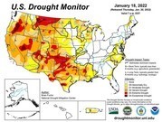
This is likely no surprise to you, but drought persists across the western U.S. and is intensifying in some areas. No geographic area is immune to the potential of drought at any given time. The U.S. Drought Monitor provides a weekly drought assessment, and it plays an important role in USDA programs that help farmers and ranchers recover from drought.

Fact #1 - Numerous agencies use the Drought Monitor to inform drought-related decisions.

The map identifies areas of drought and labels them by intensity on a weekly basis. It categorizes the entire country as being in one of six levels of drought. The first two, None and Abnormally Dry (D0), are not considered to be drought. The next four describe increasing levels of drought: Moderate (D1), Severe (D2), Extreme (D3) and Exceptional (D4).

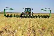
While many entities consult the Drought Monitor for drought information, drought declarations are made by federal, state and local agencies that may or may not use the Drought Monitor to inform their decisions. Some of the ways USDA uses it to determine a producer’s eligibility for certain drought assistance programs, like the Livestock Forage Disaster Program and Emergency Haying or Grazing on Conservation Reserve Program acres and to “fast-track” Secretarial drought disaster designations.

Fact #2 - U.S. Drought Monitor is made with more than precipitation data.

When you think about drought, you probably think about water, or the lack of it. Precipitation plays a major role in the creation of the Drought Monitor, but the map’s author considers numerous indicators, including drought impacts and local insight from over 450 expert observers around the country. Authors use several dozen indicators to assess drought, including precipitation, streamflow, reservoir levels, temperature and evaporative demand, soil moisture and vegetation health. Because the drought monitor depicts both short and long‐term drought conditions, the authors must look at data for multiple timeframes. The final map produced each week represents a summary of the story being told by all the pieces of data. To help tell that story, authors don’t just look at data. They converse over the course of the map-making week with experts across the country and draw information about drought impacts from media reports and private citizens

Fact #3 - A real person, using real data, updates the map. Each week’s map author, not a computer, processes and analyzes data to update the drought monitor. The map authors are trained climatologists or meteorologists from the National Drought Mitigation Center at the University of Nebraska-Lincoln (the academic partner and website host of the Drought Monitor), the National Oceanic and Atmospheric Administration and USDA. The author’s job is to do what a computer can’t – use their expertise to reconcile the sometimes-conflicting stories told by each stream of data into a single assessment.


Fact #4 - The Drought Monitor provides a current snapshot, not a forecast.

The Drought Monitor is a “snapshot” of conditions observed during the most recent week and builds off the previous week’s map. The map is released on Thursdays and depicts conditions based on data for the week that ended the preceding Tuesday. Rain that falls on the Wednesday just before the USDM’s release won’t be reflected until the next map is published. This provides a consistent, week‐to‐week product and gives the author a window to assess the data and come up with a final map.

Fact #5 – Your input can be part of the drought-monitoring process.

State climatologists and other trained observers in the drought monitoring network relay on-the-ground information from numerous sources to the US Drought monitor author each week. That can include information that you contribute.

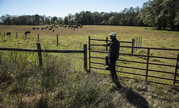
The Drought Monitor serves as a trigger for multiple forms of federal disaster relief for agricultural producers, and sometimes producers contact the author to suggest that drought conditions in their area are worse than what the latest drought monitor shows. When the author gets a call like that, it prompts them to look closely at all available data for that area, to see whether measurements of precipitation, temperature, soil moisture and other indicators corroborate producer-submitted reports. This is the process that authors follow whether they receive one report or one hundred reports, although reports from more points may help state officials and others know where to look for impacts.

There are multiple ways to contribute your observations: 1. Talk to your state climatologist - Find the current list at the American Association of State Climatologists website. 2. Email - Emails sent to droughtmonitor@unl.edu inform the USDM authors.

3. Become a CoCoRaHS observer - Submit drought reports along with daily precipitation observations to the Community Collaborative Rain, Hail & Snow Network. 4. Submit Condition Monitoring Observer Reports (CMOR) - go.unl.edu/CMOR.

For more information, read our Ask the Expert blog with a NDMC climatologist or visit farmers.gov/protection-recovery.


Reminders for FSA Direct and Guaranteed Borrowers with Real Estate Security

Farm Loan Programs

Farm loan borrowers who have pledged real estate as security for their Farm Service Agency (FSA) direct or guaranteed loans are responsible for maintaining loan collateral. Borrowers must obtain prior consent or approval from FSA or the guaranteed lender for any transaction that affects real estate security. These transactions include, but are not limited to:

· Leases of any kind

· Easements of any kind

· Subordinations

· Partial releases

· Sales

Failure to meet or follow the requirements in the loan agreement, promissory note, and other security instruments could lead to nonmonetary default which could jeopardize your current and future loans.

It is critical that borrowers keep an open line of communication with their FSA loan staff or guaranteed lender when it comes to changes in their operation. For more information on borrower responsibilities, read Your FSA Farm Loan Compass.


USDA Service Center

Ottawa County Service Center
877 Laurel
Minneapolis, KS 67467

Phone: 785-392-3393
Fax:  855-784-3643

County Executive Director: Amanda.Ahrens@usda.gov

Program Technicians: Angela.Haney@usda.gov Kelsie.Klenke@usda.gov

Farm Program Group E-Mail ksminneapo-fsa@one.usda.gov

Farm Loan Manager: Kevin.Vondra@usda.gov Farm Loan Officers: Anthony.Edwards@usda.gov Alyssa.Strong@usda.gov

Farm Loan Program Technician: Kelli.Moore@usda.gov

Farm Loan Group E-Mail
FSA-KS-SA-FarmLoans@usda.gov


County Committee:
Tom Tibbits- Chairperson
Tommy Barrett II – Vice Chair
Steve Clanton- Regular Member
Val Crum-Advisor

NRCS:

District Conservationist adam.elliot@usda.gov

Soil Conservationist danny.farmer@usda.gov

Conservation District Secretary jennifer.cleveland@ks.nacdnet.net