|
|
The U.S. Census Bureau's TIGERweb applications and services have been updated to reflect geospatial data as of November 2024.
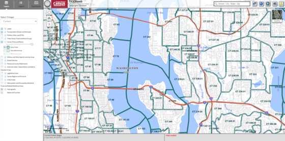
TIGERweb is a web-based system that allows users to visualize our TIGER (Topologically Integrated Geographic Encoding and Referencing system) data in several ways:
TIGERweb Applications
TIGERweb WMS
TIGERweb REST Services
The applications allow users to select features and view their attributes, to search for features by name or geocode, and to identify features by selecting them from a map. The TIGERweb applications provide a simple way to view our TIGER data without Geographic Information System (GIS) software and without downloading data. The applications use our TIGERweb REST Services.
The TIGERweb WMS and TIGERweb REST Services allow users to integrate Census Bureau geographic data into their own GIS or custom web-based applications.
|
|
About the Geography Program

Geography is central to the work of the Census Bureau, providing the framework for survey design, sample selection, data collection, tabulation, and dissemination. Geography provides meaning and context to statistical data.
|
|
|
|
Given the diversity of our population, our economic activities, and our geographic areas, use of the latest and best geographic methodologies is critical to the Census Bureau’s ability to serve as the leading provider of statistical and geospatial data. Our geographic area concepts, information, and statistical data must keep pace with the needs of the researchers and analysts who work to understand the changing distribution and characteristics of our people, places and economy.
|
|
|
|