|
Florida 177th Anniversary of Statehood (1845):
March 3, 2022
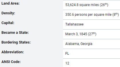
Florida joined the Union on March 3, 1845, as the 27th state.
Nickname: "The Sunshine State"
State Animal: Florida panther
State Bird: Mockingbird
State Freshwater Fish: Florida largemouth bass
State Marine Mammal: Manatee
State Reptile: Alligator
State Saltwater Fish: Atlantic sailfish
State Saltwater Mammal: Porpoise
State Salt Water Reptile: Loggerhead sea turtle
State Flower: Orange blossom
State Tree: Sabal palm
State Beverage: Orange juice
State Fruit: Orange
State Pie: Key lime pie
The United States acquired the area of Florida from Spain in 1819, although the area was not formally transferred until 1821. Florida Territory was organized on March 30, 1822, with generally the same boundary as the present state.
Census data for Florida are available beginning with the 1830 Census.
Data for the legally established state of Florida are available beginning with the 1850 Census.
Did You Know?
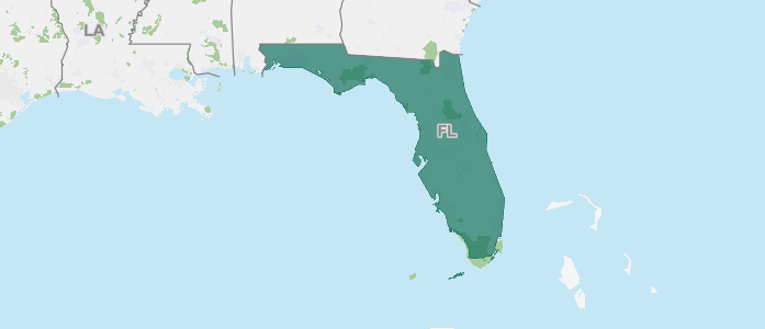
Florida has a land area of 53,633.7 square miles and a water area of 12,106.1 square miles. It is the 26th largest state by area. Florida is bordered by Alabama and Georgia.
|
|
|
|
The following facts are available thanks to the public's invaluable participation in U.S. Census Bureau surveys. We appreciate the information shared by each respondent as we continuously count and measure America's people, places, and economy.
The percentage of people in Florida who have obtained at least a bachelor's degree
The total number of housing units in Florida
The percentage of the labor force in Florida who are employed
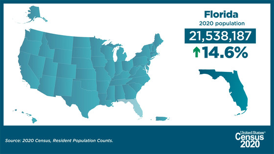
2020 Census: The Population of Florida
The number of people living in Florida was 21,538,187 as of April 1, 2020, an increase of 14.6% since the 2010 Census. View Florida's population change by decade.
Florida Was Third-Largest State in 2020 With Population of 21.5 Million
America Counts has launched a state-by-state look at the demographic changes the 2020 Census results reveal.
Our state profiles bring you key population characteristics of your state and your county all on one page.
See how they compare to the nation overall and to neighboring counties and states. Through interactive state and county maps for the 50 states, the District of Columbia and Puerto Rico, each page provides a snapshot of change from 2010 to 2020 on five topics.
Did you know?
- The numeric change in population for Florida from 2010-2020 was 2,736,877.
- The percentage of the population aged 18 and older in Florida was 80.5%, a total of 17,339,232 adults. This was an increase of 17.2% from the 2010 Census population aged 18 and older in Florida.
|
|
About the Geographic Areas
Florida has 10 federally recognized American Indian areas. There are seven reservations, one with associated off-reservation trust land. Two areas consist of trust lands only. There is also one off-reservation trust land associated with a reservation in Alabama. Florida has 20 metropolitan statistical areas, 10 micropolitan statistical areas, 3 metropolitan divisions, and 3 combined statistical areas. There are 67 counties in Florida.
|
Foreign Trade
Take a look at the various imports to and exports from Florida. See where materials such as pacific salmon, food preparations, fresh cut roses and buds, orthopedic or fracture appliances, contact lenses, gold (non-monetary and unwrought), motorboats, video game consoles and machines, and more rank on both lists.
Also, see lists of the countries that have sent the most imports by 2020 dollar value to Florida and the countries that have received the most exported goods from Florida as measured by 2020 dollar value.
|
|
View Florida Statistics in Our COVID-19 Data Hub
View the state COVID-19 impact planning report. Take a look at new survey data and estimates.
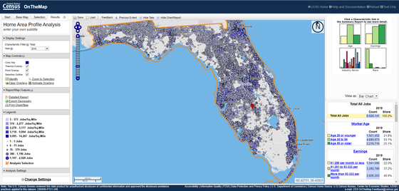
On the Map: Florida
OnTheMap Version 6 is the sixth generation of OnTheMap, a web-based mapping and reporting application that shows where workers are employed and where they live. It also provides companion reports on age, earnings, industry distributions, race, ethnicity, educational attainment, and sex.
OnTheMap provides an easy-to-use interface for creating, viewing, printing and downloading workforce related maps, profiles, and underlying data. Based on 2002-2018 LEHD Origin Destination Employment Statistics (LODES), OnTheMap is a unique resource for mapping the travel patterns of workers and identifying small-area workforce characteristics.
Looking For More Data and Information About Florida?
Customize the data that you receive from the Census Bureau. When you click on the link for your state below, we will be able to provide you with more timely and relevant information. We'll be able to send you state-specific updates, upcoming events in your area, job opportunities, interactive data visualizations, and more. Take the next step today!
 Help us spread the word about Census Bureau data. Share this newsletter on social media or forward it to a friend.
|
|
About the Census Bureau
We serve as the nation's leading provider of quality data about its people and economy. The Census Bureau is the federal government's largest statistical agency. As the world's premier statistical agency, we are dedicated to making our nation a better place. Policy-makers, businesses, and the public use our data to make informed decisions.
|
|
|
|
|