|
Texas 176th Anniversary of Statehood (1845):
December 29, 2021 |
|
|
|
|
|
|
| Texas joined the Union on December 29, 1845, as the 28th state. |
|
|
|
|
|
|
Nickname: "The Lone Star State"
State Motto: "Friendship"
State Bird: Northern mockingbird
State Large Mammal: Longhorn
State Small Mammal: Armadillo
State Reptile: Texas horned lizard
State Flower: Bluebonnet
State Fruit: Texas red grapefruit
State Folk Dance: Square dance
State Footwear: Cowboy boot
State Gem: Texas blue topaz
State Hat: Cowboy hat
State Music: Western swing
State Sport: Rodeo |
|
|
|
|
|
|
| Texas was originally part of Mexico, achieving independence as the Republic of Texas in 1836. The United States acquired the area of Texas through annexation and Texas was admitted to the Union on March 1, 1845, as the 28th state. At the time of statehood, Texas included part of present-day Colorado, Kansas, New Mexico, Oklahoma, and Wyoming. Texas sold territory to the United States in 1850 to assume generally the same boundary as the present state, but there were some subsequent revisions. In 1896, the Supreme Court ruled the Texas claim to the Greer County area in southwest Oklahoma to be invalid, and the area was officially deemed to be part of Oklahoma. An additional boundary dispute with Oklahoma was settled in 1930 by adding a narrow strip of territory to Texas. As the Rio Grande has changed its course, the United States and the Republic of Mexico have made periodic adjustments to their boundary that affected the boundary of Texas. |
|
|
|
|
|
|
| Census data for Texas are available beginning with the 1850 census. |
|
|
|
|
The following facts are available thanks to the public’s invaluable participation in U.S. Census Bureau surveys. We appreciate the information shared by each respondent as we continuously count and measure America’s people, places, and economy. |
|
|
|
|
|
The percentage of people in Texas who have obtained at least a bachelor's degree
|
|
|
|
|
|
The median household income in Texas
|
|
|
|
|
|
The percentage of the labor force in Texas who are employed
|
|
|
|
|
| 2020 Census: The Population of Texas |
|
|
|
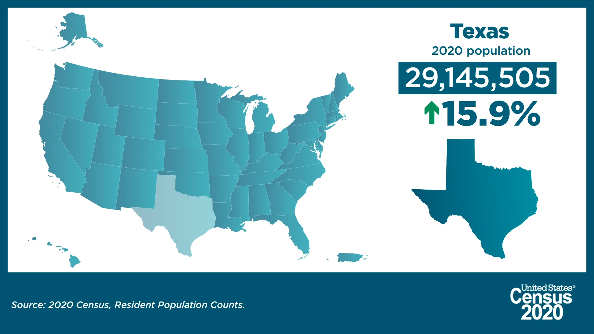
| The number of people living in Texas was 29,145,505 as of April 1, 2020, an increase of 15.9% since the 2010 Census. View Texas’ population change by decade. |
|
|
|
|
| Texas Added Almost 4 Million People in Last Decade |
|
|
|
| America Counts has launched a state-by-state look at the demographic changes the new 2020 Census results reveal. |
|
|
|
|
| Our state profiles bring you key population characteristics of your state and your county all on one page. |
|
|
|
|
| See how they compare to the nation overall and to neighboring counties and states. Through interactive state and county maps for the 50 states, the District of Columbia and Puerto Rico, each page provides a snapshot of change from 2010 to 2020 on five topics. |
|
|
|
|
Did you know?
- The numeric change in population for Texas from 2010-2020 was 3,999,944.
- The percentage of population aged 18 and older in Texas was 75.0%, a total of 21,866,700 adults. This was an increase of 19.6% from the 2010 Census population aged 18 and older in Texas.
|
|
|
|
|
 |
| About the Geographic Areas |
Texas has three federally recognized American Indian reservations, two with off-reservation trust land.
Texas has 25 metropolitan statistical areas, 44 micropolitan statistical areas, 2 metropolitan divisions, and 8 combined statistical areas. There are 254 counties in Texas. All counties are functioning governmental units, each governed by a Commissioners Court. |
|
|
|
|
|
| Foreign Trade |
Take a look at the various imports to and exports from Texas. See where materials such as passenger motor vehicles, road tractors for semi-trailers, parts of airplanes or helicopters, telephones for cellular networks or for other wireless networks, combined refrigerator-freezers fitted with separate external doors, petroleum oils and oils from bituminous minerals, natural gas in liquefied or gaseous form, liquefied propane, and more rank on both lists. Also, see lists of the countries that have sent the most imports by 2020 dollar value to Texas and the countries that have received the most exported goods from Texas as measured by 2020 dollar value.
|
|
|
|
|
|
|
|
|
|
|
|
| View Texas Statistics in Our COVID-19 Data Hub |
|
|
|
| View the state COVID-19 impact planning report. Take a look at new survey data and estimates. |
|
|
|
|
OnTheMap Version 6 is the sixth generation of OnTheMap, a web-based mapping and reporting application that shows where workers are employed and where they live. It also provides companion reports on age, earnings, industry distributions, race, ethnicity, educational attainment, and sex.
Race, Ethnicity, Educational Attainment, Sex, Firm Age, and Firm Size variables are made available in OnTheMap through a beta release of data.
OnTheMap provides an easy-to-use interface for creating, viewing, printing and downloading workforce related maps, profiles, and underlying data. Based on 2002-2018 LEHD Origin Destination Employment Statistics (LODES), OnTheMap is a unique resource for mapping the travel patterns of workers and identifying small-area workforce characteristics. |
|
|
|
|
Looking For More Data and Information About Texas? |
|
|
|
|
| Customize the data that you receive from the Census Bureau. When you click on the link for your state below, we will be able to provide you with more timely and relevant information. We'll be able to send you state-specific updates, upcoming events in your area, job opportunities, interactive data visualizations, and more. Take the next step today! |
|
|
|
|
Help us spread the word about Census Bureau data. Share this newsletter on social media or forward it to a friend. |
|
|
|
|
|
|
|
| About the Census Bureau |
| We serve as the nation’s leading provider of quality data about its people and economy. The Census Bureau is the federal government's largest statistical agency. As the world’s premier statistical agency, we are dedicated to making our nation a better place. Policy-makers, businesses, and the public use our data to make informed decisions. |
|
|
|
|
|
|
|
|
|
|