Torcross Sea Defence Repair
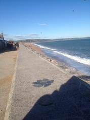 Following the storms last winter which caused damage at Torcross, the Environment
Agency is working to complete a repair to stabilise the existing flood defence.
The next phase of the Torcross project is the construction phase.
The Environment Agency are sending out regular updates to Slapton Line Partnership - click on "find out more" to read their latest update
|

Be Prepared this Winter
Simple ways to stay in touch with the people who know!

In the event of a storm or extreme weather, the best way to keep on top of what is going in is to follow our partners on social media.
Devon County Council, the Environment Agency and South Hams District Council are often the first people to find out when emergency situations develop and offer advice to help when the worst happens.
Here are some links that you might be useful, from knowing where to get weather warnings and road closure notices to clearing up after a flood:
Devon County Council Highways Agency publish alerts on road incidents @DevonAlert
The Met Office publish weather alerts @metofficeUK
The Environment Agency publish flood and incident alerts @EnvAgencySW
Promote Social Media #slaptonline and @
@environmentagencysw
@Devonalert
@FSCSlaptonley
@alandenbeigh
@torxboathouse
@startbayinn
Should the worst happen and the Slatpon Line is compromised, here are some alternative routes:
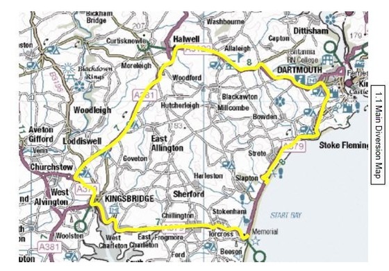 Main Diversion Route
The main diversion route will be brought into
effect following a closure of the A379 between Torcross and Strete Gate. From Torcross
to Strete Gate the diversion route uses the A379, the
A381 and
the A3122. From Strete Gate to Torcross the reverse route is to be used.
For a road closure between Slapton and Strete
Gate the ‘A’diversion signs are to be used. For a road closure between Torcross
and the road to Slapton Village - or in Torcross Village itself - the ‘B’
diversion route signs are to be used.
Road Closed signs will be used at either end of
the closure or at the appropriate location where turning is possible.
Road Ahead Closed signs will be placed in
Strete and Stokenham. Other signs (Businesses are open as usual etc.) may be
placed as required.
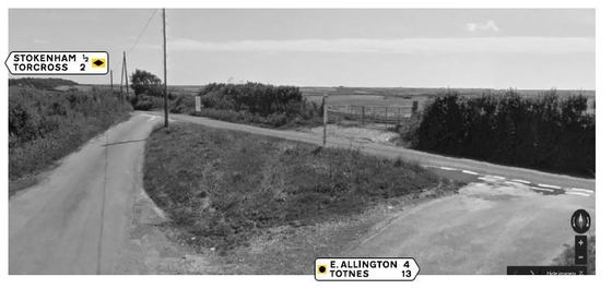 Alternative Routes for Light Traffic
Local drivers are likely to use minor
roads to access main destinations during a closure of the A379. To help avoid unnecessary
delays caused by northbound and southbound traffic meeting on the same minor
roads, a diversion route has been devised. This route is not to be publicised
to the general public, but local residents should be made aware.
The route is signed using standard
diversion route symbols, which have been added to the permanently mounted
directional signs in the area.
Northbound vehicles will be encouraged to follow circular symbols and |
|
 |
 |
|
Southbound drivers should follow diamonds. |
|