|
 |
Climate newsletter |
|
|
|
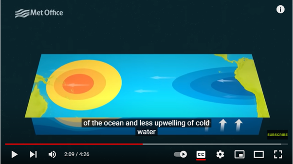
'El Niño' is the name of the warming of sea surface temperature that occurs every few years in the tropical Pacific. 'La Niña' is the term for opposite episodes with cooler-than-normal sea surface. These episodes alternate in an irregular interannual cycle called the ENSO ('El Niño Southern Oscillation') cycle. While the global climate system contains many processes, ENSO is by far the dominant feature of natural climate variability over the period of one year or more.
The last three northern hemisphere winters have seen a run of three consecutive La Niña events. This run of events, though unusual, has earlier precedents in the historical climate record, for example in 1999, 2000 and 2001 but this has now come to an end. Instead, the latest Met Office long-range forecasts suggest the tropical Pacific is about to transition into El Niño – the warm phase of ENSO.
Both historical observations and our physics-based computer models show that El Niño brings increased risk of drought to South-East Asia, India, North-Eastern Australia and parts of the Amazon and southern Africa and increased risk of cold conditions to northern Europe in winter. In addition to these regional impacts, ENSO also affects global temperatures, with El Niño raising global temperature slightly and La Niña reducing it slightly. Any increases are a few tenths of a degree and are much smaller than the current level of global warming of around 1.2 degrees that we have now accrued due to climate change, but it can be a significant driver in setting new global temperature records.
|
|
Researchers point the way to managing climate change risks
More research should be invested in trying to gain a greater understanding of so-called HILL events: those climate events which could have a High Impact, but only possess a Low Likelihood of occurring.
The Met Office's Dr Richard Wood led recent research with colleagues from other organisations. He said: "With HILL events we're talking about things that probably won't happen, but we need to be aware and prepare for the possibility, just in case." HILL events include the collapse of ice sheets and the disruption of major ocean currents.
First image from new generation of European weather satellites
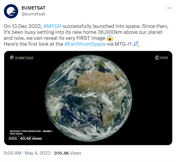 On 4 May, Europe’s meteorological satellite agency, EUMETSAT, and the European Space Agency (ESA) jointly released the image from the first satellite in the new generation of European weather satellites, Meteosat Third Generation – Imager 1 (MTG-I1). MTG-I1 was launched on 13 December 2022.
The MTG satellites are set to revolutionise national meteorological and hydrological services of Europe with improved resolution.
|
|
Webinar - Co-benefits of the climate action imperative
On 24 May 2023 from 15:00-16:00 BST, we will be hosting a webinar on the co-benefits of climate change action. We will discuss the co-benefits of climate action such as those on health and wellbeing. We will consider the cost benefit of taking action as well as the fact that many co-benefits will be realised more quickly than the impact on our changing climate. In addition to science and policy perspectives, we will also hear about how co-benefits are already being realised in some communities.
We will be joined by speakers from the University of Leeds, the UK Department for Energy Security and Net Zero, and Belfast City Council.
|
|
|
Follow us on the social media channels below to join the conversation.
#GetClimateReady
|
|
|
To subscribe or unsubscribe please visit our email updates page to access your preferences.
The Met Office is not responsible for the content of external internet sites.
|
|
|
|