Newly refurbished vessel safely returned to Tristan da Cunha
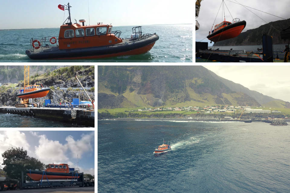
The Wave Dancer during her return journey and at sea back in Tristan Da Cunha.
The Wave Dancer is an important asset to the Tristan da Cunha community and beyond. The vessel has many uses including fishery patrol, scientific research, crew transfer, oil spill response and emergency response and rescue.
The Wave Dancer went to the UK for refurbishment in 2018 as part of the Blue Belt Programme. The refurbishment took over 850 hours including the fitting of two new engines. The refurbished vessel began the 8,777 return journey back to the Tristan da Cunha last September, arriving back to Tristan da Cunha onboard the cargo vessel the Baltic Trader. The Wave Dancer was discharged from the vessel over open water, but all went well and the vessel safely arrived in Calshot Harbour in December.
During the refurbishment Tristan da Cunha’s Senior Fisheries officer Rodney Green received over 850 hours of training on vessel maintenance, survival at sea, first aid, firefighting and safety awareness. He adds, “it’s great to have the Wave Dancer back on Tristan da Cunha. She’s such an important asset to the community. We’ve already tested the vessel around the island and clocked 35 knots, she has been used for the Tristan Darwin Marine Project ‘securing the future of the Tristan marine environment’ for deepwater camera deployments. It’s my intention to pass on my experience learnt from working at Berthon Marine to train other crew in the operation of the vessel and in the coming months”.
You can find out more on the Wave Dancer’s refurbishment in this video.
Underwater survey of coral communities around Pitcairn Island
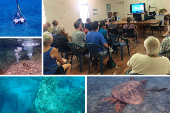
Clockwise: Blue Belt’s Paul Whomersley and JNCC’s Joey O’Conner talking the residents of Pitcairn through initial survey results and images from the underwater camera.
Last January the Blue Belt Programme and JNCC conducted a successful marine survey around Pitcairn Island. The survey studied marine habitats and the health and extent of coral communities using satellite imagery and a drop-down camera system.
Scientists took over 10 hours of video footage and 4,000 still images around Pitcairn Island during the survey. “We deployed the cameras in 60 different sites from a local small boat called Vai Pappa (Calm Waters). Several deployments of the drop frame were undertaken to help plan a permanent mooring buoy for visiting supply vessels to reduce the impact of anchoring in Pitcairn Island’s Bounty Bay” explains Blue Belt Programme Scientist Paul Whomersley from Cefas.
Initial results showed healthy inshore coral communities with colonies observed down to depths of 70m. The survey also revealed a variety of different marine habitats around Pitcairn Island including coral and rock communities, rippled sand, algal covered exposed bed rock and exposed bedrock with coral communities. Following the survey, Blue Belt’s Paul Whomersley and JNCC’s Joey O’Conner shared their initial findings with Pitcairn Island residents.
Trialing innovative technology in the UK Overseas Territories
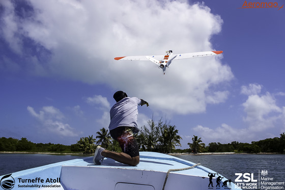
Photo credit: Three Wise Monkeys Productions.
It is estimated that one in five fish worldwide is caught illegally. If illegal fishing continues in this way, there could be dire consequences on the health of the ocean’s, and for all that depend on it. Tackling illegal, unreported and unregulated fishing (IUU) is a key part of the Blue Belt Programme.
The Blue Belt Programme has been trialling a fixed wing drone to help tackle the issue in the UK Overseas Territories (UKOTs), helping to support fisheries patrol vessels increasing the area of surveillance. As the UKOTs are difficult to reach, early trials were carried out in Belize and Uganda where the team could mimic conditions in UKOTs, working in partnership with the Zoology Society of London and Turneffe Attol Sustainability Association in Belize.
The trials tested if the drone could complete multiple flights in one day, operate beyond the visual line of site, and return to a moving target. “We’ve just completed the final phase of drone trialling in British Indian Ocean Territory where the drone was used alongside a fishery patrol vessel and satellite positioning technology” explains Blue Belt Programme’s Dan Ward from the MMO.
The aspiration for the future is the long-term operational use of the drone to reduce IUU and help protect the oceans in the UKOTs.
St Helena seamount added to global map of the seafloor

An underwater mountain double the height of the UK’s Ben Nevis has been added to a global map of the seafloor. The underwater mountain, known as a seamount, was mapped during the joint 2018 Blue Belt Programme British Antarctic Survey (BAS) survey to St Helena and Tristan da Cunha.
Even from the best available maps, scientists knew little about the underwater mountain before arriving to the area. “As a general rule, the vast majority of the deep ocean floor is very poorly mapped and Tristan da Cunha and St Helena are no exception. In most areas, the resolution of the best available maps is something in the order of about 1km2” explains Blue Belt Programme scientist Tammy Stamford.
The team were taken to the approximate location of the seamount by St Helena fishermen using a technique called ‘swath bathymetry’ to construct a picture of the underwater structure. They bounced sound pulses from the ship to the seabed to build an accurate picture of the seamount. They saw a massive 400x increase in horizontal resolution after taking the measurements.
The seamount was added to the global map of the seafloor by the International Hydrographic Organisation last November. It received its name from the residents of St Helena after a competition to find a name. The winning entry “Charlie Boar” was the nickname of Mr Charles Henry – a local fishermen, sailor and merchant seaman who passed away in 2018. Read more about the seamount here.
Technology roadmap project nears completion
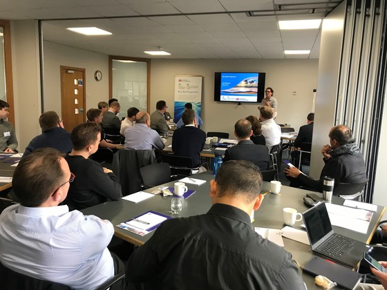
Blue Belt's Katie McPherson presenting at the Technology Roadmap Workshop.
A project exploring the use of innovative technology for each UK Overseas Territory (UKOT) is nearing completion. On 27 February Marine South East hosted a workshop in London attended by a range of people including UKOT representatives, government, the technology industry and non-government organisations. The conclusions of the project will help the Blue Belt Programme and each UKOT understand which technology options would be the best for them with a focus on tackling illegal fishing in their marine areas.
Blue Belt's Katie Morton said ‘it's an exciting project to be part of and the workshop was a great opportunity to bring together people from different perspectives and with varying expertise, I’d like to thank those who took part. The next step will be to finalise the report and draw on its findings for the next phase of the Blue Belt Programme’.
More information about the project can be found here.
Minimising and monitoring the risk to the marine environment of invasive, non-native species
To support our cross-cutting work on minimising the risk from marine invasive non-native species (INNS), the Marine Management Organisation has worked with the Joint Nature Conservation Committee (JNCC) on a collaboration on behalf of the GB Non-Native Species Secretariat (NNSS) to develop a Marine Biosecurity Toolkit for the UK Overseas Territories (UKOTs).
The Marine Biosecurity Toolkit provides practical guidance to the OTs to reduce the risk of introducing marine INNS and to identify any marine INNS that might already be present in their waters.The toolkit contains identification guides, risk assessment tools and more.
Hard copies of the Marine Biosecurity Toolkit will be sent to all 14 of the UK Overseas Territories and are available to download on the NNSS website here.
Blue Belt Programme communications survey results
We recently carried out a short survey to get your views on Blue Belt communications. We asked questions about frequency and content of newsletters, social media channels, our website and events. Responses varied from those based in UK Overseas Territories (UKOTs) to government bodies, academics and non-government organisations.
You said… you liked the Blue Belt annual update and the newsletter but the website could be improved. Many of you don’t use Twitter, preferring other social media channels such as Facebook or LinkedIn. More on island support with communications would be welcomed and you would like to see more information about progress and successes of the programme and networks developed between UKOTs. You would like to see more Blue Belt stories in UKOT newspapers or media outlets and in the UK media too. You would welcome more updates on the Blue Belt webpages and more frequent newsletters.
We will… consider your views and preferences on how we engage with you to plan our communications activities over the next year. Over the next few months we’ll be working on our Blue Belt Programme end of programme report and reviewing our social media channels and on-island communications. We would like to thank those who took the time to respond to the survey - we really value your responses.
You can subscribe to future editions of the Blue Belt Programme newsletter here.
|