- Local Plan update
- New Local Plan evidence work
- New online mapping information
- Neighbourhood Plans update
-
Adoption of the South Pennine Moors Supplementary Planning Document
Over 31,000 representations on emerging new Bradford District Local Plan!
Last year the draft Local Plan for the Bradford District was published for consultation. The consultation generated a huge response over the 6-week period with the Council receiving over 31,000 representations from members of the public, stakeholders and organisations on the proposed policies and suggested site allocations and designations.
During the consultation planning policy officers hosted 22 online workshop events which provided the opportunity for people to learn more about the plan and ask questions.
The emerging Local Plan sets out a clear spatial direction for the District with integrated strategic and thematic policies to help in decision making, new site allocations and land designations and a monitoring framework.
Summaries of the representations received can now be viewed online via the OpusConsult consultation system.
We would like to thank all those who participated in this consultation and provided feedback on the proposals.
The comments have been analysed and informed further work. the Statement of Consultation report will summarise the issues raised and provide the Council's response. The Statement of Consultation report will be available during the next consultation stage (Regulation 19 Publication Draft) planned for later this year.
|
New Local Plan - evidence work
Progress continues to be made updating the emerging new Local Plan evidence base including the following:
Transport - consultants AECOM are now working with the Council and stakeholders on the production of local plan evidence work on transport. This is a major area of work covering the District and evaluating the implications of emerging site allocations in terms of traffic and movement, plus air quality and carbon profiling.
Flood risk - consultants JBA are continuing to work alongside the Council and the Environment Agency on updates to strategic flood risk assessment information.
Viability - specialist property regeneration consultants Aspinall Verdi have also been commissioned to support the Council on updates to viability and delivery evidence for the Local Plan. This is again a district wide study covering and testing emerging planning policies and site allocations.
Ecology, Heritage Impacts and Site Accessibility - evidence work have also been progressed by West Yorkshire Ecology Services on an ecological review of emerging allocations and specialist officers have also been progressing heritage impacts assessments and site accessibility analysis.
Retail and Centres - officers are also producing updates on changes in retail and city, town, district and local centre uses and annual updates to housing completions. Additional work is also being progressed on a further review of urban capacity – particularly within the Regional City.
In addition to the above, further work is being progressed or procured relating to sustainability appraisal, area based masterplanning and design frameworks for key sites.
New Online Mapping Information
The Council has been busy working on developing new online interactive maps for a number of themes. Please click on the links below to access the maps, alternatively visit the Local Plan webpages.
A new map is available covering call for sites information gathered as part of the Local Plan consultation. Please click the link below to view these sites.
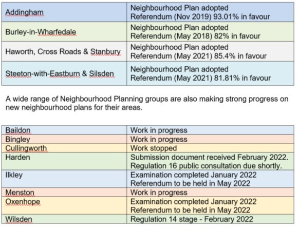
Since the last newsletter two new Neighbourhood Plans have now been adopted, covering Haworth, Cross Roads & Stanbury and Steeton-with-Eastburn & Silsden. This involved a high level of local community involvement, independent examinations and successful public referendums. Four adopted Neighbourhood Plans now form part of the statutory development plan for the Bradford District.
 For further information about Neighbourhood Planning or any of the Neighbourhood Plans listed above, please visit the Neighbourhood Planning webpages.
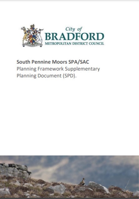
South Pennine Moors SPA / SAC Supplementary Planning Document (SPD)
On the 4th January 2022, Bradford Council adopted a new South Pennine Moors Supplementary Planning Document (SPD).
The SPD relates to the South Pennine Moors, which are classified as a Special Protection Area (SPA) and designated as a Special Area of Conservation (SAC).
The South Pennine Moors SPA/SAC Planning Framework SPD provides guidance and information to enable planning officers and developers to understand the necessary steps that need to be taken to ensure compliance with the Conservation of Habitats and Species Regulations 2017 (as amended by The Conservation of Habitats and Species (Amendment) (EU Exit) Regulations 2019) ('the Habitats Regulations').
The SPD relates to the South Pennine Moors, which are classified as a Special Protection Area (SPA) and designated as a Special Area of Conservation (SAC).
Policy SC8 of the adopted Core Strategy sets out a zonal approach to development which may affect the South Pennine Moors SPA/SAC. The SPD sets out the recommended developer contribution (tariff) payable in order to avoid or mitigate any adverse impacts on the internationally protected species and habitats, that arise from development that falls within these zones. The monies collected will be used to fund a series of measures as part of the strategic mitigation strategy for the management of the SPA/SAC.
Further information is available on the South Pennine Moors SPD webpage.
|
|