|
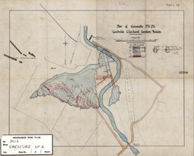
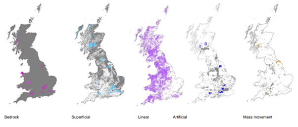
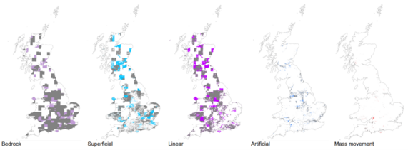
Updates to the BGS geology 1:50 000 scale and 1:10 000 scale digital geology maps have recently been published. Updates include the addition of new data and slight modifications to the dataset attribution. An overview of the changes have been provided with the data release and the images below provide summarise the spatial distribution of updates between Version 8 and the incoming Version 9 of the 1:50 000 scale maps and between Version 2 and the incoming Version 3 of the 1:10 000 scale maps.
 (Coastline Contains OS data © Crown copyright and database right 2025. OS AC0000824781)
Above: Locations of new or modified content in BGS geology 1:50 000 Version 9. Bedrock changes (pink), Superficial changes (light blue), Linear changes (purple), Artificial changes (dark blue), Mass-movement changes (brown).
 (Coastline Contains OS data © Crown copyright and database right 2025. OS AC0000824781)
Above: Locations of new or modified content in BGS geology 1:10 000 Version 3 by comparison with Version 2 (V2 coverage shown in grey, V3 in colour). Bedrock changes (purple), Superficial changes (light blue), Linear changes (pink), Artificial changes (dark blue), Mass-movement changes (brown).
For more information about this latest release, please visit the BGS website.
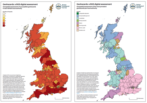 Scientists at the British Geological Survey (BGS) have published UK regional hazard maps revealing the most susceptible local authority regions around the country. The maps provide regional decision makers with an overview of the relevant hazards in their local area and provide an important indication of where more detailed hazard data may be required. The analysis considers the occurrence of eight key geohazards relating to natural subsidence, the presence of the ground-gas radon, and the possibility of legacy mining in an area (excluding coal). Further information about these maps, including how to access, is available on our website.
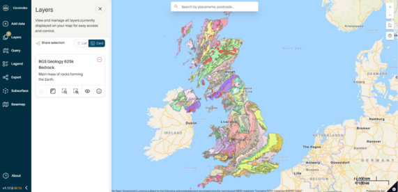
First launched in July 2000, the BGS GeoIndex is a professional digital geological map application and receives over one million views each year. The refreshed and upgraded user interface has been designed to enhance the user experience, with improved find and filter tools to make it easier to access the relevant data. Direct links to full Discovery Metadata records have been added to provide deeper insights and there are expanded basemap options, including the latest Ordnance Survey maps and high-resolution satellite imagery.
The beta release also includes core geological data layers, such as 625K- and 50K-scale digital geological mapping and borehole datasets, to allow for focused user testing. We are looking at eventually streamlining some of the other currently available data layers as part of the review, to ensure the new platform is as user friendly as possible.
> access the new GeoIndex beta release
We would welcome user feedback during this beta phase, and comments can be submitted through the GeoIndex online feedback form.
BGS open data releases
 |
|
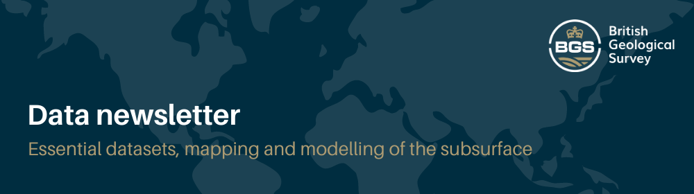
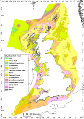
New seabed sediment maps
BGS has developed the new national-scale BGS Predictive Seabed Sediments (UK) dataset comprising four digital maps that portray sediment composition, including a classified map of sediment types, as well as the predicted proportions of gravel, sand and mud across the UK continental shelf.
These detailed maps are based on around 40 000 sample measurements, as well as numerous physical covariates that relate to the spatial distribution of seabed sediments.
Find out more about this release and how to access the maps on our website.
|
 |
|
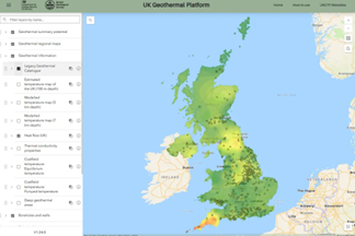
BGS has launched the UK Geothermal Platform, which provides national- to local-scale information on geothermal potential across shallow and deep technology options. It allows users to explore and assess the geothermal potential of an area and make more informed decisions. The platform draws together diverse information and synthesises it to deliver the information needed by heat policy, heat networks, national zoning model and planning specialists. The platform can be used by regulators, developers and researchers. To find out more please visit our website. |
 |
|
Artificial Ground: what do you need from a geological survey?
BGS is continually reviewing its data offerings to ensure they remain fit for purpose and identify potential updates and improvements. A huge thank you to all those who recently provided feedback on the BGS Geology digital maps. Compilation and analysis of the results is ongoing and the results will inform the development of future iterations of the BGS Geology maps at all scales.
Implementing effective change requires input from all our stakeholder groups and we’d like to hear from you. Ongoing engagement campaigns include BGS artificial ground data. BGS is seeking more detailed user feedback on artificial ground data: how you use it, what information you consider, and what we can do to improve our offering.
> Take the survey
|
Events:
 |
|
BGS hosted the British Cartographic Society Annual Conference in September. The two-day event consisted of parallel sessions. Firstly, the Map Curators Group which included a show and tell session of the BGS library and archives displaying the gems BGS holds
including maps related to historical events and pioneering geology. Alongside this a series of GeoViz workshops with BGS contribution on how geological cross sections are made using geological data and expertise when out in the field to understand the subsurface. The main second day of the conference was themed on ‘Managing Our Landscapes’ and consisted of a wide range of talks from industry including how geological mapping has evolved over time to our latest mapping techniques. The talk also covered how this data is then transferred to BGS data products. The day proved to be a great way to showcase the knowledge, collections and facilities that BGS possess.
In November, BGS Products will be attending the Government Geography Profession Conference 2025. If you are attending, please come along and speak to us about our data products and how we can help you.
|
If you would like to talk to BGS about commercial applications of our data products, please contact BGS Digital Data (digitaldata@bgs.ac.uk).
For more information on our data products, please visit:
https://www.bgs.ac.uk/geological-data/datasets/
|