New study reveals value of National Geological Repository to UK economy

Having trouble viewing this email? View it as a Web page.

BGS Latest News
The Core Store in Keyworth. Part of the National Geological Repository. It is a warehouse full of cardboard boxes of core.

New study reveals geological facility’s value to UK economy

The National Geological Repository (NGR) is a gateway to our shared subsurface. It is the UK’s most comprehensive collection of geological materials, consisting of over 16 million specimens and assembled over 200 years. For the first time, an economic valuation report has brought into focus the scale of the National Geological Repository’s impact on major infrastructure projects.

Located at BGS’s headquarters in Keyworth, the NGR is home to the UK’s largest core storage and examination facility. Of particular value to industry and infrastructure projects are over 600 km of pre-drilled core from around the UK, which provide considerable cost and time-saving benefits.

The economic analysis shows that the NGR has delivered:

  • £1.5 billion in avoided drilling and analysis costs for major energy and infrastructure projects over the last 20 years
  • Up to 36 times return on investment based on costs of maintaining the facility
  • Time-savings of around three years per infrastructure project through access to legacy core samples

For more information, including access to the report, please visit our website

UK Hazard Maps

Is your region susceptible? Britain’s geohazard hotspots revealed

New maps published by BGS provide regional decision makers with an overview of geohazards in their local area and provide an important indication of where more detailed data may be required.

The analysis considers the occurrence of eight key geohazards relating to natural subsidence, the presence of the ground-gas radon, and the possibility of legacy mining in an area.

tsunami damage

BGS scientists work with United Nations to update hazard profiles

From tsunamis to sinkholes, the the UN Hazard Information Profiles (HIPs) provide a standardised, internationally agreed definition of hazards to support disaster risk management worldwide.

The latest iteration of the profiles spans over 280 hazards. BGS scientists Dr Julia Crummy and Prof John Rees have coordinated the review of the geological HIPs, in collaboration with over 50 experts.

In other news

The ECORD IODP3 Expedition 501 science team on board Liftboat Robert.

IODP³-NSF Expedition 501: successful offshore operations launches onshore phase

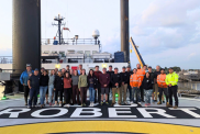
Seventy-four days offshore, 718 cores and 871.83 m of total core from three locations: this is the successful outcome after the end of offshore operations of IODP³-NSF Expedition 501: New England Shelf hydrogeology. The goal of the expedition was to take samples not only of sediment cores, but also of the water stored in both sandy aquifers and clayey aquitards beneath the ocean floor. Their existence has been known for decades but they remained virtually unexplored — until now.


Seismogram of Kamchatka earthquake on 29 July 2025

Kamchatka earthquake highlights the advances in tsunami early warning systems

On 29 July 2025, global monitoring systems detected a large earthquake offshore of the Kamchatka Peninsula, Russia, and widespread tsunami warnings were issued across the Pacific region.

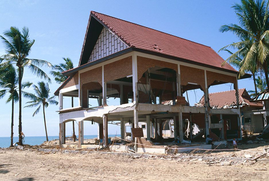
Almost as soon as news broke of the earthquake, tsunami warnings were issued and millions of people were told to evacuate across locations at risk, 2 million in Japan alone. This was the result of two decades of research on hazard mitigation following the Boxing Day earthquake in 2004, which claimed the lives of more than 220 000 people in one of the largest disasters, in terms of loss of life, in modern history.


UTES consortium

Join our consortium - de-risking underground thermal energy storage

BGS is inviting interested parties to investigate how site-scale geological data can be used to optimise thermal storage scheme performance.


Railway cutting example

BGS artificial ground data: what do you need from a geological survey?

BGS is seeking user feedback on artificial ground data: how you use it, what information you consider, and what we can do to improve our offering.


An image of Stonehenge on a cloudy day. The grass below is green, and a bit scorched in places.

Scientists uncover secrets of Stonehenge's mysterious cattle

The mysteries of Stonehenge have baffled scientists for centuries. In the 2010s, archaeologists and geologists identified two quarries in Wales as the sources of Stonehenge’s legendary standing bluestones. Now, new evidence published by scientists in August 2025 consolidates this connection.


Upcoming events 

Sands of time event

Sands of Change: The Global Challenges of Sand Mining

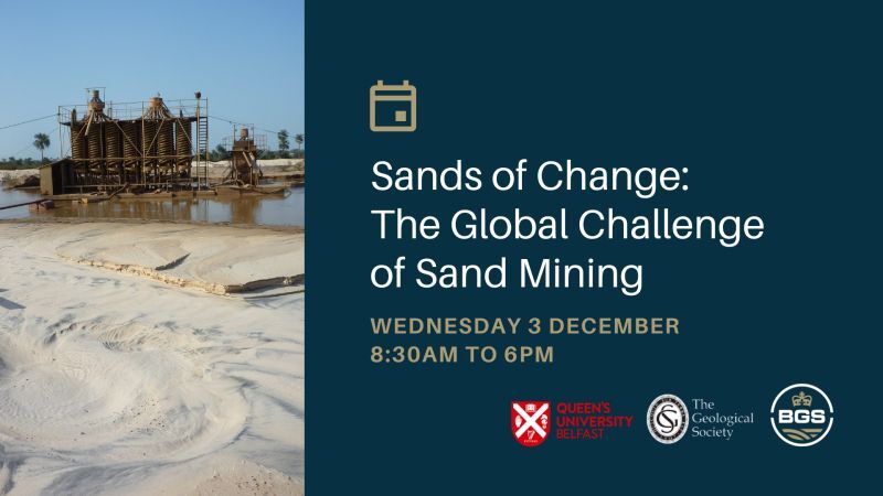
Wednesday 3 December - 8.30am to 6pm

Sand is one of the most important industrial raw materials on the planet and is the second most utilised resource on Earth, after water.

For many, sand is seen as a freely available and easily extracted material, however the mismanagement of sand can create huge economic and ecological issues. Illegal sand mining and extraction is now an industry worth an estimated $200 to 350 billion per year. 

Geoscience can play a crucial role in the monitoring and management of both legal and illegal sand resources, from sourcing the location of deposits, understanding the chemical and physical properties of sand, through to modelling the impacts of extraction and understanding how we can reduce our reliance on sand for a sustainable future.

Join us on 3 December as we discuss the sand mining trade and how we can create a more sustainable practice, and potentially reduce future dependence on sand.

> Register for your ticket online