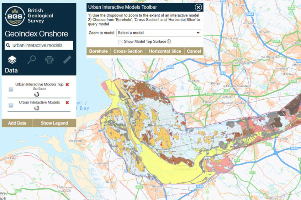
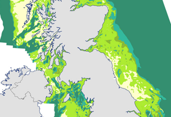
The Urban Interactive 3D models tool, hosted within BGS GeoIndex (onshore), was launched as a free-to-view service in 2021. It already includes conceptual models of London and the Thames valley, Cardiff, and the greater Glasgow region; now, a model featuring Liverpool and Warrington has also been made available. The tool provides a 3D characterisation of the rocks and deposits beneath the area that make up the upper tens to hundreds of metres of the below ground. This data provides a vital understanding of where certain geology is and can assist different sectors in their planning within urban areas.
|
|
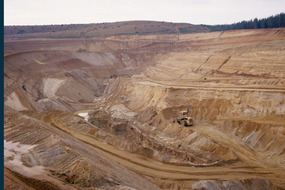
The latest release of the BGS BritPits dataset provides information on an additional 6500 surface and underground mineral workings and now covers more than 260 000 mineral workings in Great Britain, Northern Ireland, the Isle of Man and the Channel Islands. The data includes active, inactive, dormant and ceased sites and each entry describes an onshore mineral working in terms of its name, operational status, geographical location, Mineral Planning Authority, operator, the geology worked and the mineral commodity produced. The data is available as licenced or open packages. Find out more about the BritPits dataset on our website.
|
|

In 2023 Bluesky released an update to their National Tree Map, a key input to BGS PSA, which extended coverage to Scotland. BGS is now able to offer PSA to the conveyancing sector with national coverage for Great Britain offering building-level subsidence assessments for over 1.5 million additional buildings and summaries for over 100 000 additional postcodes. Find out more about our PSA data product on our website.
|
|
|
In other data news
Update on changes to BGS data product licence fees from 1 April 2025
As a result of our annual price review BGS will apply, in most cases, a 5 per cent increase* to our direct licence fees for our data products from 1 April 2025.This means that any direct licence issued or renewed on or after 1 April 2025 will reflect this increased price. Existing data licensees will not be affected until such time as their licence is next due for renewal, after 1 April 2025. BGS undertakes annual price reviews and will communicate any future licence fee changes (from 2026) as appropriate.
If you have any queries regarding this matter, please contact the IPR digital team (iprdigital@bgs.ac.uk).
* Due to the specific pricing of individual datasets please note not all price changes will equate exactly to 5 per cent.
|
Seabed geology data: results from stakeholder consultation
In the September 2025 edition of this newsletter we invited you to complete a stakeholder engagement survey proving feedback as part of a new Crown Estate-led initiative to improve understanding of national-scale seabed geology requirements.
The project aims to better understand the current and future requirements for national-scale seabed geology and shallow subsurface information across multiple marine sectors, focusing on offshore renewables, linear assets and nature.
The BGS Offshore data team are grateful for your contributions and have published the results of this consultation on the BGS website.
|
Events and conferences
Colleagues from the BGS Digital products and Business Development teams have been busy attending industry events and engaging with our valued stakeholders.
Government Geography Profession Conference (GGP)
This year’s GGP conference took place at the Ordnance Survey offices in Southampton, featuring 24 presentations over two days. The event highlighted a wide range of geographical achievements across public services, with a strong focus on GIS analysis, the use of artificial intelligence and machine learning in geographical studies, and advancements in GIS tools.
BGS presented three posters alongside others presented by Defra, Natural England, and the Office of National Statistics. The GGP conference provides an excellent platform to showcase and share geographical activities, fostering collaboration and communication among like-minded organisations across the public sector.
|
AGI Scotland GeoCom Conference
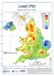
Paul Everett, geochemical survey expert at BGS presented at the AGI Scotland GeoCom conference in Edinburgh. He delivered a talk titled “British Geological Survey: releasing geological intelligence to society” providing an overview of the contents of the BGS Data Products portfolio, and our platforms for delivering access to end users.
The development and delivery of the recently released UK topsoil geochemistry data product was described in focus, as an example of a detailed landmark dataset that we have made freely available to the public and research community.
|
We would love to hear from you!
If you would like to talk to BGS about commercial applications of our data products, please contact BGS Digital Data (digitaldata@bgs.ac.uk).
For more information on our data products, please visit:
https://www.bgs.ac.uk/geological-data/datasets/
|
|
|
|