Tracking the Santorini earthquake swarm with AI

Having trouble viewing this email? View it as a Web page.

BGS Latest News
AI detected seismic activity in red, versus traditionally detected activity in brown.

Artificial intelligence is proving a game changer in tracking the Santorini earthquake swarm

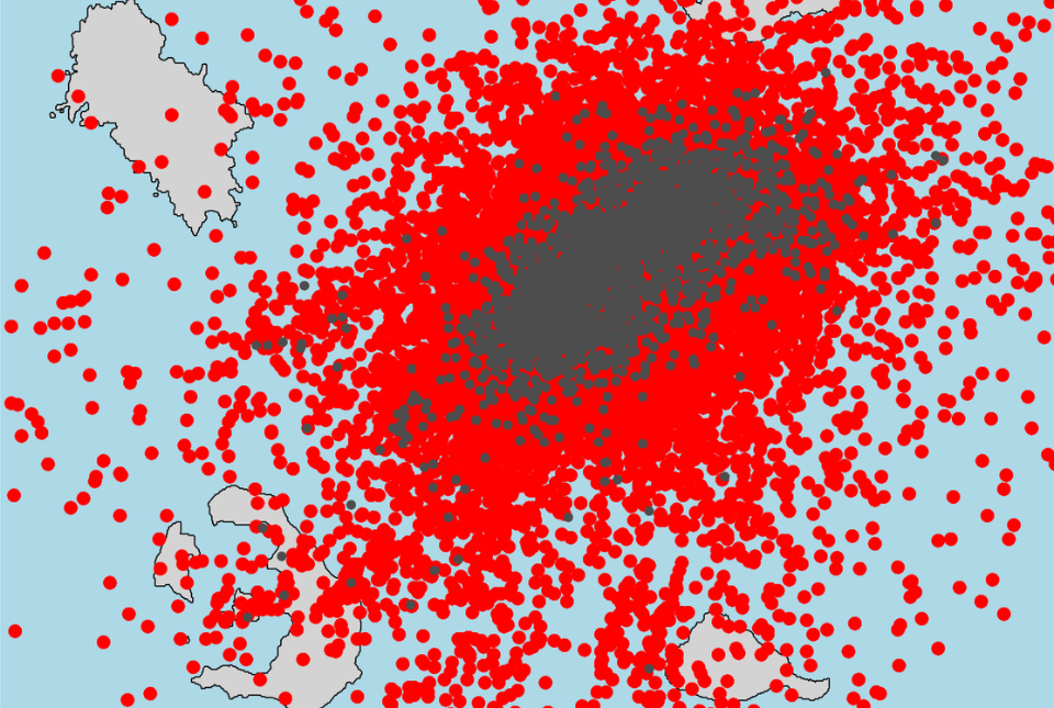
As a state of emergency is declared on the Greek island of Santorini, seismologists are increasingly turning to artificial intelligence technology to provide high-resolution images of the ongoing seismic activity, in a bid to enhance short-term forecasting accuracy.

Since the start of the crisis, a team from BGS comprising Margarita Segou, Brian Baptie, Rajat Choudhary, Wayne Shelley and Foteini Dervisi, have been employing machine learning algorithms to detect ten times as many earthquakes as standard techniques. This approach is allowing geologists to identify for the first time small magnitude earthquakes that were previously undetected using standard approaches.

Excess rainwater on agricultural land near West Ilsley, next to the A34.

Pioneering tool expanding to analyse agricultural pollution and support water-quality interventions

Road Pollution Solutions is a first-of-its-kind online tool that predicts which roads create the most run-off pollutants. Its capabilities are now being extended to also estimate the number of pollutants, including fertilisers and pesticides, that are transported into rivers in rural areas.

Jonathan Ford - BGS Director of National Geoscience

BGS announces new director of BGS National Geoscience

BGS is pleased to announce that Jonathan Ford has been appointed as the new director of BGS National Geoscience.

The national geoscience programme forms a core part of BGS and underpins its role as the UK’s national geological survey.

In other news

An illustration of a house standing on soils that could subside for various reasons. Copyright BGS / UKRI

What is a sinkhole and how are they formed?

Dr Andrew Farrant spoke to the BBC to explain how sinkholes occur, following the two sinkholes that recently occurred in Godstone, Surrey. 


Extract from existing Quaternary thickness geological factor map produced as part of collaboration between BGS and The Crown Estate in 2014.

Seabed geology data: results from stakeholder consultation

BGS collected valuable stakeholder feedback as part of a new Crown Estate-led initiative to improve understanding of national-scale seabed geology requirements. The findings from this survey have now been made available to view online.

NERC laboratory

Call for new members and chairs to join the NERC Facilities Steering Committees

BGS is looking for new members to the committees over the next four years. The four facilities within this call are the: Geophysical Equipment Facility, Ion Microprobe Facility, National Environmental Isotope Facility and the NERC Environmental Omics Facility.


On the blog

The flag of India, flying in a blue sky

Could underground disposal of carbon dioxide help to reduce India’s emissions?

Balancing climate targets against increasing emissions, which are driven by the expansion of core industrial sectors, represents a significant challenge for growing economies such as India.

BGS geologists have partnered with research institutes in the country to explore the potential for carbon capture and storage, with our role focusing on potential storage solutions.


Upcoming events

The graphic for the Mine Water Energy Symposium, taking place on 7 and 8 May

The Mine Water Energy Symposium is returning following a run of successful events in previous years. Over the two days there will be online talks from both UK and international participants.

The event is co-organised by the British Geological Survey, the Mining Remediation Authority, the Department of Energy Security and Net Zero (DESNZ - UK Government) and IEA Geothermal.

> Register online