|
The BGS Data newsletter provides a roundup of the latest news and activities from the BGS Data and Products teams. We strive to continue to improve and incorporate new research whilst keeping up-to-date with user requirements via a range of events and activities including the data users group and holding innovation boot camps, data sprints and hackathons. Continue reading for all our latest news, releases and updates.
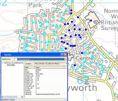
Used extensively across the insurance market, the BGS GeoSure Insurance Product gives an index-level assessment of the potential for a geological deposit to create financial insurance loss due to natural ground movement.
It incorporates the combined effects of the six BGS GeoSure hazards on (low-rise) buildings and links these to a postcode database (the derived postcode database).
The latest release, updated with OS postcodes, is now available and being shared with licensees and data partners. For further information contact digitaldata@bgs.ac.uk.
|

The insurance and mortgage sectors are increasingly concerned with climate change related geohazard risks across their portfolios, including:
- subsidence
- landslides
- coastal erosion
- groundwater flooding
The Bank of England’s climate-related stress testing framework allows for the exploration of impacts and exposures under a range of potential climate pathways, for which BGS datasets provide important insight.
Our sector specific climate change data webpages provide an overview of BGS data available to support climate-related stress testing and other climate change challenges.
|
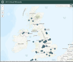
The UK Critical Minerals Intelligence Centre (CMIC) supports the UK in securing adequate, timely and sustainable supplies of the minerals and metals it requires to transition its economy to net zero emissions in the coming decades.
Led by BGS with support from what was the Department for Business, Energy & Industrial Strategy (BEIS), CMIC is working collaboratively with universities and private and public sector partners to gather and analyse intelligence on the supply and demand of critical minerals, their global value chains and their use by UK industry.
The CMIC interactive map shows UK mineral processing and refining, chemical and metal production, recycling and associated development activities, with more data being added as the programme continues.
|
As part of the Geospatial Commission's National Land Data Programme, BGS is working with the Food, Farming and Countryside Commission in Devon to support the design and development of a local land-use framework and decision-making tool.
The National Land Data Programme is exploring the UK’s key land-use challenges, such as energy, housing and decarbonisation, and how spatial data and modelling can support better decisions about land use prioritisation and change.
|
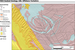
The latest of our fine-scale offshore maps to be released is that of the Yorkshire coast, showing the bedrock, sediment, bedrock structure and seabed geomorphology of the area. The Yorkshire map follows the release of our previous maps in the series: the Dorset coast, the Bristol Channel and Anglesey. All the maps can be viewed on the BGS Offshore GeoIndex.
These fine-scale (around 10K to 50K resolution) maps provide important evidence for policy and decision makers, who need to consider the increasing demands being placed on the marine environment. These demands may come from, for example, renewable energy, resource availability, recreation and marine conservation interests.
|
BGS recently released the AGS File Utilities Tool and API for the geotechnical community.
AGS data is the industry-standard exchange format for geotechnical data in the UK. The format provides a means of transferring geotechnical and geoenvironmental data between parties in a standard data exchange format (.ags).
The tool and API offer validation of AGS files using the Official AGS Python Library, so users will get the same result as when using the Official AGS Validator Tool for Windows. To streamline the process, data checking that conforms to the National Geoscience Data Centre AGS submission guidelines is included. Additionally, users can convert their AGS files to and from MS Excel (.xslx) files.
BGS has made the underlying API public for any data scientists or GIS analysts to use directly. The codebase is open source and available on the GitHub.
Try it out: https://agsapi.bgs.ac.uk/
On the blog:
In our latest blogs, we discuss and compare the available range of shrink–swell subsidence products and how to use them, plus information about the BGS Property Subsidence Assessment product that provides data to help mitigate property-specific subsidence.
|