In This Issue:
Did someone forward this email to you? Subscribe now -- it's free!
We have so little time on this Earth to affect real change. But what does that mean? Changing the course of human history? A lofty goal indeed. Perhaps changing the fortunes of your family? A modest, yet equally meaningful pursuit. Truth be told, it’s doubtful one could argue against the latter not contributing to the former. Either way we acknowledge the accompanying sense of urgency to do what we can with the time we’ve been given. Perhaps the desire to affect change is really more akin to us asking, “How do we want to be remembered?” The only catch is that most people aren’t waking up each morning with this singular thought in mind. Rather they tackle each day as it comes, using their natural abilities, curiosities, passion, and personal experience to navigate this complex world. And it is through these common, selfless acts that one can build a life and a career that has meaning. A life and career that unsuspectingly shapes the lives of those around them. These people take different forms, are called by different names, but their gifts are undeniable. This month we remember just such an individual, a man who dedicated his life to wildlife and the people of Texas, and who will forever been thought of and remembered fondly for his immeasurable contributions to our great state and the many people who have the privilege to meet or know him.
By: Small Game Program Team
Carl Frentress Unit Dedication
“Stewardship of natural resources is a component of citizenship…our very well being has to do with the fate of how our resources are handled.” - Carl Frentress
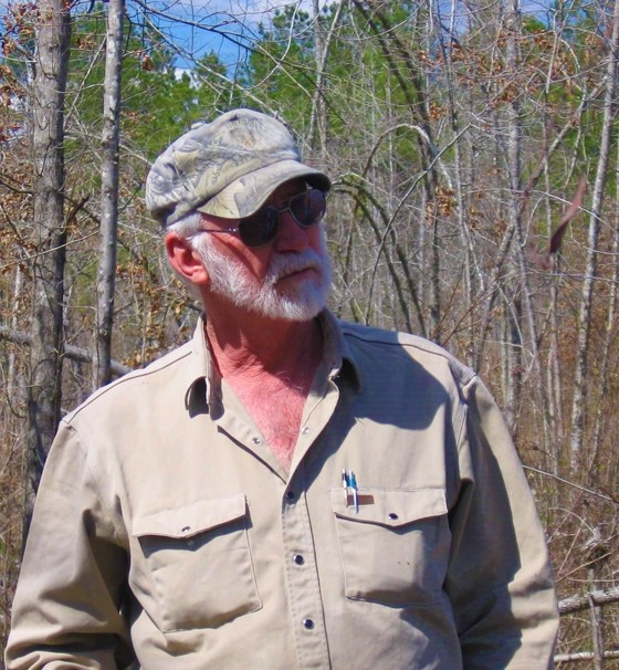
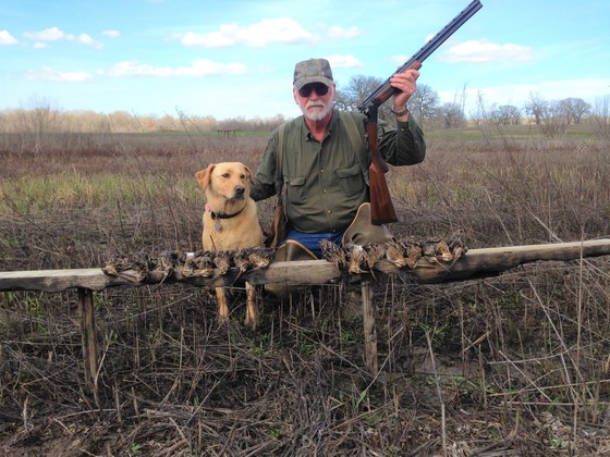 Former TPWD Biologist, Carl Frentress, after a successful hunt.
The North Unit of Richland Creek Wildlife Management Area (WMA) has been re-named the Carl Frentress Unit, in honor of TPWD Waterfowl Biologist Carl Frentress, in recognition of his love and contributions to science, land management and the sustainable use of our natural resources.
Carl served as a biologist with TPWD for 32 years and continued his conservation work in the private sector for another 14 years. He was passionate about the Trinity River and was instrumental in the establishment of Richland Creek WMA. His innovative insights into complex ecological systems had merit and implications far beyond his time.
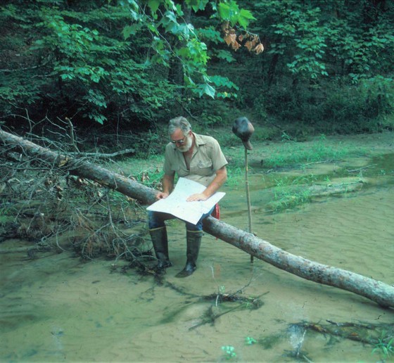 Former TPWD Biologist, Carl Frentress, studies a map along a creek bottom.
 Former TPWD biologist, Carl Frentress.
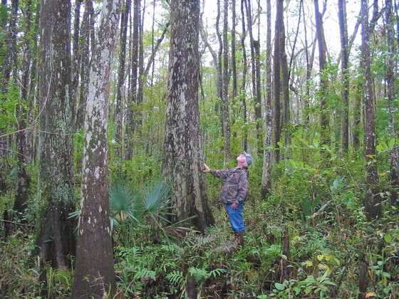 Former TPWD Biologist, Carl Frentress, inspecting timber.
Carl was a 5th generation east Texan and 1968 graduate of Texas A&M University, where he earned a degree in Wildlife and Fisheries Sciences. He was a tenacious, innovative and an articulate thinker, who embraced a common-sense approach to wildlife management and life. He was a Renaissance man who pursued knowledge and developed his capacity to the fullest, becoming an authority on history, English literature and folklore as well as wildlife and fisheries. His contributions in conservation ranged from aiding in the development of the Texas Wildlife Tax Valuation to improving wildlife management techniques and restoring wetlands, savannahs and native grass systems.
Carl had a deep and personal connection with his fellow rural landowners and practiced the land management he preached. Promoting conservation to these landowners on their farms, ranches and timber lands was very important to him. Carl interwove his gifts and talents in a unique manner and his definitive and eloquent speaking awoke people’s passion for the land and made them care for it. He was a mentor to countless young biologists and sportsmen and a friend to all Texans who appreciate the outdoors.
By: Matt Symmank, assistant project leader, Richland Creek WMA
Trends in Duck Distribution and Abundance
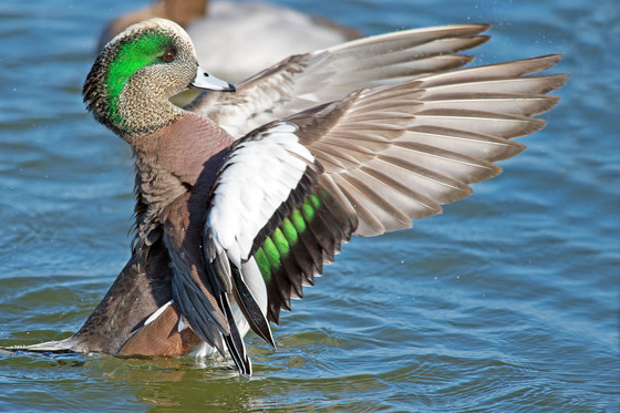 American wigeon. Photo: Brian Kushner, Courtesy: Audubon
Texas is extremely important to the continental waterfowl enterprise. The Lone Star state is home to three of the roughly 15 U.S. based priority areas identified by the North American Waterfowl Management Plan in the 1980s. These areas include the Playa Lakes, West Gulf Coastal Plain of the Lower Mississippi Alluvial Valley, and the Gulf Coast. Of those, the prairies, marshes, and bays of the Gulf Coast have been identified as one of the highest priority areas in the country.
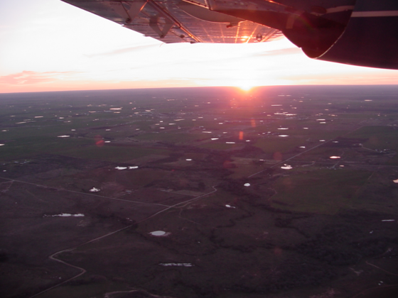
To put this in perspective, the Texas coastal region accounts for half of the waterfowl hunters and over half the waterfowl harvest for the state. Historically, as far back as the 1960s, the Gulf Coast accounted for up to 80% of all the ducks and geese counted in the state of Texas during the annual mid-winter waterfowl surveys. The coast was the only area in Texas that had a transect style survey dating back to the 1970s, which contrasted with the rest of the state, flown using a census or cruise style survey over reservoirs, rivers, and known areas of waterfowl concentrations. In the early 1990s TPWD biologists started noticing a growing number of ducks scattered across the state on small humanmade bodies of water called stock ponds; notably, these stock ponds were not being accounted for in the annual mid-winter waterfowl surveys. To address this disconnect, a survey redesign was necessary to more accurately assess and capture the landscape available to ducks in Texas and to incorporate new GPS technologies. In 1997, Texas rolled out a systematic, random transect-based survey that divided the state up into ecological stratum known as ecoregions. As a result, for the first time ever TPWD started getting landscape level, statically valid data to assess all of Texas’ important waterfowl habitats.
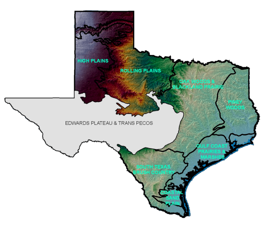
The waterfowl survey ecoregions include the High Plains, Rolling Plains, Oak Woods & Black Land Prairies (Oaks and Prairies), Pineywoods, Gulf Coast Prairies and Marshes (Gulf Coast), Coastal Sand Plains, and South Texas Brush Country. The Edwards Plateau and Trans Pecos regions of Texas are not flown due to low density of water bodies and the extensive number of survey hours that would be required to adequately cover those area. That said, TWPD biologists are fully aware that where there is water there is also a wide variety of ducks using those arid landscapes as well.
 Waterfowl survey ecoregions in Texas.
These individual ecoregions were assessed and transects were laid out to cover 1% of each area, except for the High Plains and Gulf Coast. The dynamic nature of playa wetlands did not lend themselves to a transects style design and thus a subset of playa wetlands were randomly selected from the playa database and those basins are flown each year and assessed for presence of water and waterfowl. The Gulf Coast survey design incorporated random transects that were designed to cover a certain percentage of the available waterfowl habitat types found on the Gulf Coast.
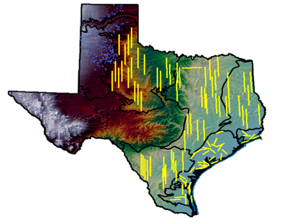 Survey transects and selected playas flown for mid-winter duck surveys in Texas.
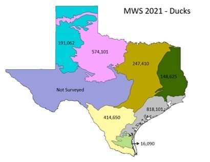
The impact of the survey changes was almost instantaneous and TPWD quickly began seeing a more complete picture of the state of Texas through the eyes of a duck. As expected, the Gulf Coast region still stood out as the area with the most ducks in 1997; the first year of the new survey, TPWD estimated half of all the ducks counted in Texas were observed on the Gulf Coast. However, some interesting numbers were observed within the Rolling Plains and the Oaks and Prairies, where TPWD estimated 1.3 million ducks using the abundant humanmade stock ponds. TPWD saw similar trends and patterns for the next several years, with expected ups and downs typically explained by weather and rainfall. The one thing that was really starting to become obvious as the years went by was that biologists continued to see increases in ducks wintering further inland most years and a gradual decline of all waterfowl along the Gulf Coast. In 2012, for the first time in documented history, TPWD counted more ducks in Oaks and Prairies than they did on the Gulf Coast, which only accounted for 36% of the state’s ducks. Five of the next 10 survey years showed similar results, where the Gulf Coast was not the number one ecoregion for ducks in Texas. There were even a few years where the Gulf Coast was 3rd or 4th in the state behind the High Plains, Rolling Plains, and Oaks and Prairies ecoregions. In 2016, TPWD estimated just 989,000 total ducks on the Gulf Coast, yet estimated 4.7 million in Texas, meaning coastal population accounted for just 20% of the ducks in the state (see maps at end of article for year to year change).
Currently, total duck numbers on the Gulf Coast are declining, especially dabbling ducks (Figure 1), while long-term trends for total ducks for the state of Texas continue to exhibit a positive trend (Figure 2). The only species of duck experiencing long-term declines is the mallard. Texas is just 4 years removed from an all-time high estimate of 6.11 million total ducks and two years removed from the fourth highest winter duck index on record. Additionally, Texas has shown a positive trend of the proportion of ducks counted in Texas compared to the total number of ducks counted in the Central Flyway (Figure 3). Both are encouraging signs that ducks are still coming to Texas in good numbers, just where in Texas the birds will settle seems to be the question each year.
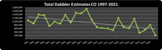 Figure 1. Total dabbling duck estimates along the Gulf Coast of Texas, 1997-2021.
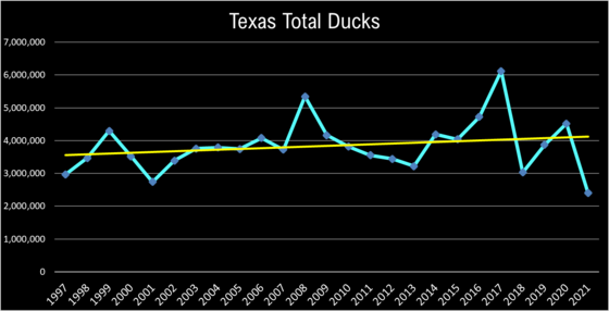 Figure 2. Total number of ducks in Texas, 1997-2021.
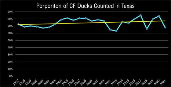 Figure 3. Proportion of Central Flyway ducks counted in Texas, 1997-2021.
Research and monitoring programs have shown that in ecoregions like the Oaks and Prairies and Rolling Plains in Texas, stock pond densities are as high as 9 per square mile and we are quickly approaching 1 million total stock ponds in these areas alone. Investigations into the time activity budgets for ducks (i.e., how they spend their day) in these regions show substantial feeding behavior throughout the day. Additionally, research on the feeding habits of hen mallards collected on stock ponds in the Oaks and Prairies revealed a wide a variety of foods consumed including invertebrates and seeds of all kinds (aquatic and terrestrial). Notably, the body condition indexes (a measure of overall health) of those birds ended up being the highest ever reported for female mallards during the non-breeding season.
 Stock ponds dot the Rolling Plains of Texas.
These stock ponds individually have a low overall carrying capacity (i.e., the total number of ducks the pond's resources can support on any given day or season), but as a complex (i.e., lots of ponds in a small area) they appear to be providing substantial foods resources and sanctuary from disturbance and hunting pressure. Ducks have apparently found these relatively new and rapidly increasing features on the landscape to be quite satisfactory to their needs, especially during times of drought and low availability of fresh water on the Gulf Coast. Even during the drought of record for Texas, 2010-2011, our mid-winter estimates for ducks stayed above the long-term average in large part due to an abundance of fresh water still on the landscape in these humanmade stock ponds.
The January 2021 mid-winter waterfowl survey indicted the lowest estimate of ducks in Texas since we started the new survey methodology in the late 1990s; the fall and winter of 2020-2021 was one for the books. Very warm temperatures up and down the Central Flyway simply did not push ducks as far south as they typically go. There was open, unfrozen water in North Dakota late into winter, a phenomenon than has rarely, if ever been recorded. We hope this is not a trend that holds up in the coming years but one thing we can feel confident about is that our survey redesign is helping us get best the best data possible to track and monitor duck populations in Texas, whatever changes happen up north.
By: Kevin Kraai, waterfowl program leader
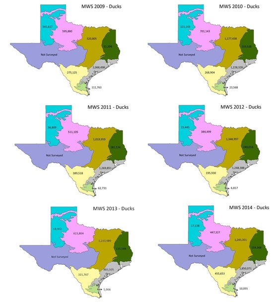 
Texas mid-winter waterfowl survey estimates by ecoregion, 1997-2021.
2021 Dove Population and Status Report
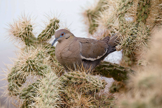 White-winged dove. Photo: David Blinder, Courtesy: Audubon
On average each year, 30% of the total mourning dove harvest and 84% of the total white-winged dove harvest in the United States occurs in Texas. Approximately 300,000 hunters take to the field annually, resulting in a yearly economic impact of $316 million ($427 million when adjusted for inflation). Regular monitoring of dove populations is essential to effectively managing and conserving such an important recreational and biological resource. Since 2008, TPWD has conducted rural and urban dove surveys to estimate annual spring breeding abundance, except for 2020 when survey were cancelled due to restrictions from the COVID-19 pandemic. This report provides updated results from these surveys for 2021 and provides information on hunter and harvest trends for mourning, white-winged, and Eurasian collared-doves in Texas. Enjoy!
By: Owen Fitzsimmons, webless migratory game bird program leader
Welcome to the New Rio Grande Joint Venture Coordinator

Karen Chapman will be starting on Oct 18 as the new Rio Grande Joint Venture Coordinator and will be based in Alpine, Texas. She brings to the position her experience in leadership positions, bird conservation, and working in the U.S. and Mexico portions of our borderlands, along with an abundance of energy and enthusiasm for conservation and our region. Karen grew up on a small farm in central Ohio, and as a child helped her grandfather with farm chores, discovering a love for nature in the woods and wetlands on the farm. She graduated from Miami University of Ohio in 1986 with a B.S. in Communication and minor in Spanish. She worked as a program manager for several radio stations in and around Cincinnati, then left Ohio to serve two years as a U.S. Peace Corps volunteer for the rural youth agriculture program in Ecuador, South America. Returning stateside, she began her conservation career on the U.S.-Mexico border.
Over the past 30 years, Karen has served in a variety of leadership positions with non-profit environmental organizations including the National Audubon Society, Texas Center for Policy Studies, and Environmental Defense Fund. Her work focused on ecosystems along the Texas-Mexico border as well as the Great Lakes, and encompassed environmental education, endangered species habitat restoration, habitat management, border environmental and water policy research and outreach, and managing on-farm research projects aimed at reducing climate impacts from agriculture. She has served on the Good Neighbor Environmental Board and as Chair of the National Advisory Committee to the EPA under the North American Agreement on Environmental Cooperation. We are very excited to have Karen on board, helping guide a diverse network of partners along the Rio Grande!
By: Jeff Raasch, conservation partnership and joint venture program leader
|
Tools to Inform Playa Management Decisions
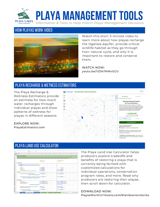 Playa management flyer, Playa Lakes Joint Venture (click to open and download).
Healthy playas provide many benefits for people including groundwater recharge, water filtration, erosion and flood control, and hunting and wildlife viewing opportunities. Not only are playas a primary source of recharge to the Ogallala aquifer, but they also improve the quality of the groundwater.
Over the years, many playas have become degraded and may no longer function properly; however, when restored, playas can again provide clean water for people and habitat for wildlife. There are several state and federal programs — including the Texas Playa Conservation Initiative — available to help landowners restore water flow into their playas, fill in pits and ditches, establish grass buffers to prevent excess sediment accumulation, and manage grazing.
Two new tools from Playa Lakes Joint Venture can help producers make decisions about how to manage their playas. One tool helps determine how financial offerings from various conservation programs — such as the Environmental Quality Incentives Program, Wetland Reserve Easements, Conservation Reserve Program (CRP), and CRP practices that use a bid process — can meet operational objectives, while the other allows users to explore recharge potential through playas.
The Playa Land Use Calculator helps producers explore tradeoffs and benefits of restoring a playa that is currently being farmed with customized calculations for individual operations, rates for conservation programs, and more. Learn more about conservation programs and download the calculator at PlayasWorkForTexans.com/#landownerstories.
The Playa Recharge & Wetness Estimators provide an estimate for how much water recharges through individual playas and show patterns of wetness for playas in different seasons. Learn more about how playas recharge the Ogallala aquifer and use the estimators at PlayasWorkForTexans.com/#groundwater.
By: Miruh Hamed, communications director, Playa Lakes Joint Venture
Funding for the development of these tools was provided by USDA Natural Resources Conservation Service in Kansas and New Mexico and by High Plains Water District in Texas.
 Playa Land Use Calculator, Playa Lakes Joint Venture.
|