|
News media contact:
Hannah Schafer
(971) 235-8472
hannah.schafer@portlandoregon.gov
@pbotinfo
News Blog:
A new strategy for East Portland
PBOT’s East Portland Arterial Streets Strategy report shows the positive, transformative potential of more than a dozen road projects in East Portland.
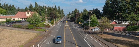 NE Glisan Street following changes to the lane configuration to create safer street conditions. Photo by PBOT.
(Aug. 3, 2021) The Portland Bureau of Transportation (PBOT), with the help of consultants HDR and Toole Design, recently completed a study called the East Portland Arterial Streets Strategy, or EPASS for short. Looking at over 42 miles of major streets east of 82nd Avenue, this wide-ranging transportation study focused on more than a dozen projects slated for East Portland. What would the potential safety benefit be? How would they impact congestion?
PBOT and their consultants made recommendations based on these traffic and travel studies as well as the work of a technical advisory committee, a review of recent public comments on projects in the area, and a questionnaire.
The full report is available here on the EPASS website.
Safety and congestion
The EPASS study was started because of two concerns PBOT repeatedly heard from East Portland community members. The first concern was safety and the fact that serious and fatal crashes, as well as speeding, continue to plague East Portland’s busiest streets, areas that also have substandard infrastructure for pedestrians and people biking. The second concern was congestion and the worry that converting vehicle lanes to bike or bus-only lanes would increase traffic congestion, especially if these changes went in on multiple streets in the same area.
As a district-wide traffic and travel study, EPASS allowed the bureau to look closely at a menu of proven safety interventions, then find the best mix of solutions to address both these concerns. That is, how could our construction projects make these busy roads in East Portland safer, while also keeping people and goods moving.
Key takeaways
Here are some highlights from the report, all of which can be found on PBOT’s EPASS website:
-
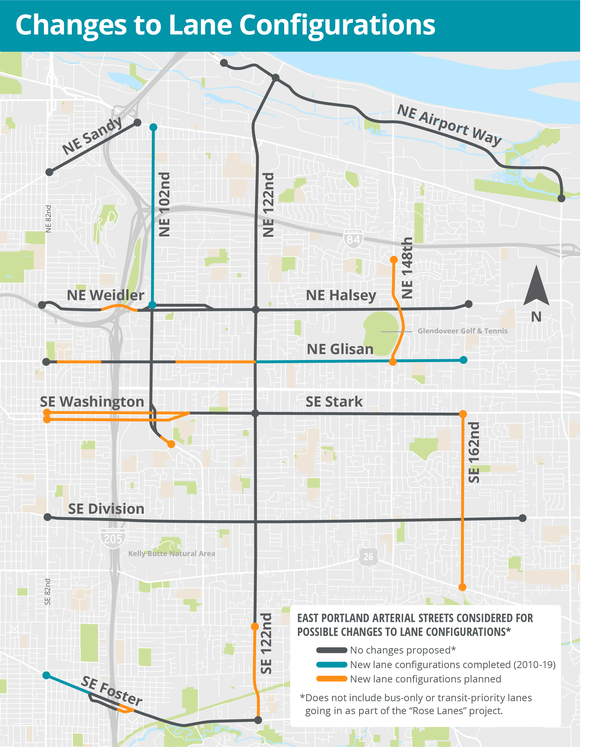
An arterial network, mapped: PBOT and their consultants studied all the streets in East Portland—that is, east of 82nd Avenue—which had four or more vehicle lanes as of 2018 and are maintained by PBOT. This arterial network of 11 streets stretches from NE Airport Way to SE Foster Road, from 102nd to 162nd avenues, a total of nearly 42 miles.
-
A much-needed focus on preventing traffic fatalities: East Portland is home to roughly one quarter of Portland’s population, but half of the city’s traffic deaths. In fact, of Portland’s top 30 high-crash intersections—noted for serious and fatal crashes—28 intersections are in East Portland and 17 of those are on the network of arterials PBOT studied for EPASS. There are many root causes of these crashes, including the design of how these streets have functioned in the past. This includes streets that are difficult to cross, that have poor street lighting, or are so wide and open, they encourage speeding and other risky behavior. Many of these crash locations are also where there are no medians or other barriers that prevent dangerous turns into businesses and driveways.
-
Congestion may be here to stay: Although PBOT has numerous programs to encourage walking, biking, rolling, and taking transit—and continues to build infrastructure in support of these ways of getting around—much of East Portland remains centered around the automobile. This has a lot to do with East Portland’s location, land-use patterns, and the types and locations of jobs East Portlanders have. During the strictest Covid-19 lockdowns of spring 2020, vehicle traffic declined about 60% in and around the central city. In East Portland, it decreased only 30%, then rebounded quickly. To model what travel will look like in the future, PBOT looks at all the changes coming to the transportation network and land-use patterns. PBOT predicts that driving in East Portland will decrease as a percentage of total trips taken, but not nearly as much as in neighborhoods closer to downtown. Even with less driving per capita in East Portland, the total number of trips taken by car is expected to increase in East Portland as the Portland metro region continues to grow.
-
A wide range of targeted solutions: PBOT is building for safety in East Portland with proven, effective improvements. This includes new signalized pedestrian crossings, better street lighting, and changes to the phasing of signals to help protect pedestrians. PBOT is also installing automated speed-safety cameras, high-visibility crosswalks, concrete medians, and protected bike lanes. We are also changing the lane configurations on some wider sections, creating more protected space for people biking and buses. PBOT picks the tools that will work best for each section of the road. Factors we consider are street width, traffic volume, land-use patterns, and the types of crashes occurring.
-
New lane configurations will work well on a third of East Portland arterials: There is one major safety improvement the EPASS report makes clear will meet the community’s goals on safety: new lane configurations. This means reducing the number of travel lanes, or changing their purpose for bike lanes, center-turn lanes, pedestrian islands, and/or bus-only traffic. The EPASS report makes clear that this is an effective solution for about a third of these arterials. By effective, we mean that these changes would both increase safety and have a minimal effect on congestion. The map here shows where changes to lane configurations have already been completed, or are planned for the future. Results are already positive.
 |
-
Some streets will not change lane configuration, but still need safety fixes: The EPASS study looked at some busy streets, such as SE Division and Stark streets, and most of 122nd Avenue, where the modeling showed that changing lane configurations would not have the same benefits as elsewhere. For one, the increase in congestion could prompt people frustrated with traffic to drive through neighborhood streets and bike routes that already lack sidewalks. Furthermore, new lane configurations, when there is congestion in both directions, but an “open” center-turn lane could encourage risky driving behavior, or increase the risk to pedestrians trying to cross where there’s rarely a break in traffic. The EPASS study recommends an array of other safety interventions on these sections of road. This includes pedestrian crossings with signals, concrete medians, and protected bike lanes.
-
Learn more about every project, funded or planned: The EPASS final report and website provides information and links to the 15 funded projects already underway to make East Portland arterials safer. The report also provides the initial scope on nine additional safety projects for East Portland arterials for which PBOT is currently seeking funding.
-
Explainer videos: PBOT produced two videos to explain the logic behind the changing lane configurations: the Designing a Smarter Street for Portland video and the Safe 4-Lane Boulevards in East Portland video. Both videos can also be found on the EPASS website.
Learn more
PBOT’s East Portland Arterial Streets Strategy (EPASS) website includes our final report, technical appendices, and a list of active projects on these arterials, with links to their project pages. If you have questions on these projects, contact the individual project managers at PBOT.
The Portland Bureau of Transportation (PBOT) is the steward of the city’s transportation system and a community partner in shaping a livable city. We plan, build, manage, and maintain an effective and safe transportation system that provides access and mobility. Learn more at portland.gov/transportation
|